DAMS IN YAVATMAL DISTRICT - PART TWO. (EDITED)
All 33 blogs covering 380 dams in 11 Districts of Vidarbha Region were edited between Aug & Sept 2020. For details go to blog "Vidarbha Region. Edit-Now - Why". Link here.
There are total of 59 Major Dams ( Height from foundation 10 meters or more ) in Yavatmal District. Information on these parts is covered in Five Parts.
Part One. 1.Bembla. 2.Sirasgaon. 3.Lohatwadi. 4. Ner. 5.Kapara. 6.Takali. 7. Zola. 8.Borgaon.
7. Zola. 8.Borgaon. 9.Ghoti.10.Duttapur. 11.Rajur. 12.Durug. 13.Pimpalkhuti.
Part Two 14.Warud. 15.Anji. 16. Bhulgad. 17. Antargaon. 18.Jamwadi. 19.Nilona. 20. Kharad. 21.Ghatana. 22.Chapdoh. 23.Waghadi. 24.Kumbharkinhi. 25.Kumbharkini. 26.Goki.
27.Wardh.
Part Three. 28.Vihirgaon. 29.Khemkund. 30.Munzala / Munjala. 31. Karanji. 32. Dhdhana,
33.Chorkund. 33.Chorkund.34.Arunawati. 35.Saikheda. 36.Wai. 37.Nawargaon.
38.Khandani. 39.Maisdodak.
Part Four. 40.Muchi.41. Rampur. 42. Borda. 43. Rasa. 44. Kharda Barrage. 45.Kinhi.
46.Nandgavhan. 47.Rui. 48.Upper Pus (Pus). 49. Lower Pus. 50.Khadakdoh.
Part Five. 51.Jambnala. 52.Senad. 53.Mudana. 54.Pimpalgaon. 55.Pophali. 56. Marsul.57.Nignoor. 58.Piranji. 59.Darati .
14.Warud. ( Latitude : 20.3229773N, Longitude : 78.5286427E )

Map & link uploaded Aug - Sept 2020.
For viewing the surrounding areas and map page click Here.
Some information about Warud Irrigation Project.
Official Designation of Warud Dam Irrigation Project is " Warud Dam , D -05070 " . However local and popular name is " Warud Lake / Warud Talav " . Warud Dam was constructed as part of Irrigation Projects by the Government of Maharashtra in the year 1997. It is built on and impounds a local Nallah . Nearest city to dam is Ralegaon in Yavatmal District of Maharashtra . The dam is an Earth fill Dam .The purpose of the dam is for Irrigation.The Length of dam is 1110 m ( 3641.732 Feet ) , while the Height of the dam above lowest foundation is 18.32 m ( 60.1049 Feet ) . Any type of information about the Project Spillway is not available at all.. Length of the spillway is .not known. The Dam has ungated spillway. .Dam's catchment area is not known . Maximum / Gross storage capacity is 8.942 MCM. Live storage capacity is 8..23 MCM. . Now a days almost all the water bodies make for good picnic spots Warud Lake is also a popular picnic spot for its scenic beauty.
Official Designation of Warud Dam Irrigation Project is " Warud Dam , D -05070 " . However local and popular name is " Warud Lake / Warud Talav " . Warud Dam was constructed as part of Irrigation Projects by the Government of Maharashtra in the year 1997. It is built on and impounds a local Nallah . Nearest city to dam is Ralegaon in Yavatmal District of Maharashtra . The dam is an Earth fill Dam .The purpose of the dam is for Irrigation.The Length of dam is 1110 m ( 3641.732 Feet ) , while the Height of the dam above lowest foundation is 18.32 m ( 60.1049 Feet ) . Any type of information about the Project Spillway is not available at all.. Length of the spillway is .not known. The Dam has ungated spillway. .Dam's catchment area is not known . Maximum / Gross storage capacity is 8.942 MCM. Live storage capacity is 8..23 MCM. . Now a days almost all the water bodies make for good picnic spots Warud Lake is also a popular picnic spot for its scenic beauty.
(Note : Blue area in normal map corresponds to Maximum / Full Reservoir Level.)
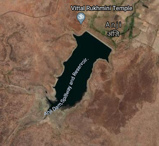
15.Anji. ( Latitude : 20.2929122N, Longitude : 78.570056E )
15.Anji. ( Latitude : 20.2929122N, Longitude : 78.570056E )
Map & link uploaded Aug - Sept 2020.
For viewing the surrounding areas and map page click Here.
Some information about Anji Irrigation Project.
Official Designation of Anji Dam Irrigation Project is " Anji Dam , D -03307 " . However local and popular name is " Anji Lake / Anji Talav " . Anji Dam was constructed as part of Irrigation Projects by the Government of Maharashtra in the year 1986. It is built on and impounds a local Nallah . Nearest city to dam is Ralegaon in Yavatmal District of Maharashtra . The dam is an Earth fill Dam .The purpose of the dam is for Irrigation.The Length of dam is 385 m ( 1263.12 Feet ) , while the Height of the dam above lowest foundation is 20.37 m ( 66.8307 Feet ) . Any type of information about the Project Spillway is not available at all.. Length of the spillway is not known. The Dam has ungated spillway. Dam's catchment area is not known . Maximum / Gross storage capacity is 2.8 MCM. Live storage capacity is 2.68 MCM. . Now a days almost all the water bodies make for good picnic spots Anji Lake is also a popular picnic spot for its scenic beauty.
Official Designation of Anji Dam Irrigation Project is " Anji Dam , D -03307 " . However local and popular name is " Anji Lake / Anji Talav " . Anji Dam was constructed as part of Irrigation Projects by the Government of Maharashtra in the year 1986. It is built on and impounds a local Nallah . Nearest city to dam is Ralegaon in Yavatmal District of Maharashtra . The dam is an Earth fill Dam .The purpose of the dam is for Irrigation.The Length of dam is 385 m ( 1263.12 Feet ) , while the Height of the dam above lowest foundation is 20.37 m ( 66.8307 Feet ) . Any type of information about the Project Spillway is not available at all.. Length of the spillway is not known. The Dam has ungated spillway. Dam's catchment area is not known . Maximum / Gross storage capacity is 2.8 MCM. Live storage capacity is 2.68 MCM. . Now a days almost all the water bodies make for good picnic spots Anji Lake is also a popular picnic spot for its scenic beauty.
(Note : Blue area in normal map corresponds to Maximum / Full Reservoir Level.)
16. Bhulgad. ( Latitude : 20.270581N, Longitude : 78.5982728E )

Map & link uploaded Aug - Sept 2020.
For viewing the surrounding areas and map page click here.
Some information about Bhulgad Irrigation Project.
Official Designation of Bhulgad Dam Irrigation Project is " Bhulgad Dam , D -03463 " . However local and popular name is " Bhulgad Lake / Bhulgad Talav " . Bhulgad Dam was constructed as part of Irrigation Projects by the Government of Maharashtra in the year 1980. It is built on and impounds a local Nallah . Nearest city to dam is Khadakdoh in Yavatmal District of Maharashtra . The dam is an Earth fill Dam .The purpose of the dam is for Irrigation .The Length of dam is 508 m ( 1666.67 Feet ) , while the Height of the dam above lowest foundation is 16.3 m ( 53.477 Feet ) . Any type of information about the Project Spillway is not available at all. Project has no proper spillway as such . .Dam's catchment area is not known .Maximum / Gross storage capacity is not known. Live storage capacity is not known. Now a days almost all the water bodies make for good picnic spots Bhulgad Lake is also a popular picnic spot for its scenic beauty.
Official Designation of Bhulgad Dam Irrigation Project is " Bhulgad Dam , D -03463 " . However local and popular name is " Bhulgad Lake / Bhulgad Talav " . Bhulgad Dam was constructed as part of Irrigation Projects by the Government of Maharashtra in the year 1980. It is built on and impounds a local Nallah . Nearest city to dam is Khadakdoh in Yavatmal District of Maharashtra . The dam is an Earth fill Dam .The purpose of the dam is for Irrigation .The Length of dam is 508 m ( 1666.67 Feet ) , while the Height of the dam above lowest foundation is 16.3 m ( 53.477 Feet ) . Any type of information about the Project Spillway is not available at all. Project has no proper spillway as such . .Dam's catchment area is not known .Maximum / Gross storage capacity is not known. Live storage capacity is not known. Now a days almost all the water bodies make for good picnic spots Bhulgad Lake is also a popular picnic spot for its scenic beauty.
(Note : Blue area in normal map corresponds to Maximum / Full Reservoir Level.)
17. Antargaon. ( Latitude : 20.270581N, Longitude : 78.5982728E )

Map & link uploaded Aug - Sept 2020.
For viewing the surrounding areas and map page click here.
Some information about Antargaon Irrigation Project.
Official Designation of Antargaon Dam Irrigation Project is " Antargaon Dam , D -01440 " . However local and popular name is " Antargaon Lake / Antargaon Talav " . Antargaon Dam was constructed as part of Irrigation Projects by the Government of Maharashtra in the year 1986. It is built on and impounds Khuni Nalla River . Nearest city to dam is Yavatmal in Yavatmal District of Maharashtra . The dam is an Earth fill + masonry Dam .The purpose of the dam is for Irrigation .The Length of dam is 1078 m ( 3536.74 Feet ) , while the Height of the dam above lowest foundation is 17.42 m ( 57.152 Feet ) . The Project has other type of Spillway . Length of the spillway is 108 m ( 354.331 Feet ). The Dam has ungated spillway . The Dam's catchment area is 2.9785 Thousand Hectors . Maximum / Gross storage capacity is 7.202 MCM. Live storage capacity is 6.28 MCM. Now a days almost all the water bodies make for good picnic spots Antargaon Lake is also a popular picnic spot for its scenic beauty.
Official Designation of Antargaon Dam Irrigation Project is " Antargaon Dam , D -01440 " . However local and popular name is " Antargaon Lake / Antargaon Talav " . Antargaon Dam was constructed as part of Irrigation Projects by the Government of Maharashtra in the year 1986. It is built on and impounds Khuni Nalla River . Nearest city to dam is Yavatmal in Yavatmal District of Maharashtra . The dam is an Earth fill + masonry Dam .The purpose of the dam is for Irrigation .The Length of dam is 1078 m ( 3536.74 Feet ) , while the Height of the dam above lowest foundation is 17.42 m ( 57.152 Feet ) . The Project has other type of Spillway . Length of the spillway is 108 m ( 354.331 Feet ). The Dam has ungated spillway . The Dam's catchment area is 2.9785 Thousand Hectors . Maximum / Gross storage capacity is 7.202 MCM. Live storage capacity is 6.28 MCM. Now a days almost all the water bodies make for good picnic spots Antargaon Lake is also a popular picnic spot for its scenic beauty.
(Note : Blue area in normal map corresponds to Maximum / Full Reservoir Level.)
18.Jamwadi. ( Latitude : 20.270581N, Longitude : 78.5982728E )
18.Jamwadi. ( Latitude : 20.270581N, Longitude : 78.5982728E )

Map & link uploaded Aug - Sept 2020.
For viewing the surrounding areas and map page click Here.
Some information about Jamwadi Irrigation Project.
There are two dams with the name Jamwadi in Maharashtra. .1.near Jalna in Jalna District and 2. near Ner in Yavatmal District.
In some places and maps this place has also been spelt as 'Jambwadi' . Here Official spelling of 'Jamwadi' will be used. Official Designation of Jamwadi Dam Irrigation Project is " Jamwadi Dam , D - 04001 " . However local and popular name is " Jamwadi/ Lake / Jamwadi Talav " . Jamwadi Dam was constructed as part of Irrigation Projects by the Government of Maharashtra in the year 1977. It is built on and impounds a local Nallah . Nearest city to dam is Yavatmal in Yavatmal District of Maharashtra . The dam is an Earth fill Dam .The purpose of the dam is for Irrigation .The Length of dam is 398 m ( 1305.77 Feet ) , while the Height of the dam above lowest foundation is 12.95 m ( 42.48 Feet ) . The Project has other type of Spillway . However any other information about the spillway is not available at all. . Length of the spillway is not known. The Dam has ungated spillway. .Dam's catchment area is not known . Maximum / Gross storage capacity is 2.36 MCM. Live storage capacity is 2.16 MCM. Now a days almost all the water bodies make for good picnic spots Jamwadi Lake is also a popular picnic spot for its scenic beauty.
(Note : Blue area in normal map corresponds to Maximum / Full Reservoir Level.)
19.Nilona. ( Latitude : 20.3253818N, Longitude : 78.153069E )
19.Nilona. ( Latitude : 20.3253818N, Longitude : 78.153069E )

Map & link uploaded Aug - Sept 2020.
For viewing the surrounding areas and map page click Here.
Some information about Nilona Irrigation Project.
Official Designation of Nilona Dam Irrigation Project is " Nilona Dam , D - 04456 " . However local and popular name is " Nilona Lake / Nilona Talav " . Nilona Dam was constructed as part of Irrigation Projects by the Government of Maharashtra in the year 1974. It is built on and impounds Waghadi River . Nearest city to dam is Yavatmal in Yavatmal District of Maharashtra . The dam is an Earth fill Dam .The purpose of the dam is for Irrigation and Drinking / Water Supply.The Length of dam is 274 m ( 898.95 Feet ).There appears to be an error in this figure given in india-wris.nrsc.gov.in, web site The length as measured works out to 679 m (2227.69 Feet ) divided in two parts ,One 293 m ( 961.28 Feet ) Southern portion + other 386 m ( 1266.4 Feet ) Northern portion . These two parts are separated by a spillway 219 m ( 718.50 Feet ) long . while the Height of the dam above lowest foundation is 16 m ( 52.49 Feet ) . The Project has other type of Spillway however detailed and any other information about the spillway is not available at all. Length of the spillway as given earlier is , 219 m ( 718.50 Feet ). The Dam has ungated spillway . Dam's catchment area is not known . Maximum / Gross storage capacity is 6.89 MCM. Live storage capacity is 6.39 MCM. Now a days almost all the water bodies make for good picnic spots Nilona Lake is also a popular picnic spot for its scenic beauty.
Official Designation of Nilona Dam Irrigation Project is " Nilona Dam , D - 04456 " . However local and popular name is " Nilona Lake / Nilona Talav " . Nilona Dam was constructed as part of Irrigation Projects by the Government of Maharashtra in the year 1974. It is built on and impounds Waghadi River . Nearest city to dam is Yavatmal in Yavatmal District of Maharashtra . The dam is an Earth fill Dam .The purpose of the dam is for Irrigation and Drinking / Water Supply.The Length of dam is 274 m ( 898.95 Feet ).There appears to be an error in this figure given in india-wris.nrsc.gov.in, web site The length as measured works out to 679 m (2227.69 Feet ) divided in two parts ,One 293 m ( 961.28 Feet ) Southern portion + other 386 m ( 1266.4 Feet ) Northern portion . These two parts are separated by a spillway 219 m ( 718.50 Feet ) long . while the Height of the dam above lowest foundation is 16 m ( 52.49 Feet ) . The Project has other type of Spillway however detailed and any other information about the spillway is not available at all. Length of the spillway as given earlier is , 219 m ( 718.50 Feet ). The Dam has ungated spillway . Dam's catchment area is not known . Maximum / Gross storage capacity is 6.89 MCM. Live storage capacity is 6.39 MCM. Now a days almost all the water bodies make for good picnic spots Nilona Lake is also a popular picnic spot for its scenic beauty.
(Note : Blue area in normal map corresponds to Maximum / Full Reservoir Level.)
20. Kharad. ( Latitude :20.3253818N , Longitude : 78.153069E )
20. Kharad. ( Latitude :20.3253818N , Longitude : 78.153069E )

Map & link uploaded Aug - Sept 2020.
.
For viewing the surrounding areas and map page click here.
Some information about Kharad Irrigation Project.
Official Designation of Kharad Dam Irrigation Project is " Kharad Dam , D - 04155 " . However local and popular name is " Kharad Lake / Kharad Talav " . Kharad Dam was constructed as part of Irrigation Projects by the Government of Maharashtra in the year 1975. It is built on and impounds a local Nallah Nearest city to dam is Yavatmal in Yavatmal District of Maharashtra . The dam is an Earth fill + masonry Dam .The purpose of the dam is for Irrigation,Drinking / Water Supply.The Length of dam is 398 m ( 1305.77 Feet ) , while the Height of the dam above lowest foundation is 12.95 m ( 42.48 Feet ) . The Project has other type of Spillway , however detailed and any other information about the spillway is not available at all. Project has no proper spillway as such . Length of the spillway is not known. Dam's catchment area is not known . Maximum / Gross storage capacity is 3.59 MCM. Live storage capacity is 3.25 MCM. Now a days almost all the water bodies make for good picnic spots Kharad Lake is also a popular picnic spot for its scenic beauty.
(Note : Blue area in normal map corresponds to Maximum / Full Reservoir Level.)
21.Ghatana. ( Latitude : 20.2465756N, Longitude : 78.1178999E )

Map & link uploaded Aug - Sept 2020.
For viewing the surrounding areas and map page click here.
Some information about Ghatana Irrigation Project.
Official Designation of Ghatana Dam Irrigation Project is " Ghatana Dam , D - 03848 " . However local and popular name is " Ghatana Lake / Ghatana Talav " . Ghatana Dam was constructed as part of Irrigation Projects by the Government of Maharashtra in the year 1978. It is built on and impounds a local Nallah . Nearest city to dam is Yavatmal in Yavatmal District of Maharashtra . The dam is an Earth fill Dam .The purpose of the dam is for Irrigation,.The Length of dam is 531 m ( 1742.13 Feet ) , while the Height of the dam above lowest foundation is 11.16m ( 36.61 Feet ) . The Project has other type of Spillway however detailed and any other information about the spillway is not available at all. Length of the spillway is not known. The Dam has ungated spillway. Dam's catchment area is not known . Maximum / Gross storage capacity is 1.29 MCM. Live storage capacity is 1.21 MCM. Now a days almost all the water bodies make for good picnic spots Ghatana Lake is also a popular picnic spot for its scenic beauty.
Official Designation of Ghatana Dam Irrigation Project is " Ghatana Dam , D - 03848 " . However local and popular name is " Ghatana Lake / Ghatana Talav " . Ghatana Dam was constructed as part of Irrigation Projects by the Government of Maharashtra in the year 1978. It is built on and impounds a local Nallah . Nearest city to dam is Yavatmal in Yavatmal District of Maharashtra . The dam is an Earth fill Dam .The purpose of the dam is for Irrigation,.The Length of dam is 531 m ( 1742.13 Feet ) , while the Height of the dam above lowest foundation is 11.16m ( 36.61 Feet ) . The Project has other type of Spillway however detailed and any other information about the spillway is not available at all. Length of the spillway is not known. The Dam has ungated spillway. Dam's catchment area is not known . Maximum / Gross storage capacity is 1.29 MCM. Live storage capacity is 1.21 MCM. Now a days almost all the water bodies make for good picnic spots Ghatana Lake is also a popular picnic spot for its scenic beauty.
(Note : Blue area in normal map corresponds to Maximum / Full Reservoir Level.)
22.Chapdoh. ( Latitude : 20.2622575N, Longitude : 78.2117343E )
22.Chapdoh. ( Latitude : 20.2622575N, Longitude : 78.2117343E )

Map & link uploaded Aug - Sept 2020.
For viewing the surrounding areas and map page click here.
Some information about Chapdoh Irrigation Project.
Project and Dam's Official Designation is "Chapdoh D - 03138" . Chapdoh Dam was constructed as part of irrigation projects by Government of Maharashtra . The year of completion of the Project is not known. . It is built on and impounds Waghadi Nalla / River , nearest city to dam is Chapdoh in Yavatmal District of Maharashtra . The dam is an Earth fill Dam . The purpose of the dam is for Irrigation and drinking water supply.The length of dam is 490.3 m ( 1608.59 ft ) , while the height of the dam above lowest foundation is 24.1m ( 79.07 Feet ) . Project has a Spillway of Ogee type . Length of the spillway is 152.2 m ( 499.34 Feet ). The Spillway is Ungated . Dam's catchment area is 12.266 thousand hectors . Maximum / Gross storage capacity is 13.127 MCM. Live storage capacity is 12.19 MCM. Like all the water bodies now a days , Chapdoh also makes for a good picnic spot.
Project and Dam's Official Designation is "Chapdoh D - 03138" . Chapdoh Dam was constructed as part of irrigation projects by Government of Maharashtra . The year of completion of the Project is not known. . It is built on and impounds Waghadi Nalla / River , nearest city to dam is Chapdoh in Yavatmal District of Maharashtra . The dam is an Earth fill Dam . The purpose of the dam is for Irrigation and drinking water supply.The length of dam is 490.3 m ( 1608.59 ft ) , while the height of the dam above lowest foundation is 24.1m ( 79.07 Feet ) . Project has a Spillway of Ogee type . Length of the spillway is 152.2 m ( 499.34 Feet ). The Spillway is Ungated . Dam's catchment area is 12.266 thousand hectors . Maximum / Gross storage capacity is 13.127 MCM. Live storage capacity is 12.19 MCM. Like all the water bodies now a days , Chapdoh also makes for a good picnic spot.
(Note : Blue area in normal map corresponds to Maximum / Full Reservoir Level.)
23.Waghadi. ( Latitude : 20.2571243N, Longitude : 78.3128643E)
23.Waghadi. ( Latitude : 20.2571243N, Longitude : 78.3128643E)

Map & link uploaded Aug - Sept 2020.
For viewing the surrounding areas and map page click here.
Some information about Waghadi Irrigation Project.
Waghadi Project and Dam's Official Designation is "Waghadi , D -01427" . Waghadi Dam was constructed as part of irrigation projects by Government of Maharashtra in the year 1978 . It is built on and impounds Waghadi River , nearest city to dam is Ghatanji in Yavatmal District of Maharashtra . The dam is an Earthfill Gravity Dam .The length of dam is 960 m ( 3149.61 Feet ) , while the height of the dam above lowest foundation is 26 m ( 85.30 Feet ) . The Project has a Spillway of Other type . Length of the spillway is 170 m ( 557.74 Feet ). The Spillway is Ungated . Dam's catchment area is 23.84 Thousand hectors. Maximum / Gross storage capacity is 41.11 MCM. Live storage capacity is 35.36 MCM. Now a days almost all the water bodies make for good picnic spots. Waghadi lake is also a popular attraction for its scenic beauty.
Waghadi Project and Dam's Official Designation is "Waghadi , D -01427" . Waghadi Dam was constructed as part of irrigation projects by Government of Maharashtra in the year 1978 . It is built on and impounds Waghadi River , nearest city to dam is Ghatanji in Yavatmal District of Maharashtra . The dam is an Earthfill Gravity Dam .The length of dam is 960 m ( 3149.61 Feet ) , while the height of the dam above lowest foundation is 26 m ( 85.30 Feet ) . The Project has a Spillway of Other type . Length of the spillway is 170 m ( 557.74 Feet ). The Spillway is Ungated . Dam's catchment area is 23.84 Thousand hectors. Maximum / Gross storage capacity is 41.11 MCM. Live storage capacity is 35.36 MCM. Now a days almost all the water bodies make for good picnic spots. Waghadi lake is also a popular attraction for its scenic beauty.
(Note : Blue area in normal map corresponds to Maximum / Full Reservoir Level.)
24.Kumbharkinhi. ( Latitude : 20.3024515N, Longitude : 77.6784897E)
24.Kumbharkinhi. ( Latitude : 20.3024515N, Longitude : 77.6784897E)
There is another dam with the same name jut about 500 meters South of this dam.

Map & link uploaded Aug - Sept 2020.
For viewing the surrounding areas and map page click here.
Some information about Kumbharkinhi Irrigation Project.
Kumbharkinhi Project and Dam's Official Designation is "Kumbharkinhi , D -0 4221" Locally it is also known as Bahirji Naik Talav .Kumbharkinhi Dam and Reservoir is an irrigation project near town of Darwah in Yavatmal district Kumbharkinhi Dam was constructed as part of irrigation projects by Government of Maharashtra in the year 2002 . It is built on and impounds Kuptanalla River , nearest city to dam is Daewha in Yavatmal District of Maharashtra . The dam is an Earthfill Gravity Dam .The length of dam is 1079 m ( 3540.02 Feet ) , while the height of the dam above lowest foundation is 18.1m ( 59.38 Feet ) . Any other information about the Project like spillway, gates , catchment area, reservoir capacities etc are not available at all.
Bahirji Naik Lake.
This lake is named after great spy Bahirji Naik..He was chief of intelligence department of Shivaji Maharaj.
(Note : Blue area in normal map corresponds to Maximum / Full Reservoir Level.)
25.Kumbharkini. ( Latitude : 20.292087N, Longitude : 77.6807857E )
There is another dam with the same name jut about 500 meters North of this dam.

Map & link uploaded Aug - Sept 2020.
For viewing the surrounding areas and map page click here.
Some information about Kumbharkini Irrigation Project.
Kumbharkini Project and Dam's Official Designation is "Kumbharkini , D - 0 4222" . Kumbharkini Dam was constructed as part of irrigation projects by Government of Maharashtra in the year 1976 . It is built on and impounds a local nallah, nearest city to dam is Darwha in Yavatmal District of Maharashtra . The dam is an Earthfill Gravity Dam .The length of dam is 390 m ( 1279.53 Feet ) , while the height of the dam above lowest foundation is 12.06 m ( 39.56 Feet ) . Gross Storage Capacity of the reservoir is 1.43 MCM . Live storage capacity is 1.38 MCM Any other information about the Project is not available at all.
Kumbharkini Project and Dam's Official Designation is "Kumbharkini , D - 0 4222" . Kumbharkini Dam was constructed as part of irrigation projects by Government of Maharashtra in the year 1976 . It is built on and impounds a local nallah, nearest city to dam is Darwha in Yavatmal District of Maharashtra . The dam is an Earthfill Gravity Dam .The length of dam is 390 m ( 1279.53 Feet ) , while the height of the dam above lowest foundation is 12.06 m ( 39.56 Feet ) . Gross Storage Capacity of the reservoir is 1.43 MCM . Live storage capacity is 1.38 MCM Any other information about the Project is not available at all.
(Note : Blue area in normal map corresponds to Maximum / Full Reservoir Level.)
26.Goki. ( Latitude : 20.2879612N, Longitude : 77.9090309E )
26.Goki. ( Latitude : 20.2879612N, Longitude : 77.9090309E )

Map & link uploaded Aug - Sept 2020.
For viewing the surrounding areas and map page click here.
Some information about Goki Irrigation Project.
Goki Project and Dam's Official Designation is "Goki , D -0 1438" . Goki Dam was constructed as part of irrigation projects by Government of Maharashtra in the year 1981 . It is built on and impounds Goki River , nearest city to dam is Darwha in Yavatmal District of Maharashtra . The dam is an Earthfill Gravity + Masonry Dam . The purpose of the dam is for Irrigation and Drinking Water Supply . The dam is divided in two portions by the Spillway. The length of the dam is 1572 m ( 5157.48 Feet ) Left section 350 m ( 1148.29 Feet) + Right section of 1222 m ( 4009.18 Feet ) . while the height of the dam above lowest foundation is 23.06 m ( 75.65 Feet ) . Detailed information about project spillway is not available Spillway is of Other type . Length of the spillway is not known , However , measured length of spillway is 192 m ( 629.92 Feet ).The Spillway is Ungated . Dam's catchment area is not known.. Maximum / Gross storage capacity is 50.22 MCM. Live storage capacity is 42.71 MCM. Now a days almost all the water bodies make for good picnic spots. Goki lake is also a popular Tourist attraction for its scenic beauty.
Goki Project and Dam's Official Designation is "Goki , D -0 1438" . Goki Dam was constructed as part of irrigation projects by Government of Maharashtra in the year 1981 . It is built on and impounds Goki River , nearest city to dam is Darwha in Yavatmal District of Maharashtra . The dam is an Earthfill Gravity + Masonry Dam . The purpose of the dam is for Irrigation and Drinking Water Supply . The dam is divided in two portions by the Spillway. The length of the dam is 1572 m ( 5157.48 Feet ) Left section 350 m ( 1148.29 Feet) + Right section of 1222 m ( 4009.18 Feet ) . while the height of the dam above lowest foundation is 23.06 m ( 75.65 Feet ) . Detailed information about project spillway is not available Spillway is of Other type . Length of the spillway is not known , However , measured length of spillway is 192 m ( 629.92 Feet ).The Spillway is Ungated . Dam's catchment area is not known.. Maximum / Gross storage capacity is 50.22 MCM. Live storage capacity is 42.71 MCM. Now a days almost all the water bodies make for good picnic spots. Goki lake is also a popular Tourist attraction for its scenic beauty.
(Note : Blue area in normal map corresponds to Maximum / Full Reservoir Level.)
27.Wardh. ( Latitude : 20.2311136N , Longitude : 78.5593271E )
27.Wardh. ( Latitude : 20.2311136N , Longitude : 78.5593271E )

Map & link uploaded Aug - Sept 2020.
For viewing the surrounding areas and map page click here.
Some information about Wardh Irrigation Project.
Wardh Project and Dam's Official Designation is "Wardh , D -0 5064" . Wardh Dam was constructed as part of irrigation projects by Government of Maharashtra in the year 2001 . It is built on and impounds a Local Nallah, nearest city to dam is Ralegaon in Yavatmal District of Maharashtra . The dam is an Earthfill Gravity Dam . The purpose of the dam is for Irrigation . The length of the dam is 405 m ( 1328.74 Feet ) while the height of the dam above lowest foundation is 19.42 m ( 63.71 Feet ) . Detailed information about project spillway is not available , observation indicates , Spillway of Other type . Length of the spillway is not known , However , measured length of spillway is 38 m ( 124.67 Feet ).The Spillway is Ungated . Dam's catchment area is not known.. Maximum / Gross storage capacity is not known Live storage capacity is not known. Now a days almost all the water bodies make for good picnic spots. Wardh lake is also a popular Tourist attraction for its scenic beauty.
Wardh Project and Dam's Official Designation is "Wardh , D -0 5064" . Wardh Dam was constructed as part of irrigation projects by Government of Maharashtra in the year 2001 . It is built on and impounds a Local Nallah, nearest city to dam is Ralegaon in Yavatmal District of Maharashtra . The dam is an Earthfill Gravity Dam . The purpose of the dam is for Irrigation . The length of the dam is 405 m ( 1328.74 Feet ) while the height of the dam above lowest foundation is 19.42 m ( 63.71 Feet ) . Detailed information about project spillway is not available , observation indicates , Spillway of Other type . Length of the spillway is not known , However , measured length of spillway is 38 m ( 124.67 Feet ).The Spillway is Ungated . Dam's catchment area is not known.. Maximum / Gross storage capacity is not known Live storage capacity is not known. Now a days almost all the water bodies make for good picnic spots. Wardh lake is also a popular Tourist attraction for its scenic beauty.
(Note : Blue area in normal map corresponds to Maximum / Full Reservoir Level.)
No comments:
Post a Comment