DAMS IN BHANDARA DISTRICT - PART ONE. (EDITED).
All 33 blogs covering 380 dams in 11 Districts of Vidarbha Region were edited between Aug & Sept 2020. For details go to blog "Vidarbha Region. Edit-Now - Why". Link here.
There are total of 19 Major Dams ( Height from foundation 10 meters or more ) in Chandrapur District. Information on these parts is covered in two Parts.
Part One. 1.Pilandri. 2.Purkabodi.3.Kumbhali. 4.Rawanwadi. 5.Silli Ambadi. 6 Gandhari.
7.Rengepar Kotha. 8.Amgao. 9.Dadanzari. 10.Betekar Bothali
Part Two. 11. Khursapur. 12. Bagheda. 13.Sorna. 14. Ambagad. 15. Karli. 16. Kawalewada.
17. Chandpur 1. 18. Chandpur 2. 19. Bawanthadi(Rajiv Sagar)
1.Pilandri ( LATITUDE : 20.9228021N, LONGITUDE : 79.776535E )

Map & link uploaded Aug - Sept 2020.
For viewing the surrounding areas and the map page click HERE.
Some information about Pilandri Irrigation ProjectOfficial Designation of Pilandri Dam Irrigation Project is " Pilandri Dam , D - 04574 " . However local and popular name is " Pilandri Lake / Pilandri Talav ". Pilandri Dam was constructed as part of irrigation projects by Government of Maharashtra , the year of completion of the project is not known. It is built on and impounds a Local nallah , Nearest city to dam is Bhandara in Bhandara District of Maharashtra . The dam is an Earth fill Dam .The Length of dam is 1344 m ( 4409.449 Feet ) , while the Height of the dam above lowest foundation is 16.42 m ( 53.8713 feet ) . Project has spillway of other type.Length of the spillway is not known. The Dam has ungated spillway.Dam's catchment area is not known . Maximum / Gross storage capacity is 1.57 MCM. Live storage capacity is 1.52 MCM. Now a days almost all the water bodies make for good picnic spots. Pilandri Lake is also a popular Tourist attraction for its scenic beauty .Hilly terrain and forest adds to the natural beauty.
(Note : Blue area in normal map corresponds to Maximum / Full Reservoir Level.)
2.Purkabodi ( LATITUDE : 20.9949688N, LONGITUDE : 79.7959757E )
2.Purkabodi ( LATITUDE : 20.9949688N, LONGITUDE : 79.7959757E )
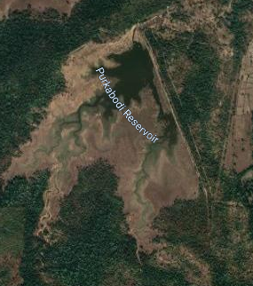
Map & link uploaded Aug - Sept 2020.
Official Designation of Purkabodi Dam Irrigation Project is " Purkabodi Dam , D - 04656 " . However local and popular name is " Purkabodi Lake / Purkabodi Talav ". Purkabodi Dam was constructed as part of irrigation projects by Government of Maharashtra the year of completion of the project is not known. It is built on and impounds a Local nallah , city to dam is Bhandara in Bhandara District of Maharashtra . The dam is an Earth fill Dam .The Length of dam is 1107 m ( 3631.89 Feet ) , while the Height of the dam above lowest foundation is 20.34 m ( 66.7322 feet ) . Information about Project Spillway is not known. Dam's catchment area is not known . Maximum / Gross storage capacity is 1.46 MCM. Live storage capacity is 1.42 MCM. Now a days almost all the water bodies make for good picnic spots. Purkabodi Lake is also a popular Tourist attraction for its scenic beauty.
(Note : Blue area in normal map corresponds to Maximum / Full Reservoir Level.)
3.Kumbhali ( LATITUDE : 21.0479771N, LONGITUDE : 79.9863696E )
3.Kumbhali ( LATITUDE : 21.0479771N, LONGITUDE : 79.9863696E )
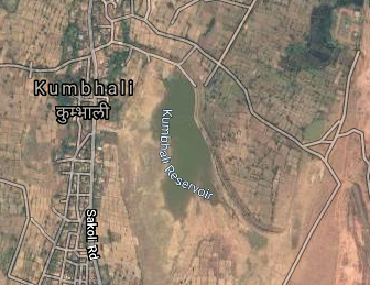
Map & link uploaded Aug - Sept 2020.
Official Designation of Kumbhali Dam Irrigation Project is " Kumbhali Dam , D - 04740 " . However local and popular name is " Kumbhali Lake / Kumbhali Talav ". Kumbhali Dam was constructed by the Britishers during the British Raj in 1907. It is built on and impounds a Chulbandh River . Nearest city to dam is Sakoli in Bhandara District of Maharashtra . The dam is an Earth fill Dam .The Length of dam is 1330 m ( 4363.517 ft ) , while the Height of the dam above lowest foundation is 11 m ( 36.089 feet ) . Project has no proper spillway as such.Length of the spillway is not known. The Dam has ungated Spillway. Dam's catchment area is not known . Maximum / Gross storage capacity is 0.76 MCM. Live storage capacity is 0,74 MCM. Now a days almost all the water bodies make for good picnic spots. Kumbhali Lake is also a popular Tourist attraction for its scenic beauty .
(Note : Blue area in normal map corresponds to Maximum / Full Reservoir Level.)
4.Rawanwadi ( LATITUDE : 21.038885N, LONGITUDE : 79.7272253E )
4.Rawanwadi ( LATITUDE : 21.038885N, LONGITUDE : 79.7272253E )
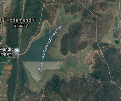
Map & link uploaded Aug - Sept 2020.
For viewing the surrounding areas and the map page click HERE.
Some information about Rawanwadi Irrigation Project.Official Designation of Rawanwadi Dam Irrigation Project is " Rawanwadi Dam , D - 04708 " . However local and popular name is " Rawanwadi Lake / Rawanwadi Talav ". Rawanwadi Dam was constructed as part of irrigation projects by Government of Maharashtra in the year 1960. It is built on and impounds a Local nallah , Nearest city to dam is Bhandara in Bhandara District of Maharashtra . The dam is an Earth fill Dam .The Length of dam is 96 m ( 314.961 Feet ) , while the Height of the dam above lowest foundation is 12.44 m ( 40.8136 feet ) . Project has no proper spillway as such.Length of the spillway is not known. The Dam has ungated .Dam's catchment area is not known . Maximum / Gross storage capacity is 6.9 MCM. Live storage capacity is 8.75 MCM. Now a days almost all the water bodies make for good picnic spots. Rawanwadi Lake is also a popular Tourist attraction for its scenic beauty .Hilly terrain and forest adds to the natural beauty.
(Note : Blue area in normal map corresponds to Maximum / Full Reservoir Level.)
5.Silli Ambadi ( LATITUDE : 21.1128172N, LONGITUDE : 79.6678305E )
5.Silli Ambadi ( LATITUDE : 21.1128172N, LONGITUDE : 79.6678305E )

Map & link uploaded Aug - Sept 2020.
For viewing the surrounding areas and the map page click HERE.
Some information about Silli Ambadi Irrigation Project.Official Designation of Silli Ambadi Dam Irrigation Project is " Silli Ambadi Dam , D - 0485 " . However local and popular name is " Silli Ambadi Lake / Silli Ambadi Talav ". Silli Ambadi Dam was constructed as part of irrigation projects by Government of Maharashtra the year of completion of the project is not known.. It is built on and impounds a Local nallah , Nearest city to dam is Bhandara in Bhandara District of Maharashtra . The dam is an Earth fill Dam .The Length of dam is 1380 m ( 4527.559 Feet ) , while the Height of the dam above lowest foundation is 12.82 m ( 42.0603 feet ) . Project has no proper spillway as such.Length of the spillway is not known. The Dam has ungated Spillway. Dam's catchment area is not known Maximum / Gross storage capacity is 1.27 MCM. Live storage capacity is 1.22 MCM. Now a days almost all the water bodies make for good picnic spots. Silli Ambadi Lake is also a popular Tourist attraction for its scenic beauty .
(Note : Blue area in normal map corresponds to Maximum / Full Reservoir Level.)]
6 Gandhari ( LATITUDE : 21.1015771N, LONGITUDE : 79.9228334E )

Map & link uploaded Aug - Sept 2020.
For viewing the surrounding areas and the map page click HERE.
Some information about Gandhari Irrigation Project.There are two dams with the same name in Maharashtra .This is one, the other one is near Lonar town in Buldhana District
Official Designation of Gandhari Dam Irrigation Project is " Gandhari Dam , D - 03813 " . However local and popular name is " Gandhari Lake / Gandharii Talav ".Gandhari Irrigation Project is constructed as part of irrigation project by the Government of Maharashtra. It was completed in 1982. It is built on a Local Nallah near city of Sakoli in Bhandara District of Maharashtra . The dam is an Earth fill dam .The length of dam is 1002 m ( 3287.40 ft ) , while the height of the dam above lowest foundation is 10.08 m ( 33.071 feet ) . Project has a no proper Spillway of any type.Length of the spillway is not known.Its catghment area is not known . Maximum / Gross storage capacity is 1.9 MCM. Live storage capacity is 1.83 MCM. Now a days almost all the water bodies make for good picnic spots and so does this place.
(Note : Blue area in normal map corresponds to Maximum / Full Reservoir Level.)
7.Rengepar Kotha ( LATITUDE : 21.1171259N, LONGITUDE : 79.8285753E )

Map & link uploaded Aug - Sept 2020.
For viewing the surrounding areas and the map page click HERE.
Some information about Rengepar Kotha Irrigation Project.Official Designation of Rengepar Kotha Dam Irrigation Project is " Rengepar Kotha Dam , D - 03269 " . However local and popular name is " Rengepar Kotha Lake / Rengepar Kotha Gram Talav ". Rengepar Kotha Dam was constructed as part of irrigation projects by Government of Maharashtra in the year 1976. It is built on and impounds a Local nallah , Nearest city to dam is Sakoli inBhandara District of Maharashtra . The dam is an Earth fill Dam .The Length of dam is 1034 m ( 3392.388 Feet ) , while the Height of the dam above lowest foundation is 10.18 m ( 33.3989 feet ) . Project has no proper spillway as such.Length of the spillway is not known. The Dam has ungated Spillway. .Dam's catchment area is not known . Maximum / Gross storage capacity is 3.03 MCM. Live storage capacity is 2.88 MCM. Now a days almost all the water bodies make for good picnic spots. Rengepar Kotha Lake is also a popular Tourist attraction for its scenic beauty .
(Note : Blue area in normal map corresponds to Maximum / Full Reservoir Level.)
8.Amgaon ( LATITUDE : 21.1404085N, LONGITUDE : 79.7482967E )

Map & link uploaded Aug - Sept 2020.
For viewing the surrounding areas and the map page click HERE.
Some information about Amgaon Irrigation Project.Official Designation of Amgaon Dam Irrigation Project is " Amgaon Dam , D - 03290 " . However local and popular name is " Amgaon Lake / Amgaon Talav ". Ambagad Dam was constructed as part of irrigation projects by Government of Maharashtra in the year 1961. It is built on and impounds Mahur River. Nearest city to dam is Bhandara in Bhandara District of Maharashtra . The dam is an Earth fill Dam .The Length of dam is 704.08 m ( 2309.9737 Feet ) , while the Height of the dam above lowest foundation is 10.45 m ( 34.2847 feet ) . Project has no proper spillway as such.Length of the spillway is not known. The Dam has ungated Spillway. Dam's catchment area is not known Maximum / Gross storage capacity is 0.91 MCM. Live storage capacity is 0.87 MCM. Now a days almost all the water bodies make for good picnic spots. Amgaon Lake is also a popular Tourist attraction for its scenic beauty .
(Note : Blue area in normal map corresponds to Maximum / Full Reservoir Level.)
9.Dadanzari ( LATITUDE : 21.155658N, LONGITUDE : 79.7571588E )
9.Dadanzari ( LATITUDE : 21.155658N, LONGITUDE : 79.7571588E )

Map & link uploaded Aug - Sept 2020.
For viewing the surrounding areas and the map page click HERE.
Some information about Dadanzari Irrigation Project.Official Designation of Dadanzari Dam Irrigation Project is " Dadanzari Dam , D - 03584 " . However local and popular name is " Dadanzari Lake / Dadanzari Talav ". Dadanzari Dam was constructed as part of irrigation projects by Government of Maharashtra in the year 1974. It is built on and impounds a Local nallah , Nearest city to dam is Bhandara in Bhandara District of Maharashtra . The dam is an Earth fill Dam .The Length of dam is 1030 m ( 3379.265 Feet ) , while the Height of the dam above lowest foundation is 10.91 m ( 35.7939 feet ) . Project has no proper spillway as such.Length of the spillway is not known. The Dam has ungated Spillway.Dam's catchment area is not known Maximum / Gross storage capacity is 1.3 MCM. Live storage capacity is 1.23 MCM. Now a days almost all the water bodies make for good picnic spots. Dadanzari Lake is also a popular Tourist attraction for its scenic beauty .
(Note : Blue area in normal map corresponds to Maximum / Full Reservoir Level.)
10.Betekar Bothali ( LATITUDE : 21.4277432N, LONGITUDE : 79.5494485E )
10.Betekar Bothali ( LATITUDE : 21.4277432N, LONGITUDE : 79.5494485E )

Map & link uploaded Aug - Sept 2020.
For viewing the surrounding areas and the map page click HERE.
Some information about Betekar Bothali Irrigation Project.Official Designation of Betekar Bothali Dam Irrigation Project is " Betekar Bothali Dam , D - 01386 " . However local and popular name is " Betekar Bothali Lake / Betekar Bothali Talav ". Betekar Bothali Dam was constructed as part of irrigation projects by Government of Maharashtra in the year 1978. It is built on and impounds Gawansola River .Nearest city to dam is Tumsar in Bhandara District of Maharashtra . The dam is an Earth fill Dam .The Length of dam is 510 m ( 1673.23 Feet ) , while the Height of the dam above lowest foundation is 20.7 m ( 67.9133 feet ) . Project has a spillway of other type . Length of the spillway is not known. Dam has 1 other type of spillway gate. Dam has a catchment area of 2.743 Thousand Hactors. Maximum / Gross storage capacity is 4.156 MCM. Live storage capacity is 3.666 MCM. Now a days almost all the water bodies make for good picnic spots. Betekar Bothali Lake is also a popular Tourist attraction for its scenic beauty .
(Note : Blue area in normal map corresponds to Maximum / Full Reservoir Level.)
No comments:
Post a Comment