DAMS IN YAVATMAL DISTRICT - PART ONE. (EDITED)
All 33 blogs covering 380 dams in 11 Districts of Vidarbha Region were edited between Aug & Sept 2020. For details go to blog "Vidarbha Region. Edit-Now - Why". Link here.
There are total of 59 Major Dams ( Height from foundation 10 meters or more ) in Yavatmal District. Information on these parts is covered in Five Parts.
Part One. 1.Bembla. 2.Sirasgaon. 3.Lohatwadi. 4. Ner. 5.Kapara. 6.Takali. 7. Zola. 8.Borgaon.
7. Zola. 8.Borgaon. 9.Ghoti.10.Duttapur. 11.Rajur. 12.Durug. 13.Pimpalkhuti.
Part Two 14.Warud. 15.Anji. 16. Bhulgad. 17. Antargaon. 18.Jamwadi. 19.Nilona. 20. Kharad. 21.Ghatana. 22.Chapdoh. 23.Waghadi. 24.Kumbharkinhi. 25.Kumbharkini. 26.Goki.
27.Wardh.
Part Three. 28.Vihirgaon. 29.Khemkund. 30.Munzala / Munjala. 31. Karanji. 32. Dhdhana,
33.Chorkund. 33.Chorkund.34.Arunawati. 35.Saikheda. 36.Wai. 37.Nawargaon.
38.Khandani. 39.Maisdodak.
Part
Four. 40.Muchi.41. Rampur. 42. Borda. 43. Rasa. 44. Kharda
Barrage. 45.Kinhi.
46.Nandgavhan. 47.Rui. 48.Upper
Pus (Pus). 49. Lower Pus. 50.Khadakdoh.
Part
Five. 51.Jambnala. 52.Senad. 53.Mudana. 54.Pimpalgaon. 55.Pophali. 56. Marsul.57.Nignoor. 58.Piranji. 59.Darati .
1.Bembla. ( Latitude : 20.5086311N, Longitude : 77.7217484E )

Map & link uploaded Aug - Sept 2020.
For viewing the surrounding areas and map page click here.
Some information about Bembla Irrigation Project.
However information about the Project:
The Bembla major irrigation project is being constructed in Yavatmal District of Maharashtra state. The project envisages construction of 7203 m long earthenand Masonary dam with a maximum height of 19.06 m and 447 m long masonry/concrete dam having the maximum height of 29.15 m with 297 m long central spillway having 20 radial gates, each of size 12 X 8 m across river Bembla near Khadak - Sawanga in Babhulgaon taluka of Yavatmal District. The project also includes 115 km long Right Bank Canal with distribution network and Dehani Lift Irrigation Scheme (LIS). The annual irrigation potential of the project is 52543 Ha. (47,000 Ha. By flow and 5543 Ha. by lift) in Yavatmal District.The CCA of the project is 60528 hectare.
Present Status:
March 2007, 96% main dam, 35% works on the main canal/branch canals, 10% works of Distributaries and Minors, part works of Dehani Lift Irrigation Scheme were complete. The project is planned to be completed by 2013-14.This Government projection does not seem to be correct and there may be time over runs.
Following is Edit on 7 September 2020.
Latest Status based on web site (https://numerical.co.in/- Status of Bembla Irrigation Project in Vidarbha)
This gives progress at various stages till 24 Decenber 2019.
Jan Manch and other social organizations visit the project and report while the dam is complete, the distribution network is not. The Ralegaon mail and sub-main canal, while constructed, do not have lining which will result in water seepage and hence wastage. A minor canal from Mengapur to Waldur, built 10 years ago, has never been used and was found to be filled with mud and vegetation!
2.Sirasgaon. ( Latitude : 20.5086311N, Longitude : 77.7217484E )

Map & link uploaded Aug - Sept 2020.
For viewing the surrounding areas and map page click here.
Some information about Sirasgaon Irrigation Project.
Official Designation of Sirasgaon Dam Irrigation Project is " Sirasgaon Dam , D -04850 " . However local and popular name is " Sirasgaon Lake / Sirasgaon " . Sirasgaon Dam was constructed as part of Irrigation Projects by the Government of Maharashtra in the year 1973. It is built on and impounds a local Nallah . Nearest city to dam is Ner in Yavatmal District of Maharashtra . The dam is an Earth fill Dam .The purpose of the dam is for Irrigation .The Length of dam is 600 m ( 1968.5 Feet ) , while the Height of the dam above lowest foundation is 21.12 m ( 69.2913 Feet ) . Any type of information about the Project Spillway is not available at all. . Length of the spillway is not known. The Dam has ungated spillway. Dam's catchment area is not known . Maximum / Gross storage capacity is 9.134 MCM. Live storage capacity is 8.342 MCM. Now a days almost all the water bodies make for good picnic spots Sirasgaon Lake is also a popular picnic spot for its scenic beauty .
(Note : Blue area in normal map corresponds to Maximum / Full Reservoir Level.)

Map & link uploaded Aug - Sept 2020.
For viewing the surrounding areas and map page click here.
Some information about Lohatwadi Irrigation Project.
Official Designation of Lohatwadi Dam Irrigation Project is " Lohatwadi Dam , D -04260 " . However local and popular name is " Lohatwadi Lake / Lohatwadi Talav " . Lohatwadi Dam was constructed as part of Irrigation Projects by the Government of Maharashtra in the year 1978. It is built on and impounds a local Nallah . Nearest city to dam is Ner in Yavatmal District of Maharashtra . The dam is an Earth fill Dam .The purpose of the dam is for Irrigation .The Length of dam is 447 m ( 1466.54 Feet ) , while the Height of the dam above lowest foundation is 12.3 m ( 40.3543 Feet ) . Any type of information about the Project Spillway is not available at all. Length of the spillway is not known. The Dam has ungated spillway. Dam's catchment area is not known . Maximum / Gross storage capacity is 1.9 MCM. Live storage capacity is 1.01 MCM. Now a days almost all the water bodies make for good picnic spots Lohatwadi Lake is also a popular picnic spot for its scenic beauty .
(Note : Blue area in normal map corresponds to Maximum / Full Reservoir Level.)

Map & link uploaded Aug - Sept 2020.
For viewing the surrounding areas and map page click here.
Some information about Ner Irrigation Project.
Official Designation of Ner Dam Irrigation Project is " Ner Dam , D -04446 " . However local and popular name is " Ner Lake / Ner Talav " .Ner Dam was constructed as part of Irrigation Projects by the Government of Maharashtra in the year 1978. It is built on and impounds a local Nallah . Nearest city to dam is Ner in Yavatmal District of Maharashtra . The dam is an Earth fill Dam .The purpose of the dam is for Irrigation .The Length of dam is 625 m ( 2050.52 Feet ) , while the Height of the dam above lowest foundation is 11.89 m ( 39.0091 Feet ) . Any type of information about the Project Spillway is not available at all. Length of the spillway is not known. The Dam has ungated spillway. Dam's catchment area is not known . Maximum / Gross storage capacity is 3.067 MCM. Live storage capacity is 3.067 MCM. Now a days almost all the water bodies make for good picnic spots Ner Lake is also a popular picnic spot for its scenic beauty .
(Note : Blue area in normal map corresponds to Maximum / Full Reservoir Level.)

Map & link uploaded Aug - Sept 2020.
For viewing the surrounding areas and map page click here.
Some information about Kapara Irrigation Project.
Official Designation of Kapara Dam Irrigation Project is " Kapara Dam , D -04060 " . However local and popular name is " Kapara Lake / Kapara Talav " . Kapara Dam was constructed as part of Irrigation Projects by the Government of Maharashtra in the year 1974. It is built on and impounds a local Nallah . Nearest city to dam is Babhulgaon in Yavatmal District of Maharashtra . The dam is an Earth fill Dam .The purpose of the dam is for Irrigation . The Length of dam is 505 m ( 1656.82 Feet ) , while the Height of the dam above lowest foundation is 18.9 m ( 62.00781 Feet ) . Any type of information about the Project Spillway is not available at all. Length of the spillway is not known. The Dam has ungated spillway. .Dam's catchment area is not known . Maximum / Gross storage capacity is 3.37 MCM. Live storage capacity is 3.054 MCM. Now a days almost all the water bodies make for good picnic spots Kapara Lake is also a popular picnic spot for its scenic beauty .
(Note : Blue area in normal map corresponds to Maximum / Full Reservoir Level.)

Map & link uploaded Aug - Sept 2020.
For viewing the surrounding areas and map page click here.
Some information about Takali Irrigation Project.
There are four dams with the name Takli .1.near Khamgaon in Buldhana District .2. near Yavatmal in Yavatmal District. 3. near Chandur Rly in Amravati District and 4. near Kultabad in Aurangabad District .
Official Designation of Takali Dam Irrigation Project is " Takali Dam , D -01290 " . However local and popular name is " Takali Lake / Takali Talav " . Takali Dam was constructed as part of Irrigation Projects by the Government of Maharashtra in the year 1995. It is built on and impounds a local Nallah River . Nearest city to dam is Yavatmal in Yavatmal District of Maharashtra . The dam is an Earth fill Dam .The purpose of the dam is for Irrigation.The Dam is built in two parts, total Length of dam is 773 m ( 2536.09 Feet ) , while the Height of the dam above lowest foundation is 21.6 m ( 70.866 Feet ) . Any type of information about the Project Spillway is not available at all. Length of the spillway is not known. The Dam has ungated spillway. Dam's catchment area is not known .Maximum / Gross storage capacity is 5.39 MCM. Live storage capacity is 4.78 MCM. Now a days almost all the water bodies make for good picnic spots Takali Lake is also a popular picnic spot for its scenic beauty .
Official Designation of Takali Dam Irrigation Project is " Takali Dam , D -01290 " . However local and popular name is " Takali Lake / Takali Talav " . Takali Dam was constructed as part of Irrigation Projects by the Government of Maharashtra in the year 1995. It is built on and impounds a local Nallah River . Nearest city to dam is Yavatmal in Yavatmal District of Maharashtra . The dam is an Earth fill Dam .The purpose of the dam is for Irrigation.The Dam is built in two parts, total Length of dam is 773 m ( 2536.09 Feet ) , while the Height of the dam above lowest foundation is 21.6 m ( 70.866 Feet ) . Any type of information about the Project Spillway is not available at all. Length of the spillway is not known. The Dam has ungated spillway. Dam's catchment area is not known .Maximum / Gross storage capacity is 5.39 MCM. Live storage capacity is 4.78 MCM. Now a days almost all the water bodies make for good picnic spots Takali Lake is also a popular picnic spot for its scenic beauty .
(Note : Blue area in normal map corresponds to Maximum / Full Reservoir Level.)

Map & link uploaded Aug - Sept 2020.
For viewing the surrounding areas and map page click here.
Some information about Zola Irrigation Project.
Official Designation of Zola Dam Irrigation Project is " Zola Dam , D -05099 " . However local and popular name is " ZolaLake / ZolaTalav " . Zola Dam was constructed as part of Irrigation Projects by the Government of Maharashtra in the year 1985. It is built on and impounds a local Nallah . Nearest city to dam is Babhulgaon in Yavatmal District of Maharashtra . The dam is an Earth fill Dam .The purpose of the dam is for Irrigation.The Length of dam is 534 m ( 1751.97 Feet ) , while the Height of the dam above lowest foundation is 18.18 m ( 59.6456 Feet ) . Any type of information about the Project Spillwayis not available at all. . Length of the spillway is not known. The Dam has ungated spillway. Dam's catchment area is not known . Maximum / Gross storage capacity is 2.156 MCM. Live storage capacity is 2.093 MCM. Now a days almost all the water bodies make for good picnic spots Zola Lake is also a popular picnic spot for its scenic beauty .
(Note : Blue area in normal map corresponds to Maximum / Full Reservoir Level.)

Map & link uploaded Aug - Sept 2020.
For viewing the surrounding areas and map page click here.
Some information about Borgaon Irrigation Project.
There are five dams with the name Borgaon .1.near Malegaon in Washim District .2. near borgaonl in Yavatmal District. Other three Borgaons are suffixed with place names
Official Designation of Borgaon Dam Irrigation Project is " Borgaon Dam , D -02847 " . However local and popular name is " Borgaon Lake / Borgaon Talav " . Borgaon Dam was constructed as part of Irrigation Projects by the Government of Maharashtra in the year 1993. It is built on and impounds a local Nallah River . Nearest city to dam is Yavatmal in Yavatmal District of Maharashtra . The dam is an Earth fill Dam .The purpose of the dam is for Irrigation.The Length of dam is 830 m ( 2723.1 Feet ) , while the Height of the dam above lowest foundation is 20 m ( 65.6168 Feet ) . Any type of information about the Project Spillway is not available at all. Project has no proper spillway as such . Length of the spillway is not known. The Dam has ungated spillway. .Dam's catchment area is not known . Maximum / Gross storage capacity is 2.38 MCM. Live storage capacity is 12.224 MCM. Now a days almost all the water bodies make for good picnic spots Borgaon Lake is also a popular picnic spot for its scenic beauty .
Official Designation of Borgaon Dam Irrigation Project is " Borgaon Dam , D -02847 " . However local and popular name is " Borgaon Lake / Borgaon Talav " . Borgaon Dam was constructed as part of Irrigation Projects by the Government of Maharashtra in the year 1993. It is built on and impounds a local Nallah River . Nearest city to dam is Yavatmal in Yavatmal District of Maharashtra . The dam is an Earth fill Dam .The purpose of the dam is for Irrigation.The Length of dam is 830 m ( 2723.1 Feet ) , while the Height of the dam above lowest foundation is 20 m ( 65.6168 Feet ) . Any type of information about the Project Spillway is not available at all. Project has no proper spillway as such . Length of the spillway is not known. The Dam has ungated spillway. .Dam's catchment area is not known . Maximum / Gross storage capacity is 2.38 MCM. Live storage capacity is 12.224 MCM. Now a days almost all the water bodies make for good picnic spots Borgaon Lake is also a popular picnic spot for its scenic beauty .
(Note : Blue area in normal map corresponds to Maximum / Full Reservoir Level.)

Map & link uploaded Aug - Sept 2020.
For viewing the surrounding areas and map page click here.
Some information about Ghoti Irrigation Project.
Official Designation of Ghoti Dam Irrigation Project is " Ghoti Dam , D -03873 " . However local and popular name is " Ghoti Lake / Ghoti Talav " . Ghoti Dam was constructed as part of Irrigation Projects by the Government of Maharashtra in the year 1974. It is built on and impounds a local Nallah . Nearest city to dam is Kalamb in Yavatmal District of Maharashtra . The dam is an Earth fill Dam .The purpose of the dam is for Irrigation.The Length of dam is 470 m ( 1541.99 Feet ) , while the Height of the dam above lowest foundation is 15.21 m ( 49.9015 Feet ) . Any type of information about the Project Spillway is not available at all. . Length of the spillway is not known. The Dam has ungated spillway. Dam's catchment area is not known .The Dam's catchment area is 5.115 Thousand Hectors . Maximum / Gross storage capacity is 2.35 MCM. Live storage capacity is 2.07 MCM. Now a days almost all the water bodies make for good picnic spots Ghoti Lake is also a popular picnic spot for its scenic beauty .
(Note : Blue area in normal map corresponds to Maximum / Full Reservoir Level.)
10.Duttapur. ( Latitude : 20.4074662N, Longitude : 78.3223486E)

Map & link uploaded Aug - Sept 2020.
For viewing the surrounding areas and map page click here.
Some information about Ghoti Irrigation Project.
Official Designation of Dattapur Dam Irrigation Project is " Dattapur Dam , D -03608 " . However local and popular name is " Dattapur Lake / Dattapur Talav " . Dattapur Dam was constructed as part of Irrigation Projects by the Government of Maharashtra in the year 1991. It is built on and impounds a local Nallah River . Nearest city to dam is Kalamb in Yavatmal District of Maharashtra . The dam is an Earth fill Dam .The purpose of the dam is for Irrigation.The Length of dam is 404 m ( 1325.46Feet ) , while the Height of the dam above lowest foundation is 15.18 m ( 49.8031 Feet ) . Any type of information about the Project Spillway is not available at all. . Length of the spillway is not known. The Dam has ungated spillway. .Dam's catchment area is not known . Maximum / Gross storage capacity is 1.68 MCM. Live storage capacity is 1.6 MCM. Now a days almost all the water bodies make for good picnic spots Dattapur Lake is also a popular picnic spot for its scenic beauty .
(Note : Blue area in normal map corresponds to Maximum / Full Reservoir Level.)
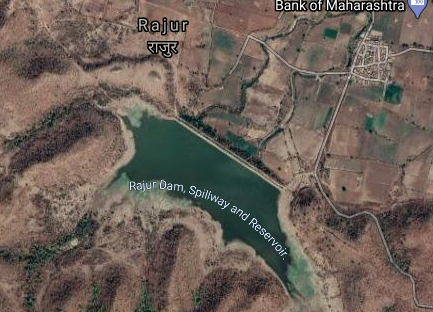
Map & link uploaded Aug - Sept 2020.
For viewing the surrounding areas and map page click here.
Some information about Rajur Irrigation Project.
Official Designation of Rajur Dam Irrigation Project is " Rajur Dam , D -04677 " . However local and popular name is " Rajur Lake / Rajur Talav " . Rajur Dam was constructed as part of Irrigation Projects by the Government of Maharashtra in the year 1990 . It is built on and impounds a local Nallah . Nearest city to dam is Kalamb in Yavatmal District of Maharashtra . The dam is an Earth fill Dam.The purpose of the dam is for Irrigation,The Length of dam is 617 m ( 2024.28 Feet ) , while the Height of the dam above lowest foundation is 17.02 m ( 55.8398 Feet ) . Any type of information about the Project Spillway is not available at all. Length of the spillway is not known. The Dam has ungated spillway. Dam's catchment area is not known . Maximum / Gross storage capacity is 2.29 MCM. Live storage capacity is 2.19 MCM. Now a days almost all the water bodies make for good picnic spots Rajur Lake is also a popular picnic spot for its scenic beauty .
(Note : Blue area in normal map corresponds to Maximum / Full Reservoir Level.)

Map & link uploaded Aug - Sept 2020.
For viewing the surrounding areas and map page click here.
Some information about Durug Irrigation Project.
Official Designation of Durug Dam Irrigation Project is " Durug Dam , D -03772 " . However local and popular name is " Durug Lake / Durug Talav " . Durug Dam was constructed as part of Irrigation Projects by the Government of Maharashtra in the year 1967. It is built on and impounds a local Nallah . Nearest city to dam is Kalamb in Yavatmal District of Maharashtra . The dam is an Earth fill Dam .The purpose of the dam is for Irrigation,The Length of dam is 503 m ( 1650.26 Feet ) , while the Height of the dam above lowest foundation is 15.55 m ( 51.0170 Feet ) . Any type of information about the Project Spillway is not available at all. Project has no proper spillway as such . Length of the spillway is not known. The Dam has ungated spillway. Dam's catchment area is not known Maximum / Gross storage capacity is 3.59 MCM. Live storage capacity is 3.25 MCM. Now a days almost all the water bodies make for good picnic spots Durug Lake is also a popular picnic spot for its scenic beauty .
(Note : Blue area in normal map corresponds to Maximum / Full Reservoir Level.)

Map & link uploaded Aug - Sept 2020.
For viewing the surrounding areas and map page click here.
Some information about Pimpalkhuti Irrigation Project.
Official Designation of Pimpalkhuti Dam Irrigation Project is " Pimpalkhuti Dam , D -04598 " . However local and popular name is " Pimpalkhuti Lake / Pimpalkhuti / Talav " . Pimpalkhuti Dam was constructed as part of Irrigation Projects by the Government of Maharashtra in the year 1974. It is built on and impounds a local Nallah . Nearest city to dam is Ralegaon in Yavatmal District of Maharashtra . The dam is an Earth fill Dam .The purpose of the dam is for Irrigation,.The Length of dam is 640 m ( 2099.74 Feet ) , while the Height of the dam above lowest foundation is 16 m ( 52.4934 Feet ) . Any type of information about the Project Spillway is not available at all.. Length of the spillway is not known. The Dam has ungated spillway..Dam's catchment area is not known . Maximum / Gross storage capacity is 2.38 MCM. Live storage capacity is 2.237 MCM. Now a days almost all the water bodies make for good picnic spots Pimpalkhuti Lake is also a popular picnic spot for its scenic beauty
Official Designation of Pimpalkhuti Dam Irrigation Project is " Pimpalkhuti Dam , D -04598 " . However local and popular name is " Pimpalkhuti Lake / Pimpalkhuti / Talav " . Pimpalkhuti Dam was constructed as part of Irrigation Projects by the Government of Maharashtra in the year 1974. It is built on and impounds a local Nallah . Nearest city to dam is Ralegaon in Yavatmal District of Maharashtra . The dam is an Earth fill Dam .The purpose of the dam is for Irrigation,.The Length of dam is 640 m ( 2099.74 Feet ) , while the Height of the dam above lowest foundation is 16 m ( 52.4934 Feet ) . Any type of information about the Project Spillway is not available at all.. Length of the spillway is not known. The Dam has ungated spillway..Dam's catchment area is not known . Maximum / Gross storage capacity is 2.38 MCM. Live storage capacity is 2.237 MCM. Now a days almost all the water bodies make for good picnic spots Pimpalkhuti Lake is also a popular picnic spot for its scenic beauty
(Note : Blue area in normal map corresponds to Maximum / Full Reservoir Level.)
New Approved dam project in yavatmal district
ReplyDeleteName and details Please.
ReplyDelete