DAMS IN GADCHIROLI DISTRICT. (EDITED)
There are total of 05 Major Dams ( Height from foundation 10 meters or more ) in Gadchiroli District. Details about these five dams are covered here,
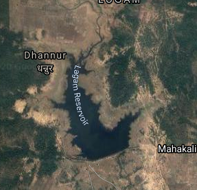
1.Lagam ( LATITUDE : 19.5624186N, LONGITUDE : 79.8942518E)
1.Lagam ( LATITUDE : 19.5624186N, LONGITUDE : 79.8942518E)
Map & link uploaded Aug - Sept 2020.
For viewing the surrounding areas and the map page click here.
Some information about Lagam Irrigation ProjectOfficial Designation of Lagam Dam Irrigation Project is " Lagam Dam , D - 04238 " . However local and popular name is " Lagam Lake / Lagam Talav ". Lagam Dam was constructed as part of irrigation projects by Government of Maharashtra in the year 1984. It is built on and impounds a Local nallah , Nearest city to dam is Charmoshi in Gadchiroli District of Maharashtra . The dam is an Earth fill Dam .The Length of dam is 1549.4 m ( 5083.3333 ft ) , while the Height of the dam above lowest foundation is 12.5 m (41.010 feet ) . Project has no proper spillway as such. Length of the spillway is not known. The Dam has ungated Spillway. .Dam's catchment area is not known Maximum / Gross storage capacity is 3.73 MCM. Live storage capacity is 3.42 MCM. Now a days almost all the water bodies make for good picnic spots. Lagam Lake is also a popular Tourist attraction for its scenic beauty.
(Note : Blue area in normal map corresponds to Maximum / Full Reservoir Level.)
2.Kamalapur ( LATITUDE : 19.2019776N, LONGITUDE : 80.1927066E )
Map & link uploaded Aug - Sept 2020.
For viewing the surrounding areas and the map page click here.
Some information about Kamalapur Irrigation Project.Official Designation of Kamalapur Dam Irrigation Project is " Kamalapur Dam , D - 04046 " . However local and popular name is " Kamalapur Lake / Kamalapur Talav ". Kamalapur Dam was constructed as part of irrigation projects by Government of Maharashtra in the year 1974. It is built on and impounds a Local nallah , Nearest city to dam is Gadchiroli in Gadchiroli District of Maharashtra . The dam is an Earth fill Dam .The Length of dam is 743 m ( 2437.66 ft ) , while the Height of the dam above lowest foundation is 11.8 m ( 38.713 feet ). Project has no proper spillway as such..Length of the spillway is not known. The Dam has ungated Spillway. Dam's catchment area is not known . Maximum / Gross storage capacity is 1.884 MCM. Live storage capacity is 1.643 MCM. However when this satellite shot was taken the water level in Kamalapur Lake seems to be very low, almost a dried up lake. A sorry sight.
(Note : Blue area in normal map corresponds to Maximum / Full Reservoir Level.)
3.Dina ( LATITUDE : 19.7590299N, LONGITUDE : 80.1201153E )

Map & link uploaded Aug - Sept 2020.
For viewing the surrounding areas and the map page click here.
Some information about Dina Irrigation Project.Official Designation of Dina Dam Irrigation Project is " Dina Dam , D - 01326 " . However local and popular name is " Dina Lake / DinaTalav ". Dina Dam was constructed as part of irrigation projects by Government of Maharashtra in the year 1974. It is built on and impounds Dina River . Nearest city to dam is Charmoshi in Gadchiroli District of Maharashtra . The dam is an Earth fill Dam .The Length of dam is 3137 m ( 10291.99 ft ) , while the Height of the dam above lowest foundation is 21.49 m ( 70.5052 feet ) . Project has a spillway of Ogee type.Length of the spillway is 122 m ( 400.262 feet ) The Dam has ungated Spillway.. Dam has a catchment area of 19.3 Thousand Hactors. Maximum / Gross storage capacity is 72.5 MCM. Live storage capacity is 67.54 MCM. Now a days almost all the water bodies make for good picnic spots. Dina Lake is also a popular Tourist attraction for its scenic beauty . Hilly Terrain and forest add further ti the beauty.
(Note : Blue area in normal map corresponds to Maximum / Full Reservoir Level.)
4.Karwappa Dam. ( Latitude : 20.1357767N, Longitide : 80.1857711E )
4.Karwappa Dam. ( Latitude : 20.1357767N, Longitide : 80.1857711E )

Map & link uploaded Aug - Sept 2020.
Map location as given in wiki. Seems something is wrong here. Location if right in the centre of Sakhera Village of Dhanora Talika, Gadchiroli District. to see surrounding area click here.
Following information including , about the dam from wiki.
Karwappa Dam, is an earthfill dam on Karwappa river near Gadchiroli in state of Maharashtra in India.
Impounds Karwappa RiverThe height of the dam above lowest foundation is 35 m (115 ft) while the length is 1,416 m (4,646 ft). The volume content is 991 km3 (238 cu mi) and gross storage capacity is 32,560.00 km3 (7,811.56 cu mi).
Purpose of the dam is for irrigation. 5.Pentipakka ( LATITUDE : 18.785265,N, LONGITUDE : 80.031323E )

Map & link uploaded Aug - Sept 2020.
For viewing the surrounding areas and the map page click here.
Some information about Pentipakka Irrigation Project
Official Designation of Pentipakka Dam Irrigation Project is " Pentipakka Dam , D - 04568 " . However local and popular name is " Pentipakka Lake / Pentipakka Talav ". Pentipakka Dam was constructed as part of irrigation projects by Government of Maharashtra in the year 1977. It is built on and impounds a Local nallah . Nearest city to dam isGsdchiroli in Gadchiroli District of Maharashtra . The dam is an Earth fill Dam .The Length of dam is 638 m ( 2093.18 ft ) , while the Height of the dam above lowest foundation is 11.79 m ( 38.6811 feet ) . Project has no proper spillway as such.Length of the spillway is not known. The Dam has ungated Spillway. Dam's catchment area is not known Maximum / Gross storage capacity is 0.883 MCM. Live storage capacity is 0.535 MCM. Now a days almost all the water bodies make for good picnic spots However Pentipakka Lake seems to be the exception as almost all the water has gone and the lake is almost dry . A sad sight .
(Note : Blue area in normal map corresponds to Maximum / Full Reservoir Level.)
No comments:
Post a Comment