DAMS IN WASHIM DISTRICT - PART FOUR. (EDITED)
All 33 blogs covering 380 dams in 11 Districts of Vidarbha Region were edited between Aug & Sept 2020. For details go to blog "Vidarbha Region. Edit-Now - Why". Link here.
There are total of 53 Major Dams ( Height from foundation 10 meters or more ) in Washim District.
Information on these parts is covered in Five Parts.
Part One. 1.Zodga. 2.Adan. 3.Gartek. 4.Chousala. 5. hanora Bhuse. 6.Mohari.
7. Bramhanwada 1. 8. Bramhanwada 2. 9.Pimpari (Kd). 10.Ridhora. 11.Sukhanda/Sukanda.
Part Two. 12.Sonkhas. 13. Rohana. 14.Asola. 15.Wathod. 16.Borwa. 17.Karli.
18.Borala. 19.Mungala. 20.Kalmeshwar. 21.Motsawanga. 22.Kolambi. 23.Gid.
Part Three. 24.Masala Kd. 25.Sawanga. 26.Giroli. 27.Chikhali. 28.Sawargaon. 29.Koyali.
30.Sonala/Sonal. 31.Asegaonbandh. 32.Asolagavha. 33.Panchala. 34.Amdari. 35.Waigoul.
Part Four. 36.Gondala/Gaundhala. 37.Ratanwadi. 38.Rui. 39.Fulmari. 40.Umra Sm. 41. Adol. 42.Waghi.43.Dhodho. 44.Ekburji. 45.Dhumka. 46.Shirputi.
Part Five. 47.Warala. 48.Ansing. 49.Karada. 50.Ganeshpur. 51.Pachamba. 52.Mandwa.
53.Jawala. .
36.Gondala/Gaundhala. ( Latitude : 20.1209425N, Longitude : 76.6805577E )

Map & link uploaded Aug - Sept 2020.
For viewing the surrounding areas and map page click here.
Some information about Gondala/Gaundhala Irrigation Project.
Gondala - also spelt as - Gaundhala. Gondala Project and Dam's Official Designation is Gondala, D - 0 3883" . Locally also known as " Gondala Lake" / "Gondala Talav" . Gondala Dam was constructed as part of irrigation projects by Government of Maharashtra in the year 1996 . Nearest city to dam is Risod and the Dam is situated in Risod Taluka of Washim District of Maharashtra . It is built on and impounds a Local Nallah .The dam is an Earth-fill Gravity Dam . Purpose of the dam is for irrigation . The length of the dam is 1207 m ( 3959.97 Feet ) while the height of the dam above lowest foundation is 11.9 m ( 39.04 Feet ) . Detailed information about project spillway is not available . However , Project appears to have a Spillway of Other type . Length of the spillway is not known . However measured length of the spillway is approximately 90 m ( 296 Feet ) . The Spillway is Ungated . Dam's catchment area is not known . Maximum / Gross storage capacity is 2.614 MCM . Live storage capacity is 2.147 MCM. Now a days almost all the water bodies make for good picnic spots Gondala lake is also a popular Tourist attraction for its scenic beauty .
(Note : Blue area in normal map corresponds to Maximum / Full Reservoir Level.)
(Note : Blue area in normal map corresponds to Maximum / Full Reservoir Level.)
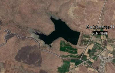
37.Ratanwadi. ( Latitude : 20.1137494N, Longitude : 77.5322127E )
Map & link uploaded Aug - Sept 2020.
For viewing the surrounding areas and map page click here.
Some information about Ratanwadi Irrigation Project.
Ratanwadi Project and Dam's Official Designation is Ratanwadi, D - 0 4703" . Locally also known as " Ratanwadi Lake" / "Ratanwadi Talav" . Ratanwadi Dam was constructed as part of irrigation projects by Government of Maharashtra in the year 1976 . Nearest city to dam is Manora and the Dam is situated in Manora Taluka of Washim District of Maharashtra . It is built on and impounds a Local Nallah . The dam is an Earth-fill Gravity Dam . Purpose of the dam is for irrigation . The length of the dam is 380 m ( 1246.72 Feet ) while the height of the dam above lowest foundation is 19 m ( 62.33 Feet ) . Detailed information about project spillway is not available . However , Project appears to have a Spillway of Other type . At least whatever is left of what was once a Spillway , is in a bad condition being eroded and partly washed away . spillway canal exists . Dam's catchment area is not known . Maximum / Gross storage capacity is 1.33 MCM . Live storage capacity is 1.22 MCM. Now a days almost all the water bodies make for good picnic spots Ratanwadi lake is also a popular Tourist attraction for its scenic beauty .
(Note : Blue area in normal map corresponds to Maximum / Full Reservoir Level.)
(Note : Blue area in normal map corresponds to Maximum / Full Reservoir Level.)
38.Rui. ( Latitude : 20.1140013N, Longitude : 77.4579155E )

Map & link uploaded Aug - Sept 2020.
For viewing the surrounding areas and map page click here.
Some information about Rui Irrigation Project.
Rui Project and Dam's Official Designation is " Rui, D - 0 4723" . Locally also known as " Rui Lake" / " Rui Talav" . Rui Dam was constructed as part of irrigation projects by Government of Maharashtra in the year 1986 . Nearest city to dam is Manora and the Dam is situated in Manora Taluka of Washim District of Maharashtra . It is built on and impounds a Local Nallah . The dam is an Earth-fill Gravity Dam . Purpose of the dam is for irrigation . The length of the dam is 326 m ( 1069.55 Feet ) while the height of the dam above lowest foundation is 19.15 m ( 62.82 Feet ) . Detailed information about project spillway is not available . However , Project appears to have a Spillway of Other type . Length of the spillway is not known . However measured length of the spillway is approximately 34 m ( 110 Feet ) .The Spillway is Ungated . Dam's catchment area is not known . Maximum / Gross storage capacity is 0.952 MCM . Live storage capacity is 0.849 MCM. Now a days almost all the water bodies make for good picnic spots Rui lake is also a popular Tourist attraction for its scenic beauty .
(Note : Blue area in normal map corresponds to Maximum / Full Reservoir Level.)
(Note : Blue area in normal map corresponds to Maximum / Full Reservoir Level.)
39.Fulmari. ( Latitude : 20.089206N, Longitude : 77.5431776E )

Map & link uploaded Aug - Sept 2020.
For viewing the surrounding areas and map page click here.
Some information about Fulmari Irrigation Project.
Fulmari it is also spelt as " Fulumari " .
Fulmari Project and Dam's Official Designation is " Fulmari D - 0 3780" . Locally also known as " Fulmari Lake" / " Fulmari Talav" . Fulmari Dam was constructed as part of irrigation projects by Government of Maharashtra in the year 1980 . Nearest city to dam is Manora and the Dam is situated in Manora Taluka of Washim District of Maharashtra . It is built on and impounds a Local Nallah .The dam is an Earth-fill Gravity Dam . Purpose of the dam is for irrigation . The length of the dam is 527 m ( 1729 Feet ) while the height of the dam above lowest foundation is 17.5 m ( 57.41 Feet ) . Detailed information about project spillway is not available . However , Presently the dam does not have a proper spillway at all . At least today there are no traces of a proper spillway . At least whatever is left of what was once a Spillway , is in a very bad condition being eroded and partly washed away and only spillway canal exists Dam's catchment area is not known . Maximum / Gross storage capacity is 1.26 MCM . Live storage capacity is 1.19 MCM. Now a days almost all the water bodies make for good picnic spots Fulmari lake is also a popular Tourist attraction for its scenic beauty .
(Note : Blue area in normal map corresponds to Maximum / Full Reservoir Level.)
40.Umra Sm. ( Latitude : 20.0948284N, Longitude : 77.2720814E )

Map & link uploaded Aug - Sept 2020.
For viewing the surrounding areas and map page click here.
Some information about Umra Sm Irrigation Project.
Umra Sm is an abbreviation . Full form of the name "Umra Sm" is " UmraShamshuddin " it is also spelt as " UmraSmamsuddin, "
Umra Sm Project and Dam's Official Designation is " Umra Sm D - 0 4961" . Locally also known as " Umra Lake" / " Umra Talav" . Umra Sm Dam was constructed as part of irrigation projects by Government of Maharashtra in the year 1996. Nearest city to dam is Washim and the Dam is situated in Washim Taluka of Washim District of Maharashtra . It is built on and impounds a Local Nallah .The dam is an Earth-fill Gravity Dam . Purpose of the dam is for irrigation . The length of the dam is 1270 m ( 4166.66 Feet ) while the height of the dam above lowest foundation is 13.3 m ( 43.63 Feet ) . Detailed information about project spillway is not available . Project Spillway length is not known . However measured length of the spillway is 65 m ( 205 Feet ) The spill way is of Ogee type . The spill way appears un-gated . Dam's catchment area is not known . Maximum / Gross storage capacity is 2.477 MCM . Live storage capacity is 1.991 MCM. Now a days almost all the water bodies make for good picnic spots Umra Sm lake is also a popular Tourist attraction for its scenic beauty .
Umra Sm Project and Dam's Official Designation is " Umra Sm D - 0 4961" . Locally also known as " Umra Lake" / " Umra Talav" . Umra Sm Dam was constructed as part of irrigation projects by Government of Maharashtra in the year 1996. Nearest city to dam is Washim and the Dam is situated in Washim Taluka of Washim District of Maharashtra . It is built on and impounds a Local Nallah .The dam is an Earth-fill Gravity Dam . Purpose of the dam is for irrigation . The length of the dam is 1270 m ( 4166.66 Feet ) while the height of the dam above lowest foundation is 13.3 m ( 43.63 Feet ) . Detailed information about project spillway is not available . Project Spillway length is not known . However measured length of the spillway is 65 m ( 205 Feet ) The spill way is of Ogee type . The spill way appears un-gated . Dam's catchment area is not known . Maximum / Gross storage capacity is 2.477 MCM . Live storage capacity is 1.991 MCM. Now a days almost all the water bodies make for good picnic spots Umra Sm lake is also a popular Tourist attraction for its scenic beauty .
(Note : Blue area in normal map corresponds to Maximum / Full Reservoir Level.)
41. Adol. ( Latitude :20.0999669N, Longitude :76.9802999E )

Map & link uploaded Aug - Sept 2020.
For viewing the surrounding areas and map page click here.
Some information about Adol Irrigation Project.
Official name of the Project is Adol Irrigation Project , most probably because the dam is built across Adola River . However locally and more commonly it is known as Borala Dam .
Adol Project and Dam's Official Designation is " Adol D - 0 3255" . Locally also known as " Borala Lake" / " Borala Talav " . Adol Dam was constructed as part of irrigation projects by Government of Maharashtra in the year 1990 Nearest city to dam is Borala and the Dam is situated in Malegaon Taluka of Washim District of Maharashtra . It is built on and impounds Adola River .The dam is an Earth-fill Gravity Dam . Purpose of the dam is for irrigation . The dam is divided in two portions by the Spillway. The portion Left ( Western Side ) of the spillway is 1292 m ( 4238.83 Feet ) + The portion Right ( Eastern Side ) of the spillway is 273 m ( 895.66 Feet ) . The Total length of the Dam , including the Spillway is 1725 m ( 5659.44 Feet ) . while the height of the dam above lowest foundation is 18.47 m ( 60.59 Feet ) . Detailed information about project spillway is not available . Project Spillway length is not known . However , measured length of the spillway is 160 m ( 524.93 Feet ) . The spill way appears to be of Other Type . The spill way appears un-gated Dam's catchment area is not known . Maximum / Gross storage capacity is 15.27 MCM . Live storage capacity is not known . Now a days almost all the water bodies make for good picnic spots Adol lake is also a popular Tourist attraction for its scenic beauty .
(Note : Blue area in normal map corresponds to Maximum / Full Reservoir Level.)

Map & link uploaded Aug - Sept 2020.
For viewing the surrounding areas and map page click here.
Some information about Waghi Irrigation Project.
Waghi Project and Dam's Official Designation is " Waghi D - 0 5034" . Locally also known as " Waghi Lake" / " Waghi Talav" . Waghi Dam was constructed as part of irrigation projects by Government of Maharashtra in the year 1980. Nearest city to dam is Risod and the Dam is situated in Risod Taluka of Washim District of Maharashtra . It is built on and impounds a Local Nallah . The dam is an Earth-fill Gravity Dam . Purpose of the dam is for irrigation . The length of the dam is 762 m ( 2500 Feet ) while the height of the dam above lowest foundation is 14.9 m ( 48.88 Feet ) . Detailed information about project spillway is not available . Project Spillway length is not known . However , measured length of the spillway is 108 m ( 354 Feet ) . The spill way appears to be Other Type . The spill way appears un-gated . Dam's catchment area is not known .Gross storage capacity is 2.8 MCM . Live storage capacity is 2.6 MCM. Now a days almost all the water bodies make for good picnic spots Waghi lake is also a popular Tourist attraction for its scenic beauty .
(Note : Blue area in normal map corresponds to Maximum / Full Reservoir Level.)
(Note : Blue area in normal map corresponds to Maximum / Full Reservoir Level.)
43.Dhodho. ( Latitude : 20.0843493N, Longitude : 76.717186E )

Map & link uploaded Aug - Sept 2020.
For viewing the surrounding areas and map page click here.
Some information about Dhodho Irrigation Project.
Dhodho Project and Dam's Official Designation is " Dhodho D - 03680" . Locally also known as " Dhodho Lake" / " Dhodho Talav" . Dhodho Dam was constructed as part of irrigation projects by Government of Maharashtra in the year 1998. Nearest city to dam is Risod and the Dam is situated in Risod Taluka of Washim District of Maharashtra . It is built on and impounds a Local Nallah .The dam is an Earth-fill Gravity Dam . Purpose of the dam is for irrigation . The dam is divided in two portions by the Spillway. The portion Left ( Western Side ) of the spillway is 295 m ( 967.84 Feet ) + The portion Right ( Eastern Side ) of the spillway is 760 m ( 2493.44 Feet ) . The Total length of the Dam , including the Spillway is 1122 m ( 3681.10 Feet ) . while the height of the dam above lowest foundation is 10.86 m ( 35.62 Feet ) . Detailed information about project spillway is not available . Project Spillway length is not known . However , measured length of the spillway is 67 m ( 219.81 Feet ) . The spill way appears to be Other Type . The spill way appears un-gated type. Dam's catchment area is not known . Maximum / Gross storage capacity is 1.794 MCM . Live storage capacity is 1.65 MCM. Now a days almost all the water bodies make for good picnic spots Dhodho lake is also a popular Tourist attraction for its scenic beauty .
(Note : Blue area in normal map corresponds to Maximum / Full Reservoir Level.)
44.Ekburji. ( Latitude : 20.0457015N, Longitude : 77.1006453E )

Map & link uploaded Aug - Sept 2020.
For viewing the surrounding areas and map page click here.
Some information about Ekburji Irrigation Project.
Ekburji Project and Dam's Official Designation is " Ekburji D - 0 1207" . Locally also known as " Ekburji Lake" / " Ekburji Talav" . Ekburji Dam was constructed as part of irrigation projects by Government of Maharashtra in the year 1964. Nearest city to dam is Washim and the Dam is situated in Washim Taluka of Washim District of Maharashtra . It is built on and impounds Chandrabhaga River .The dam is an Earth-fill Gravity Dam . Purpose of the dam is for irrigation . The length of the dam is 830 m ( 2723.1 Feet ) while the height of the dam above lowest foundation is 23.7 m ( 77.75 Feet ) . Detailed information about project spillway is not available . Project Spillway length is not known . However , measured length of the spillway is 149 m ( 490 Feet ) . The spill way appears to be Other Type . The spill way appears un-gated type. The Spillway is in bad condition being eroded and partly washed away . Dam's catchment area is not known . Maximum / Gross storage capacity is 14.1 MCM . Live storage capacity is 11.96 MCM. Now a days almost all the water bodies make for good picnic spots Ekburji lake is also a popular Tourist attraction for its scenic beauty .
(Note : Blue area in normal map corresponds to Maximum / Full Reservoir Level.)
(Note : Blue area in normal map corresponds to Maximum / Full Reservoir Level.)

Map & link uploaded Aug - Sept 2020.
For viewing the surrounding areas and map page click here.
Some information about Dhumka Irrigation Project.
Dhumka Project and Dam's Official Designation is " Dhumka D - 0 3699" . Locally also known as " Dhumka Lake" / " Dhumka Talav" . Dhumka Dam was constructed as part of irrigation projects by Government of Maharashtra in the year 1999. Nearest city to dam is Washim and the Dam is situated in Washim Taluka of Washim District of Maharashtra . It is built on and impounds a Local Nallah .The dam is an Earth-fill Gravity Dam . Purpose of the dam is for irrigation . The length of the dam is 967 m ( 3172.57 Feet ) while the height of the dam above lowest foundation is 14.38 m ( 47.17 Feet ) . Detailed information about project spillway is not available . Project Spillway length is not known . However , measured length of the spillway is 97 m ( 319 Feet ) . The spill way appears to be Other Type . The spill way appears un-gated type. Dam's catchment area is not known . Maximum / Gross storage capacity is 3.064 MCM . Live storage capacity is 2.788 MCM. Now a days almost all the water bodies make for good picnic spots Dhumka lake is also a popular Tourist attraction for its scenic beauty .
(Note : Blue area in normal map corresponds to Maximum / Full Reservoir Level.)
(Note : Blue area in normal map corresponds to Maximum / Full Reservoir Level.)

Map & link uploaded Aug - Sept 2020.
For viewing the surrounding areas and map page click here.
Some information about Shirputi Irrigation Project.
Shirputi Project and Dam's Official Designation is " Shirputi D - 0 4826" . Locally also known as " Shirputi Lake" / " Shirputi Talav" . Shirputi Dam was constructed as part of irrigation projects by Government of Maharashtra in the year 1971. Nearest city to dam is Washim and the Dam is situated in Washim Taluka of Washim District of Maharashtra . It is built on and impounds a Local Nallah .The dam is an Earth-fill Gravity Dam . Purpose of the dam is for irrigation . The length of the dam is 355 m ( 1164.7 Feet ) while the height of the dam above lowest foundation is 19.35 m ( 63.48 Feet ) . Detailed information about project spillway is not available . Project Spillway length is not known . However , measured length of the spillway is 68 m ( 224 Feet ) . Presently whatever is left of what was once a Spillway , is in a very bad condition being eroded and partly washed away . Dam's catchment area is not known . Maximum / Gross storage capacity is 2.22 MCM . Live storage capacity is 1.93 MCM. Now a days almost all the water bodies make for good picnic spots Shirputi lake is also a popular Tourist attraction for its scenic beauty .
(Note : Blue area in normal map corresponds to Maximum / Full Reservoir Level.)
(Note : Blue area in normal map corresponds to Maximum / Full Reservoir Level.)
No comments:
Post a Comment