DAMS IN WASHIM DISTRICT - PART ONE (EDITED)
All 33 blogs covering 380 dams in 11 Districts of Vidarbha Region were edited between Aug & Sept 2020. For details go to blog "Vidarbha Region. Edit-Now - Why". Link here.
There are total of 53 Major Dams ( Height from foundation 10 meters or more ) in Washim District.
Information on these parts is covered in Five Parts.
Part One. 1.Zodga. 2.Adan. 3.Gartek. 4.Chousala. 5. hanora Bhuse. 6.Mohari.
7. Bramhanwada 1. 8. Bramhanwada 2. 9.Pimpari (Kd). 10.Ridhora. 11.Sukhanda/Sukanda.
Part Two. 12.Sonkhas. 13. Rohana. 14.Asola. 15.Wathod. 16.Borwa. 17.Karli.
18.Borala. 19.Mungala. 20.Kalmeshwar. 21.Motsawanga. 22.Kolambi. 23.Gid.
Part Three. 24.Masala Kd. 25.Sawanga. 26.Giroli. 27.Chikhali. 28.Sawargaon. 29.Koyali.
30.Sonala/Sonal. 31.Asegaonbandh. 32.Asolagavha. 33.Panchala. 34.Amdari. 35.Waigoul.
Part Four. 36.Gondala/Gaundhala. 37.Ratanwadi. 38.Rui. 39.Fulmari. 40.Umra
Sm. 41. Adol. 42.Waghi.43.Dhodho. 44.Ekburji. 45.Dhumka. 46.Shirputi.
Part Five. 47.Warala. 48.Ansing. 49.Karada. 50.Ganeshpur. 51.Pachamba. 52.Mandwa.
53.Jawala.
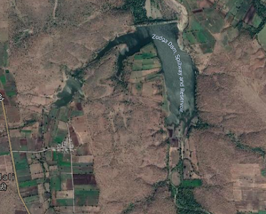
1.Zodga. ( Latitude : 20.4445463N, Longitude : 77.2029877E )
Map & link uploaded Aug - Sept 2020.
For viewing the surrounding areas and map page click here.
Some information about Zodga Irrigation Project.
Zodga Project and Dam's Official Designation is "Zodga , D -0 5098" . Locally also known as " Zodga Lake" / " Zodga Talav" . Zodga Dam was constructed as part of irrigation projects by Government of Maharashtra in the year 1984 . Nearest city to dam is Zodga and the Dam is situated in Karanja Taluka of Washim District of Maharashtra . It is built on and impounds a local Nallah . The dam is an Earth-fill Gravity Dam .Purpose of the dam is for irrigation . The length of the dam is 578 m ( 1896.33 Feet ) . while the height of the dam above lowest foundation is 13.71 m ( 44.98 Feet ) . Detailed information about project spillway is not available However Project Spillway seems to have been washed away quire badly . Dam's catchment area is not known . Maximum / Gross storage capacity is 1.14 MCM . Live storage capacity is not known. Now a days almost all the water bodies make for good picnic spots. Zodga lake is also a popular Tourist attraction for its scenic beauty .
(Note : Blue area in normal map corresponds to Maximum / Full Reservoir Levels)
2.Adan. ( Latitude : 20.4116493N, Longitude : 77.5601292E )

Map & link uploaded Aug - Sept 2020.
For viewing the surrounding areas and map page click here.
Some information about Adan Irrigation Project.
In Marathi it is " अरण " and in English spelt as "Adan" .
Adan Project and Dam's Official Designation is "Adan , D -0 3189" . Locally also known as " Adan Lake" / " Adan Talav" . Adan Dam was constructed as part of irrigation projects by Government of Maharashtra in the year 1977. Nearest city to dam is Karanja and the Dam is situated in Karanja Taluka of Washim District of Maharashtra . It is built on and impounds a local Aran River ,. The dam is an Earth-fill Gravity Dam .Purpose of the dam is for irrigation . The length of the dam is 755 m ( 2477.03 Feet ) while the height of the dam above lowest foundation is 30.3 m ( 99.40 Feet ) . Project has a Spillway of Ogee type . Length of the spillway is 72 m ( 236.22 Feet ). The Spillway is gated The Spillway has 05 Radial Type of spillway gates . Dam's catchment area is 79.8 Thousand Hectors . Maximum / Gross storage capacity is 78.32 MCM . Live storage capacity is 67.25 MCM. Now a days almost all the water bodies make for good picnic spots. Adan lake is also a popular Tourist attraction for its scenic beauty .
(Note : Blue area in normal map corresponds to Maximum / Full Reservoir Levels)
3.Gartek. ( Latitude : 20.3566979N, Longitude : 77.5445724E )

Map & link uploaded Aug - Sept 2020.
For viewing the surrounding areas and map page click here.
Some information about Gartek Irrigation Project.
Gartek Project and Dam's Official Designation is "Gartek , D -0 3829" . Locally also known as " Gartek Lake" / " Gartek Talav" . Gartek Dam was constructed as part of irrigation projects by Government of Maharashtra in the year 1995 . Nearest city to dam is Manora and the Dam is situated in Manora Taluka of Washim District of Maharashtra . It is built on and impounds a local Nallah . The dam is an Earth-fill Gravity Dam .Purpose of the dam is for irrigation . The length of the dam is 354 m ( 1161.42 Feet ) . while the height of the dam above lowest foundation is 18.08 m ( 59.31 Feet ) . Detailed information about project spillway is not available . Project Spillway type is not known. Length of the spillway is not known . The Spillway is Ungated . Dam's catchment area is not known . Maximum / Gross storage capacity is 1.993 MCM . Live storage capacity is 1.874 MCM. Now a days almost all the water bodies make for good picnic spots. Gartek lake is also a popular Tourist attraction for its scenic beauty .
(Note : Blue area in normal map corresponds to Maximum / Full Reservoir Levels)
4.Chousala. ( Latitude : 20.3564364N, Longitude : 77.5580907E )

Map & link uploaded Aug - Sept 2020.
For viewing the surrounding areas and map page click here.
Some information about Chousala Irrigation Project.
Chousala Project and Dam's Official Designation is "Chousala , D -0 3582" . Locally also known as " Chousala Lake" / " Chousala Talav" . Chousala Dam was constructed as part of irrigation projects by Government of Maharashtra in the year 1997 . Nearest city to dam is Manora and the Dam is situated in Manora Taluka of Washim District of Maharashtra . It is built on and impounds a local Nallah . The dam is an Earth-fill Gravity Dam .Purpose of the dam is for irrigation . The length of the dam is 298 m ( 977.69 Feet) . while the height of the dam above lowest foundation is 13.61 m ( 44.65 Feet ) . Detailed information about project spillway is not available . However . Project appears to have a Spillway of Other type . Length of the spillway is not known . However measured length of the spillway is approximately 51 m ( 168 Feet ). The Spillway is Ungated . Dam's catchment area is not known . Maximum / Gross storage capacity is 1.726 MCM . Live storage capacity is 1.59 MCM. Now a days almost all the water bodies make for good picnic spots . Chousala lake is also a popular Tourist attraction for its scenic beauty .
(Note : Blue area in normal map corresponds to Maximum / Full Reservoir Levels)
5. hanora Bhuse. ( Latitude : 20.3455122N, Longitude : 77.4982238E )


Bramhanwada Project and Dam's Official Designation is "Bramhanwada, D - 0 3510" . Locally also known as " Bramhanwada Lake" / "Bramhanwada Talav" . Bramhanwada Dam was constructed as part of irrigation projects by Government of Maharashtra in the year 1995. Nearest city to dam is Malegaon and the Dam is situated in Washim Taluka of Washim District of Maharashtra . It is built on and impounds a Local Nallah . The dam is an Earth-fill Gravity Dam . Purpose of the dam is for irrigation . The length of the dam is 275 m ( 902.23 Feet ) while the height of the dam above lowest foundation is 15.7 m ( 51.50 Feet ) . Detailed information about project spillway is not available . However , Project appears to have a Spillway of Other type . Length of the spillway is not known . However measured length of the spillway is approximately 34 m ( 113 Feet ). The Spillway is Ungated Dam's catchment area is not known . Maximum / Gross storage capacity is not known . Live storage capacity is not known . Now a days almost all the water bodies make for good picnic spots . Bramhanwada lake is also a popular Tourist attraction for its scenic beauty .
(Note : Blue area in normal map corresponds to Maximum / Full Reservoir Levels)

9.Pimpari (Kd). ( Latitude : 20.3091931N, Longitude : 77.2577691E )

10.Ridhora. ( Latitude : 20.3170211N, Longitude : 76.9446802E )

11.Sukhanda/Sukanda. ( Latitude : 20.286029N, Longitude : 77.0033455E )

Sukanda Project and Dam's Official Designation is "Sukhanda, D - 0 4878" . Locally also known as " Sukanda Lake" / " Sukanda Talav" . Sukanda Dam was constructed as part of irrigation projects by Government of Maharashtra in the year 1985 . Nearest city to dam is Manglur Pir and the Dam is situated in Malegaon Taluka of Washim District of Maharashtra . It is built on and impounds a local Nallah . The dam is an Earth-fill Gravity Dam .Purpose of the dam is for irrigation . The length of the dam is 972 m ( 3188.98 Feet ) while the height of the dam above lowest foundation is 15.3m (50.19Feet ) . Detailed information about project spillway is not available However , However , as on date, 30 Decemner 2012, there is no proper spillway .Portion of the dam and Spillway has been washed away but traces of Spillway are still visible at southern end of the dam . Dam's catchment area is not known . Maximum / Gross storage capacity is 2.57 MCM . Live storage capacity is 2.37 MCM. Now a days almost all the water bodies make for good picnic spots .Sukanda lake is also a popular Tourist attraction for its scenic beauty .
(Note : Blue area in normal map corresponds to Maximum / Full Reservoir Levels)
Chousala Project and Dam's Official Designation is "Chousala , D -0 3582" . Locally also known as " Chousala Lake" / " Chousala Talav" . Chousala Dam was constructed as part of irrigation projects by Government of Maharashtra in the year 1997 . Nearest city to dam is Manora and the Dam is situated in Manora Taluka of Washim District of Maharashtra . It is built on and impounds a local Nallah . The dam is an Earth-fill Gravity Dam .Purpose of the dam is for irrigation . The length of the dam is 298 m ( 977.69 Feet) . while the height of the dam above lowest foundation is 13.61 m ( 44.65 Feet ) . Detailed information about project spillway is not available . However . Project appears to have a Spillway of Other type . Length of the spillway is not known . However measured length of the spillway is approximately 51 m ( 168 Feet ). The Spillway is Ungated . Dam's catchment area is not known . Maximum / Gross storage capacity is 1.726 MCM . Live storage capacity is 1.59 MCM. Now a days almost all the water bodies make for good picnic spots . Chousala lake is also a popular Tourist attraction for its scenic beauty .
(Note : Blue area in normal map corresponds to Maximum / Full Reservoir Levels)
5. hanora Bhuse. ( Latitude : 20.3455122N, Longitude : 77.4982238E )
Map & link uploaded Aug - Sept 2020.
For viewing the surrounding areas and map page click here.
Some information about Dhanora Bhuse Irrigation Project.
Dhanora Bhuse Project and Dam's Official Designation is "Dhanora Bhuse , D - 0 3668" . Locally also known as " Dhanora Bhuse Lake" / " Dhanora Bhuse Talav" . Dhanora Bhuse Dam was constructed as part of irrigation projects by Government of Maharashtra in the year 1996. Nearest city to dam is Manora and the Dam is situated in Manora Taluka of Washim District of Maharashtra . It is built on and impounds a local Nallah . The dam is an Earth-fill Gravity Dam .Purpose of the dam is for irrigation . The length of the dam is 430 m ( 1410.76 Feet ) while the height of the dam above lowest foundation is 12.8 m ( 41.99 Feet ) . Detailed information about project spillway is not available However , Project appears to have a Spillway of Other type . Length of the spillway is not known . The Spillway is Ungated . Dam's catchment area is not known . Maximum / Gross storage capacity is not known Live storage capacity is not known . Now a days almost all the water bodies make for good picnic spots . Dhanora Bhuse lake is also a popular Tourist attraction for its scenic beauty .
(Note : Blue area in normal map corresponds to Maximum / Full Reservoir Levels)
6.Mohari. ( Latitude : 20.3498377N, Longitude : 77.4063635E )
Map & link uploaded Aug - Sept 2020.
For viewing the surrounding areas and map page click here.
Some information about Mohari Irrigation Project.
Some information about Mohari Irrigation Project.
Mohari Project and Dam's Official Designation is "Mohari , D - 0 4359" . Locally also known as " Mohari Lake" / " Mohari Talav" . Mohari Dam was constructed as part of irrigation projects by Government of Maharashtra in the year 1976 . Nearest city to dam is Manglur Pir and the Dam is situated in Manglur Pir Taluka of Washim District of Maharashtra . It is built on and impounds a local Nallah . The dam is an Earth-fill Gravity Dam .Purpose of the dam is for irrigation . The length of the dam is 550 m ( 1804.46 Feet ) while the height of the dam above lowest foundation is 10.44 m (34.25 Feet ) . Detailed information about project spillway is not available However , Project appears to have a Spillway of Other type . Length of the spillway is not known . However measured length of the spillway is approximately 55 m ( 179Feet ). The Spillway is Ungated . Dam's catchment area is not known . Maximum / Gross storage capacity is 1.53 MCM . Live storage capacity is 1.426 MCM. Now a days almost all the water bodies make for good picnic spots . Mohari lake is also a popular Tourist attraction for its scenic beauty .
(Note : Blue area in normal map corresponds to Maximum / Full Reservoir Levels)
7. Bramhanwada 1. ( Latitude : 20.1507386N, Longitude : 77.0493722E )
(Note : Blue area in normal map corresponds to Maximum / Full Reservoir Levels)
7. Bramhanwada 1. ( Latitude : 20.1507386N, Longitude : 77.0493722E )
Map & link uploaded Aug - Sept 2020.
For viewing the surrounding areas and map page click here.
Some information about Bramhanwada Irrigation Project.
There are two Dams with the name Bramhanwada both in Washim District. 1 Near Village Bramhanwada in Taluka Malegaon and
2, Near village Bramhanwada BK , also in Taluka. MalegaonBramhanwada Project and Dam's Official Designation is "Bramhanwada, D - 0 3510" . Locally also known as " Bramhanwada Lake" / "Bramhanwada Talav" . Bramhanwada Dam was constructed as part of irrigation projects by Government of Maharashtra in the year 1995. Nearest city to dam is Malegaon and the Dam is situated in Washim Taluka of Washim District of Maharashtra . It is built on and impounds a Local Nallah . The dam is an Earth-fill Gravity Dam . Purpose of the dam is for irrigation . The length of the dam is 275 m ( 902.23 Feet ) while the height of the dam above lowest foundation is 15.7 m ( 51.50 Feet ) . Detailed information about project spillway is not available . However , Project appears to have a Spillway of Other type . Length of the spillway is not known . However measured length of the spillway is approximately 34 m ( 113 Feet ). The Spillway is Ungated Dam's catchment area is not known . Maximum / Gross storage capacity is not known . Live storage capacity is not known . Now a days almost all the water bodies make for good picnic spots . Bramhanwada lake is also a popular Tourist attraction for its scenic beauty .
(Note : Blue area in normal map corresponds to Maximum / Full Reservoir Levels)
8. Bramhanwada 2. ( Latitude : 20.3273638N, Longitude : 76.9689488E )
Map & link uploaded Aug - Sept 2020.
For viewing the surrounding areas and map page click here.
Some information about Bramhanwada 2 Irrigation Project.
There are two Dams with the name Bramhanwada both in Washim District. 1 Near Village Bramhanwada in Taluka Malegaon and
2, Near village Bramhanwada BK , also in Taluka. Malegaon
Bramhanwada Project and Dam's Official Designation is "Bramhanwada, D - 0 3511" . Locally also known as " Bramhanwada Lake" / " Bramhanwada Talav" . Bramhanwada Dam was constructed as part of irrigation projects by Government of Maharashtra in the year 1998 . Nearest city to dam is Malegaon and the Dam is situated in Malegaon Taluka of Washim District of Maharashtra . It is built on and impounds a local Nallah . The dam is an Earth-fill Gravity Dam .Purpose of the dam is for irrigation . The length of the dam is 275 m ( 902.23 Feet ) while the height of the dam above lowest foundation is 15.7 m ( 51.50 Feet ) . Detailed information about project spillway is not available . However , Project appears to have a Spillway of Other type . Length of the spillway is not known . However measured length of the spillway is approximately 50 m ( 166 Feet ) The Spillway is Ungated . Dam's catchment area is not known . Maximum / Gross storage capacity is 1.107 MCM . Live storage capacity is 0.988 MCM. Now a days almost all the water bodies make for good picnic spots . Bramhanwada lake is also a popular Tourist attraction for its scenic beauty .
(Note : Blue area in normal map corresponds to Maximum / Full Reservoir Levels)
Map & link uploaded Aug - Sept 2020.
For viewing the surrounding areas and map page click here.
Some information about Pimpari (Kd)Irrigation Project.
Pimpari (Kd) Project and Dam's Official Designation is "Pimpari (Kd), D - 0 4609" . Locally also known as " Pimpari Lake" / " Pimpari Talav" . Pimpari (Kd) Dam was constructed as part of irrigation projects by Government of Maharashtra in the year 1980 . Nearest city to dam is Mangrul Pir and the Dam is situated in Mangrul Pir Taluka of Washim District of Maharashtra . It is built on and impounds Khanday River . The dam is an Earth-fill Gravity Dam .Purpose of the dam is for irrigation . The length of the dam is 555 m ( 1820.87 Feet ) while the height of the dam above lowest foundation is 15.2 m (49.21Feet ) . Detailed information about project spillway is not available However , Project appears to have a Spillway of Other type . Length of the spillway is not known . The Spillway is Ungated Dam's catchment area is not known . Maximum / Gross storage capacity is 1.46 MCM . Live storage capacity is 1.34 MCM. Now a days almost all the water bodies make for good picnic spots . Pimpari lake is also a popular Tourist attraction for its scenic beauty .
(Note : Blue area in normal map corresponds to Maximum / Full Reservoir Levels)
(Note : Blue area in normal map corresponds to Maximum / Full Reservoir Levels)
Map & link uploaded Aug - Sept 2020.
For viewing the surrounding areas and map page click here.
Some information about Ridhora Irrigation Project.
Ridhora Project and Dam's Official Designation is "Ridhora, D - 0 4713" . Locally also known as " Ridhora Lake" / " Ridhora Talav" . Locally it is also known as Medashi Dam, Medashi Talav due to proximity of village Madashi. Ridhora Dam was constructed as part of irrigation projects by Government of Maharashtra in the year 1981 . Nearest city to dam is Malegaon and the Dam is situated in Malegaon Taluka of Washim District of Maharashtra . It is built on and impounds a local Nallah . The dam is an Earth-fill Gravity Dam .Purpose of the dam is for irrigation . The length of the dam is 360 m ( 1181.1 Feet ) while the height of the dam above lowest foundation is 12.72 m ( 41.73 Feet ) .Detailed information about project spillway is not available However , The Project appears to have a Spillway of Other type . Length of the spillway is not known . However measured length of the spillway is approximately 171 m ( 560 Feet ) . The Spillway is Ungated . Dam's catchment area is not known . Maximum / Gross storage capacity is 1.087 MCM . Live storage capacity is 1.0 MCM. Now a days almost all the water bodies make for good picnic spots .Ridhora lake is also a popular Tourist attraction for its scenic beauty .
(Note : Blue area in normal map corresponds to Maximum / Full Reservoir Levels)
(Note : Blue area in normal map corresponds to Maximum / Full Reservoir Levels)
Map & link uploaded Aug - Sept 2020.
For viewing the surrounding areas and map page click here.
Some information about Sukhanda / Sukanda Irrigation Project.
Web site "india-wris.nrsc.gov.in/wrpinfo/index.php?title=Sukhanda..." is the only source where this place has been spelt as "Sukhanda" , this name will be used only as "Offocial". At all other sources the spelling given is "Sukanda".Sukanda Project and Dam's Official Designation is "Sukhanda, D - 0 4878" . Locally also known as " Sukanda Lake" / " Sukanda Talav" . Sukanda Dam was constructed as part of irrigation projects by Government of Maharashtra in the year 1985 . Nearest city to dam is Manglur Pir and the Dam is situated in Malegaon Taluka of Washim District of Maharashtra . It is built on and impounds a local Nallah . The dam is an Earth-fill Gravity Dam .Purpose of the dam is for irrigation . The length of the dam is 972 m ( 3188.98 Feet ) while the height of the dam above lowest foundation is 15.3m (50.19Feet ) . Detailed information about project spillway is not available However , However , as on date, 30 Decemner 2012, there is no proper spillway .Portion of the dam and Spillway has been washed away but traces of Spillway are still visible at southern end of the dam . Dam's catchment area is not known . Maximum / Gross storage capacity is 2.57 MCM . Live storage capacity is 2.37 MCM. Now a days almost all the water bodies make for good picnic spots .Sukanda lake is also a popular Tourist attraction for its scenic beauty .
(Note : Blue area in normal map corresponds to Maximum / Full Reservoir Levels)
No comments:
Post a Comment