DAMS IN WARDHA DISTRICT - PART ONE (EDITED).
All 33 blogs covering 380 dams in 11 Districts of Vidarbha Region were edited between Aug & Sept 2020. For details go to blog "Vidarbha Region. Edit-Now - Why". Link here.
There are total of 20 Major Dams ( Height from foundation 10 meters or more ) in Wardha District. Wardha District also has one Barrage Pulgaon). Excluded From dams coverage.
And two wiers ( Dham, Madan) These were researched and data included earlier. However during the edit their serial numbers were removed. And Dams renumbered In part one and two
Information on these dams is covered in Two Parts
Part One .1.Lal Nalla. 2. Pothara. 3. Pulgaon Barrage. 4. Rotha - I. 5. Rotha - II. 6. Madan. 7. Madan Pick Up Weir 8. Dham. 9. Dham Pick Up Weir. 10. Panchadhara. 11. Dongargaon. 12. Panjra Bothli.
Part Two 13. Sawangi. 14. Umri. 15. Bor. 16. Dahegaon ondi. 17. Ambazari. 18. Harashi. 19. Kannamwargram. 20. Kar. 21. Parsodi. 22. Asthi.
11. Sawangi. ( LATITUDE : 20.89494N, LONGITUDE : 78.3109546E )

Map & link uploaded Aug- Sept 2020.
Some information about Sawangi Irrigation Project.
( Note : Blue area in normal map corresponds to Maximum / Full Reservoir Level.)
12. Umri. ( LATITUDE : 20.9192745N, LONGITUDE : 78.4005833E )

For viewing the surrounding areas and the map page click HERE.
12. Umri. ( LATITUDE : 20.9192745N, LONGITUDE : 78.4005833E )

Map & link uploaded Aug- Sept 2020.
Some information about Umri Irrigation Project.
Umri Irrigation Project, The Dam's Official Designation is "Umri- D-04964" .There are two more projects with similar name , 1. Umri Dam -D-01271 near Saoner , Maharashtra and 2, Umri Tank -D-05721 in Gujrat .Umri Dam was constructed as part of irrigation projects by Government of Maharashtra in the year 1975 . It is built on Local nallah..nearest city to dam is Arvi in Wardha District of Maharashtra . The dam is an Earth fill The length of dam is 527 m ( 1729 ft ) , while the height of the dam above lowest foundation is 20.98 m ( 68.8320 feet ) . Project has a Spillway of Ogee type.Length of the spillway is not known. The spillway is un-gated.The Dam's catchment area is not known .Maximum / Gross storage capacity is 2.55 MCM. Live storage capacity is 2.4 MCM. Now a days almost all the water bodies make for good picnic spots Umri Lake is also a popular Place.
( Note : Blue area in normal map corresponds to Maximum / Full Reservoir Level.)
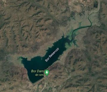
13. Bor. ( LATITUDE :20.9816362N, LONGITUDE : 78.7146378E )

Map & link uploaded Aug- Sept 2020.
For viewing the surrounding areas and the map page click HERE.


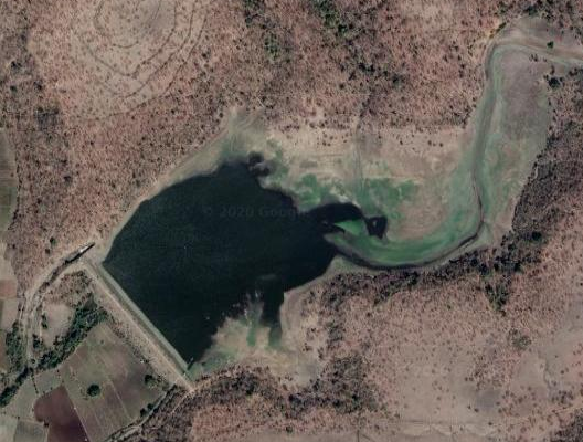
18. Kar. ( LATITUDE : 21.2222613N, LONGITUDE :78.4613085E )

19. Parsodi. ( LATITUDE : 21.2139N, LONGITUDE : 78.4285212E )

20. Asthi. ( LATITUDE : 21.2092291N, LONGITUDE : 78.1961346E )

Some information about Bor Irrigation Project.
Bor Irrigation Project, is located in Bor National Sanctuary and Tiger Reserve. Dam's Official Designation is "Bor, D-01225" .Bor Dam was constructed as part of irrigation projects by Government of Maharashtra in the year 1965 . It is built on Bor River , nearest city to dam is Bori in Wardha District of Maharashtra . The dam is an Earth fill Dam .The length of dam is 1158 m ( 3799.213 ft ) , while the height of the dam above lowest foundation is 36.28 m ( 119.028 feet ) . Project has a Spillway of Ogee type.Length of the spillway is 109.72 m ( 359.9737 ft ). .The Dam has 9 Radial Type of spillway gates.Dam's catchment area is 38.075 thousand hectors. Maximum / Gross storage capacity is 138.75 MCM. Live storage capacity is 127.42 MCM. Now a days almost all the water bodies make for good picnic spots. Bor Lake is also a popular Tourist attraction for its scenic beauty .Location in National Sanctuary is an added attraction.
( Note : Blue area in normal map corresponds to Maximum / Full Reservoir Level.)
14. Dahegaon Gondi. ( LATITUDE : 20.9507792N, LONGITUDE :78.4881306E )

Map & link uploaded Aug- Sept 2020.
For viewing the surrounding areas and the map page click HERE.
Some information about Dahegaon Gondi Irrigation Project.
Dahegaon Gondi Irrigation Project, Dam's Official Designation is "Dahegaon Gondi D-03589" .Dahegaon Gondi Dam was constructed as part of irrigation projects by Government of Maharashtra in the year 1984 . It is built on Local nallah , nearest city to dam is Wardha in Wardha District of Maharashtra . The dam is an Earth fill Dam .The length of dam is 410 m ( 1345.14 ft ) , while the height of the dam above lowest foundation is 16.8 m ( 55.1181 feet ) . Project has no proper spillway as such.Length of the spillway is not known. The spillway is un-gated . Dam's catchment area is not known . Maximum / Gross storage capacity is 3.24 MCM. Live storage capacity is 3.04 MCM. Now a days almost all the water bodies make for good picnic spots. Dahegaon Gondi Lake is also a popular Tourist attraction for its scenic beauty .
( Note : Blue area in normal map corresponds to Maximum / Full Reservoir Level.)
15. Ambazari. ( LATUTUDE : 20.9598366N, LONGITUDE :78.3196449E )

Map & link uploaded Aug- Sept 2020.
For viewing the surrounding areas and the map page click HERE.
Some information about Ambazari Irrigation Project.
Ambazari Irrigation Project, The Dam's Official Designation is "Ambazari D-03272" .There are two more lakes / dams with similar names ,1.Ambazari Project D 03273 Dam/lake NE of Bor Lake. 2.Ambazari Lake right in Nagpur City. This Project, Ambazari, Dam was constructed as part of irrigation projects by Government of Maharashtra in the year 1976 . It is built on Local nallah , nearest city to dam is Arvi in Wardhar District of Maharashtra . The dam is an Earth fill Dam .The length of dam is 726 m ( 2381.89 ft ) , while the height of the dam above lowest foundation is 14.9 m ( 48.8845 feet ) . Project has no proper spillway as such. Dam's catchment area is not known Maximum / Gross storage capacity is 2.23 MCM. Live storage capacity is 2.13 MCM. Now a days almost all the water bodies make for good picnic spots. Ambazari Lake is also a popular attraction for its scenic beauty .
( Note : Blue area in normal map corresponds to Maximum / Full Reservoir Level.)
16. Harashi. ( LATITUDE : 21.0489384N, LONGITUDE :78.3424115E )

Map & link uploaded Aug- Sept 2020.
For viewing the surrounding areas and the map page click HERE.
Some information about Harashi Irrigation Project.
Harashi Irrigation Project., the Dam's Official Designation is "Harashi D 03940." .Harashi Dam was constructed as part of irrigation projects by Government of Maharashtra in the year 1999 . It is built on Local nallah nearest city to dam is Wardha in Wardha District of Maharashtra . The dam is an Earth fill Dam .The length of dam is 384 m ( 1259.84 ft ) , while the height of the dam above lowest foundation is 17.36 m ( 56.9553 feet ) . Information on Project Spillway is not available. Dam's catchment area is not known .Maximum / Gross storage capacity is1.7 MCM. Live storage capacity is 1.4 MCM. Now a days almost all the water bodies make for good picnic spots. Harashi Lake is also a popular attraction for its scenic beauty .
( Note : Blue area in normal map corresponds to Maximum / Full Reservoir Level.)
17. Kannamwargram. ( LATITUDE : 21.0489384N, LONGITUDE :78.3424115E )

Map & link uploaded Aug- Sept 2020.
For viewing the surrounding areas and the map page click HERE.
Some information about Kannamwar Gram Irrigation Project.
Kannamwar Gram Irrigation Project, Locally "and Popularly known as " Kannamwar Gram Lake / Kannamwar Gram Talav". Dam's Official Designation is "Kannamwar Gram D-04059" .Kannamwar Gram Dam was constructed as part of irrigation projects by Government of Maharashtra in the year 1973 . It is built on Local nallah . Nearest city to dam is Wardha in Wardha District of Maharashtra . The dam is an Earth fill Dam .The length of dam is 375 m ( 1230.31 ft ) , while the height of the dam above lowest foundation is 16.7 m ( 54.79 feet ) . Project has no proper spillway as such . Length of the spillway is not known. The spillway is un-gated.Dam's catchment area is not known . Maximum / Gross storage capacity is 1.57 MCM. Live storage capacity is 1.46 MCM. Now a days almost all the water bodies make for good picnic spots.Kannamwar Gram Lake is also a popular Tourist attraction for its scenic beauty.
( Note : Blue area in normal map corresponds to Maximum / Full Reservoir Level.)

Map & link uploaded Aug- Sept 2020.
For viewing the surrounding areas and the map page click HERE.
Some information about Kar Irrigation Project.
Dam's Official Designation is "Kar D-03107" .Kar Dam was constructed as part of irrigation projects by Government of Maharashtra in the year 2000 . It is built on Kar River , nearest city to dam is Wardha in Wardha District of Maharashtra . The dam is an Earth fill Dam .The length of dam is 1067 m ( 3500.656 ft ) , while the height of the dam above lowest foundation is 25.13 m ( 82.4475 feet ) . Project has a Spillway of Ogee type . Length of the spillway is 267 m ( 875.984 ft ) The spillway is un-gated . The Dam' has catchment area of 17.612 thousand hectors. Maximum / Gross storage capacity is 25.963 MCM. Live storage capacity is 21.063 MCM. Now a days almost all the water bodies make for good picnic spots. Kar Lake is also a popular Tourist attraction for its scenic beauty . Lots of water sports and boating adds to the tourist enjoyment.
( Note : Blue area in normal map corresponds to Maximum / Full Reservoir Level.)

Map & link uploaded Aug- Sept 2020.
For viewing the surrounding areas and the map page click HERE.
Satellite view of Parsodi Dam and Reservoir uploaded in edit of 1 September 2020. The Dam and and Reservoir are not seen anywhere. The legend "Parsodi Dam and and Reservoir" printed in white vertical lettering confirms that it is indeed the correct location.
Some information about Parsodi Irrigation Project
Persodi Irrigation Project, The dam and reservoir is locally and Popularly known as " Persodi Lake / Persodi Talav ". Dam's Official Designation is "Persodi D 04569" . Persodi Dam was constructed as part of irrigation projects by Government of Maharashtra in the year 1982 . It is built on Local nallah , nearest city to dam is Wardha in Wardha District of Maharashtra . The dam is an Earth fill Dam .The length of dam is 169 m ( 554.462 ft ) , while the height of the dam above lowest foundation is 20.05 m ( 67.257 feet ) . Project has no proper spillway as such . Length of the spillway is not known .The catchment area of Dam is not known. Maximum / Gross storage capacity is 1.11 MCM. Live storage capacity is 1.07 MCM. Now a days almost all the water bodies make for good picnic spots. Persodi Lake is also a popular Tourist attraction for its scenic beauty .
( Note : Blue area in normal map corresponds to Maximum / Full Reservoir Level.)
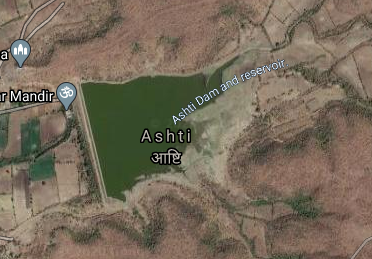
Map & link uploaded Aug- Sept 2020.
For viewing the surrounding areas and the map page click Here.
Some information about Asthi Irrigation Project
There are total of three Asthi dams in Maharashtra.one near Mahal in Solapur District.second near Asti in Bid District.& third this in Wardha District.
Official Designation of Ashti Dam Irrigation Project is " Ashti Dam , D - 03330 " . However local and popular name is " Kapileshwar Talav ".may be due to the Kapileshwar Temple built at the base of the Dam., Ashti Dam was constructed as parts of Irrigation Projects by the Government of Maharashtra in the year 1963 . It is built on and impounds a local Nallah . Nearest city to dam is Arvi in Wardha District of Maharashtra . The dam is an Earth Dam .The Length of dam is 589 m ( 1932.41 Feet ) , while the Height of the dam above lowest foundation is 17.31 m ( 56.7913 feet ) . Any type of information about the Project Spillway is not available at all . Dam's catchment area is not known . Maximum / Gross storage capacity is 1.71 MCM. Live storage capacity is 1.62 MCM. Now a days almost all the water bodies make for good picnic spots. Ashti Lake is also a popular Tourist attraction for its scenic beauty.
( Note : Blue area in normal map corresponds to Maximum / Full Reservoir Level.)
No comments:
Post a Comment