DAMS IN NAGPUR DISTRICT - PART FOUR.(EDITED}
All 33 blogs covering 380 dams in 11 Districts of Vidarbha Region were edited between Aug & Sept 2020. For details go to blog "Vidarbha Region. Edit-Now - Why". Link here.
There are total of 54 Major Dams ( Height from foundation 10 meters or more ) in Nagpur District. Kochi Barrage,(excluded in edit as only dms covered) Information on these dams is covered in FIVE parts.
Information on dams which are covered in each Part is given below.
Part One.1. Nagalwadi. 2. Khekranala. 3. Mahurkund. 4. Raibasa. 5. Nanda. 6. Umri. 7 Kolar. 8. Kesar Nala. 9. Suwardhara. 10. Kamthikhairy / Pench Dam.
Part Two. 11. Sarekha. 12. Bhagimahari. 13. Zilpa. 14. Ramtek. 15. Adegaon. 16. Ranwadi. 17. Chandrabhaga 18. Paradsinga. 19. Junewani. 20. Khumari.
Part Three. 21. Surabardi. 22. Vena / Wena. 23. Jam. 24. Mordham. 25. Kotwalbordi. 26. Nandora. 27. Dhotewada. 28. Nandera. 29. Zilpi. 30. Ambazari. 31. Salaimenda. 32. Vyphadpitesur
Part Four. 33. Nanhi. 34. Khadki. 35. Kanholibara. 36. Anjangaon. 37. Walkeshwar38. Navegaon. 39. Ukarwahi. 40. Paradgaon. 41. Saiki Nalla . 42. Gothangaon. 43. Pandharabodi. 44. Makardhokada.
Part Five. 45. Lower wunna / Wadgaon. 46. Lower Wunna/ Nand.47. Nishanghat. 48. Botezari. 49. Khandezari. Nand.47. Nishanghat. 48. Botezari. 50. Urkundapar.51. Wani. 52. Totladoh. 53 Chorbahuli.
54 Pendhari.
33. Nanhi. (Latitude : 20.9680118N , Longitude : 78.8773727E.)

34. Khadki. ( Latitude : 20.9483745N , Longitude : 78.8697338E. )


Map & link uploaded Aug- Sept 2020.
For viewing the surrounding areas and map page click HERE.
Some information about Nanhi Irrigation Project.
Official Designation of Nanhii Dam Irrigation Project is " Nanhi Dam , D - 04434 . Nanhi Irrigation Project is constructed as part of irrigation project by the Government of Maharashtra. It was completed in 1978. It is built on a Local Nallah near city of Hingna in Nagpur District of Maharashtra . The dam is an Earth fill dam .The length of dam is 835 m ( 515.092 ft ) , while the height of the dam above lowest foundation is 19.0 m ( 53.7073 feet ) . Project has no proper spillway of any type . Its catchment area is not known . Maximum / Gross storage capacity is 1.73 MCM. Live storage capacity is 1.36 MCM. Now a days almost all the water bodies make for good picnic spots and so does this place.
( Note : Blue area in normal map corresponds to Maximum / Full Reservoir Level.)

Map & link uploaded Aug- Sept 2020.
For viewing the surrounding areas and map page click HERE.
Some information about Khadki Irrigation Project.
Official Designation of Khadki Dam Irrigation Project is " Khadki , D - 04125 " . However local and popular name is " Khadki Lake / Khadki Talav ". Khadki Dam was constructed as part of irrigation projects by Government of Maharashtra in the year 1970. It is built on and impounds a Local nallah . Nearest city to dam is Hingna in Nagpur District of Maharashtra . The dam is an Earth fill Dam .The Length of dam is 450 m ( 1476.38 ft ) , while the Height of the dam above lowest foundation is 13.1 m (42.979 feet ) . Project has no proper spillway as such.Length of the spillway is not known.Dam's catchment area is not known Maximum / Gross storage capacity is 1.178 MCM. Live storage capacity is 1.1 MCM. Now a days almost all the water bodies make for good picnic spots.Khadki Lake is also a popular Tourist attraction for its scenic beauty.( Note : Blue area in normal map corresponds to Maximum / Full Reservoir Level.)
35. Kanholibara. ( Latitude : 20.9428934N, Longitude :78.8335025E.)

35. Kanholibara. ( Latitude : 20.9428934N, Longitude :78.8335025E.)

Map & link uploaded Aug- Sept 2020.
For viewing the surrounding areas and map page click HERE.
Some information about Kanholibara. Irrigation Project.
Official Designation of Kanholibara Dam Irrigation Project is " Kanholibara Dam , D - 01348 " . However local and popular name is " Kanholibara Lake / Salaimendha Talav ". Kanholibara Dam was constructed as part of irrigation projects by Government of Maharashtra in the year 1976. It is built on and impounds Krishna River . Nearest city to dam is Hingna in Nagpur District of Maharashtra . The dam is an Earth fill Dam .The Length of dam is 1365 m ( 4478.346 ft ) , while the Height of the dam above lowest foundation is 21.05 m ( 69.0616 feet ) . Project has spillway of Ogee type.Length of the spillway is 175 m ( 574.147 feet ) .The Dam has ungated Spillway. Dam's catchment area is 9.53 Thousand H actors not known Maximum / Gross storage capacity is 22.213 MCM. Live storage capacity is 19.82 MCM. Now a days almost all the water bodies make for good picnic spots. Kanholibara Lake is also a popular Tourist attraction for its scenic beauty .
Official Designation of Kanholibara Dam Irrigation Project is " Kanholibara Dam , D - 01348 " . However local and popular name is " Kanholibara Lake / Salaimendha Talav ". Kanholibara Dam was constructed as part of irrigation projects by Government of Maharashtra in the year 1976. It is built on and impounds Krishna River . Nearest city to dam is Hingna in Nagpur District of Maharashtra . The dam is an Earth fill Dam .The Length of dam is 1365 m ( 4478.346 ft ) , while the Height of the dam above lowest foundation is 21.05 m ( 69.0616 feet ) . Project has spillway of Ogee type.Length of the spillway is 175 m ( 574.147 feet ) .The Dam has ungated Spillway. Dam's catchment area is 9.53 Thousand H actors not known Maximum / Gross storage capacity is 22.213 MCM. Live storage capacity is 19.82 MCM. Now a days almost all the water bodies make for good picnic spots. Kanholibara Lake is also a popular Tourist attraction for its scenic beauty .
( Note : Blue area in normal map corresponds to Maximum / Full Reservoir Level.)
36. Anjangaon. ( Latitude : 20.8877331N, Longitude : 78.8650775E.)

36. Anjangaon. ( Latitude : 20.8877331N, Longitude : 78.8650775E.)

Map & link uploaded Aug- Sept 2020.
For viewing the surrounding areas and map page click HERE.
Some information about Anjagaon Irrigation Project.
Official Designation of Anjagaon Dam Irrigation Project is " Anjagaon Dam , D - 03304 " . However local and popular name is " Anjagaon Lake / Anjagaon Talav ". Anjagaon Dam was constructed as part of irrigation projects by Government of Maharashtra in the year 1976. It is built on and impounds a Local nallah , Nearest city to dam is Hingna in Nagpur District of Maharashtra . The dam is an Earth fill Dam .The Length of dam is 610 m ( 2001.31 ft ) , while the Height of the dam above lowest foundation is 14.86 m ( 48.7532 feet ) . Project has no proper spillway as such.Length of the spillway is not known. The Dam has ungated Spillway. Dam's catchment area is not known . Maximum / Gross storage capacity is 1.192 MCM. Live storage capacity is 1.124 MCM. Now a days almost all the water bodies make for good picnic spots. Anjagaon Lake is also a popular Tourist attraction for its scenic beauty .( Note : Blue area in normal map corresponds to Maximum / Full Reservoir Level.)
37. Walkeshwar / Wakeshwar. ( Latitude :20.9768277N, Longitude : 79.0471458E.)

39. Ukarwahi . ( Latitude : 20.9367512N, Longitude : 79.2500067E.)

For viewing the surrounding areas and map page click HERE.
40. Paradgaon. ( Latitude : 20.9367512N, Longitude : 79.2500067E.)

For viewing the surrounding areas and map page click HERE.
37. Walkeshwar / Wakeshwar. ( Latitude :20.9768277N, Longitude : 79.0471458E.)

Map & link uploaded Aug- Sept 2020.
For viewing the surrounding areas and map page click HERE.
Some information about Walkeshwar / Wakeshwar. Irrigation Project.
In the India Water Resource Information System the name given to this Project is "Walkeshwar" .the discrepancy being reported to them .I will stick to the name : Wakeshwar.
Official Designation of Wakeshwar Dam Irrigation Project is " Walkeshwar Dam , D - 05054 " . However local and popular name is " Wakeshwar Lake / Wakeshwar Talav ". Wakeshwar Dam was constructed as part of irrigation projects by Government of Maharashtra in the year 1991. It is built on and impounds a Local nallah . Nearest city to dam is Nagpur in Nagpur District of Maharashtra . The dam is an Earth fill Dam .The Length of dam is 1422 m ( 4665.354 ft ) , while the Height of the dam above lowest foundation is 10.5 m ( 34.448 feet ) . Project has no proper spillway as such.Length of the spillway is not known.Dam's catchment area is not known Maximum / Gross storage capacity is 2.145 MCM. Live storage capacity is 2.074 MCM. Now a days almost all the water bodies make for good picnic spots. Wakeshwar Lake is also a popular Tourist attraction for its scenic beauty .
Official Designation of Wakeshwar Dam Irrigation Project is " Walkeshwar Dam , D - 05054 " . However local and popular name is " Wakeshwar Lake / Wakeshwar Talav ". Wakeshwar Dam was constructed as part of irrigation projects by Government of Maharashtra in the year 1991. It is built on and impounds a Local nallah . Nearest city to dam is Nagpur in Nagpur District of Maharashtra . The dam is an Earth fill Dam .The Length of dam is 1422 m ( 4665.354 ft ) , while the Height of the dam above lowest foundation is 10.5 m ( 34.448 feet ) . Project has no proper spillway as such.Length of the spillway is not known.Dam's catchment area is not known Maximum / Gross storage capacity is 2.145 MCM. Live storage capacity is 2.074 MCM. Now a days almost all the water bodies make for good picnic spots. Wakeshwar Lake is also a popular Tourist attraction for its scenic beauty .
( Note : Blue area in normal map corresponds to Maximum / Full Reservoir Level.)
38. Navegaon. ( Latitude : 20.9068872N, Longitude : 79.5331299E.)
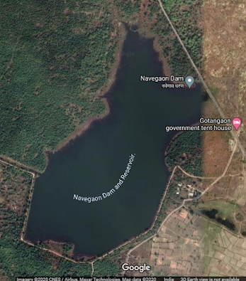
For viewing the surrounding areas and map page click HERE.38. Navegaon. ( Latitude : 20.9068872N, Longitude : 79.5331299E.)
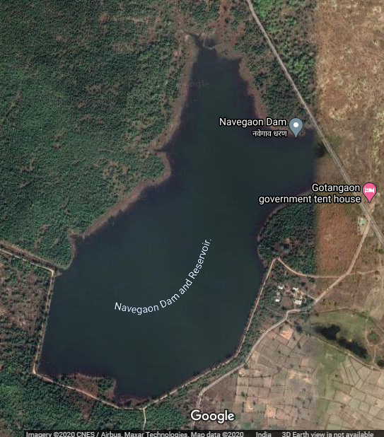
Map & link uploaded Aug- Sept 2020.
Some information about Navegaon Irrigation Project.
Official Designation of Navegaon Dam Irrigation Project is "Navegaon Dam , D - 04442 " . However local and popular name is " Navegaon Lake / Navegaon Talav ". Nawegaon dam Irrigation Project is constructed as part of irrigation projects in 1971 by the Government Maharashtra. It is built on a Local Nallah near city of Umrer in Nagpur District of Maharashtra . The dam is an Earth fill dam .The length of dam is 742 m ( 2434.38 ft ) , while the height of the dam above lowest foundation is 10.3 m ( 33.7926 feet ) . Project has a no proper Spillway of any type.Length of the spillway is Not known, spillway is un-gated.Its has catchment area is not known. Maximum / Gross storage capacity is 1.04 MCM. Live storage capacity is 0.98 MCM. Now a days almost all the water bodies make for good picnic spots.
Official Designation of Navegaon Dam Irrigation Project is "Navegaon Dam , D - 04442 " . However local and popular name is " Navegaon Lake / Navegaon Talav ". Nawegaon dam Irrigation Project is constructed as part of irrigation projects in 1971 by the Government Maharashtra. It is built on a Local Nallah near city of Umrer in Nagpur District of Maharashtra . The dam is an Earth fill dam .The length of dam is 742 m ( 2434.38 ft ) , while the height of the dam above lowest foundation is 10.3 m ( 33.7926 feet ) . Project has a no proper Spillway of any type.Length of the spillway is Not known, spillway is un-gated.Its has catchment area is not known. Maximum / Gross storage capacity is 1.04 MCM. Live storage capacity is 0.98 MCM. Now a days almost all the water bodies make for good picnic spots.
( Note : Blue area in normal map corresponds to Maximum / Full Reservoir Level.)
39. Ukarwahi . ( Latitude : 20.9367512N, Longitude : 79.2500067E.)

Map & link uploaded Aug- Sept 2020.
Some information about Ukarwahi Irrigation Project.
Official Designation of Ukarwahi Dam Irrigation Project is "Ukarwahi Dam , D - 04956 " . However local and popular name is " Ukarwahi Lake / Ukarwahi Talav ".Ukarwahi Irrigation Project is constructed as part of irrigation project by the Government of Maharashtra. It was completed in 1984. It is built on a Local Nallah near city of Umrer in Nagpur District of Maharashtra . The dam is an Earth fill dam .The length of dam is 820 m ( 2690.29 ft ) , while the height of the dam above lowest foundation is 14.14 m ( 46.3910 feet ) . Project has a Spillway of Ogee type.Length of the spillway is not known, the spillway is un-gated.Its catchment area is not known .Maximum / Gross storage capacity is 1.983 MCM. Live storage capacity is not known. Now a days almost all the water bodies make for good picnic spots and so does this place.
( Note : Blue area in normal map corresponds to Maximum / Full Reservoir Level.)
40. Paradgaon. ( Latitude : 20.9367512N, Longitude : 79.2500067E.)

Map & link uploaded Aug- Sept 2020.
Some information about Paradgaon Irrigation Project.
Official Designation of Paradgaon Irrigation Project is "Paradgaon D-04524" . Paradgaon Irrigation Project is locally and Popularly known as " Paradgaon Lake / Paradgaon Talav". Paradgaon Dam was constructed as part of irrigation projects by Government of Maharashtra in 1977 . It is built on Local nallah , nearest city to dam is Umred , in Nagpur District of Maharashtra . The dam is an Earth fill Dam .The length of dam is 500 m ( 1640.42 ft ) , while the height of the dam above lowest foundation is 14.28 m ( 46.8503 feet ) . Project hasa Spillway of other type.Length of the spillway is not known.The spillway is un-gated. The catchment area of project is not known. Maximum / Gross storage capacity is 105.13 MCM. Live storage capacity is 103 MCM. Now a days almost all the water bodies make for good picnic spots. Paradgaon Lake is also a popular Tourist attraction .Bar headed geese migrate here in ample numbers. One bar headed geese banded in Mangolia was found here in January 2008 .
Official Designation of Paradgaon Irrigation Project is "Paradgaon D-04524" . Paradgaon Irrigation Project is locally and Popularly known as " Paradgaon Lake / Paradgaon Talav". Paradgaon Dam was constructed as part of irrigation projects by Government of Maharashtra in 1977 . It is built on Local nallah , nearest city to dam is Umred , in Nagpur District of Maharashtra . The dam is an Earth fill Dam .The length of dam is 500 m ( 1640.42 ft ) , while the height of the dam above lowest foundation is 14.28 m ( 46.8503 feet ) . Project hasa Spillway of other type.Length of the spillway is not known.The spillway is un-gated. The catchment area of project is not known. Maximum / Gross storage capacity is 105.13 MCM. Live storage capacity is 103 MCM. Now a days almost all the water bodies make for good picnic spots. Paradgaon Lake is also a popular Tourist attraction .Bar headed geese migrate here in ample numbers. One bar headed geese banded in Mangolia was found here in January 2008 .
( Note : Blue area in normal map corresponds to Maximum / Full Reservoir Level.)
41. Saiki Nalla . ( Latitude : 20.914905N, Longitude : 79.1845608E.)

For viewing the surrounding areas and map page click HERE.
41. Saiki Nalla . ( Latitude : 20.914905N, Longitude : 79.1845608E.)

Map & link uploaded Aug- Sept 2020.
Some information about Saiki Nalla Irrigation Project.
Saiki Nalla Irrigation Project is locally and Popularly known as " Saiki Lake / Saiki Talav". Dam's Official Designation is "Saiki Nalla D-04524" . Saiki Nalla Dam was constructed as part of irrigation projects by Government of Maharashtra 1994 . It is built on Local nallah,.nearest city to dam is Umred in Nagpur District of Maharashtra . The dam is an Earth fill Dam .The length of dam is 1890 m ( 6200.787 ft ) , while the height of the dam above lowest foundation is 14.65 m ( 48.0643 feet ) . Project has no proper spillway as such.Length of the spillway is not known.The spillway is un-gated. It has a catchment area of 4.46 thousand hectors. Maximum / Gross storage capacity is 8.99 MCM. Live storage capacity is 6.98 MCM. Now a days almost all the water bodies make for good picnic spots. Saiki Lake is also a popular Tourist attraction for its scenic beauty .
Saiki Nalla Irrigation Project is locally and Popularly known as " Saiki Lake / Saiki Talav". Dam's Official Designation is "Saiki Nalla D-04524" . Saiki Nalla Dam was constructed as part of irrigation projects by Government of Maharashtra 1994 . It is built on Local nallah,.nearest city to dam is Umred in Nagpur District of Maharashtra . The dam is an Earth fill Dam .The length of dam is 1890 m ( 6200.787 ft ) , while the height of the dam above lowest foundation is 14.65 m ( 48.0643 feet ) . Project has no proper spillway as such.Length of the spillway is not known.The spillway is un-gated. It has a catchment area of 4.46 thousand hectors. Maximum / Gross storage capacity is 8.99 MCM. Live storage capacity is 6.98 MCM. Now a days almost all the water bodies make for good picnic spots. Saiki Lake is also a popular Tourist attraction for its scenic beauty .
( Note : Blue area in normal map corresponds to Maximum / Full Reservoir Level.)
42. Gothangaon. ( Latitude :20.8946894N, Longitude : 79.5250726E.)

42. Gothangaon. ( Latitude :20.8946894N, Longitude : 79.5250726E.)
Map & link uploaded Aug- Sept 2020.
For viewing the surrounding areas and map page click HERE.
Some information about Gothangaon Irrigation Project.
Official Designation of Gothangaon Irrigation Project is "Gothangaon D-03900" . Gothangaon Irrigation Project is locally and Popularly known as " Gothangaon Lake / Gothangaon Talav".Gothangaon Irrigation Project is constructed as part of irrigation projects in 1976 by the Government Maharashtra. It is built on a Local Nallah near city of Kuhi in Nagpur District of Maharashtra . The dam is an Earth fill dam .The length of dam is 1303 m ( 4274.934 ft ) , while the height of the dam above lowest foundation is 12.99 m ( 42.618 feet ) .Other details about spillway , Maximum storage and Live Storage capacity etc are not available.
Official Designation of Gothangaon Irrigation Project is "Gothangaon D-03900" . Gothangaon Irrigation Project is locally and Popularly known as " Gothangaon Lake / Gothangaon Talav".Gothangaon Irrigation Project is constructed as part of irrigation projects in 1976 by the Government Maharashtra. It is built on a Local Nallah near city of Kuhi in Nagpur District of Maharashtra . The dam is an Earth fill dam .The length of dam is 1303 m ( 4274.934 ft ) , while the height of the dam above lowest foundation is 12.99 m ( 42.618 feet ) .Other details about spillway , Maximum storage and Live Storage capacity etc are not available.
( Note : Blue area in normal map corresponds to Maximum / Full Reservoir Level.)
43. Pandharabodi. ( Latitude :20.821005 N, Longitude : 79.279553 E.)

For viewing the surrounding areas and map page click HERE.
43. Pandharabodi. ( Latitude :20.821005 N, Longitude : 79.279553 E.)

Some information about Pandherbodi Irrigation Project.
Official Designation of Pandherbodi Irrigation Project is "Pandherbodi D-01217" .Pandherbodi Irrigation Project is locally and Popularly known as " Pandherbodi Lake / Pandherbodi Talav". Pandherbodi Dam was constructed as part of irrigation projects by Government of Maharashtra in the year 1967 . It is built on .Pandherbodi River nearest city to dam is Umred in Nagpur District of Maharashtra . The dam is an Earth fill Dam .The length of dam is 1769 m ( 5803.806 ft ) , while the height of the dam above lowest foundation is 15.25 m ( 50.0 feet ) . Project has a Spillway of other type.Length of the spillway is not known .The spillway is un-gated. It has catchment area of 4.403 thousand hectors. Maximum / Gross storage capacity is 13.86 MCM. Live storage capacity is 13.12 MCM. Now a days almost all the water bodies make for good picnic spots. Pandherbodi Lake is also a popular Tourist attraction .for its scenic beauty .
Official Designation of Pandherbodi Irrigation Project is "Pandherbodi D-01217" .Pandherbodi Irrigation Project is locally and Popularly known as " Pandherbodi Lake / Pandherbodi Talav". Pandherbodi Dam was constructed as part of irrigation projects by Government of Maharashtra in the year 1967 . It is built on .Pandherbodi River nearest city to dam is Umred in Nagpur District of Maharashtra . The dam is an Earth fill Dam .The length of dam is 1769 m ( 5803.806 ft ) , while the height of the dam above lowest foundation is 15.25 m ( 50.0 feet ) . Project has a Spillway of other type.Length of the spillway is not known .The spillway is un-gated. It has catchment area of 4.403 thousand hectors. Maximum / Gross storage capacity is 13.86 MCM. Live storage capacity is 13.12 MCM. Now a days almost all the water bodies make for good picnic spots. Pandherbodi Lake is also a popular Tourist attraction .for its scenic beauty .
( Note : Blue area in normal map corresponds to Maximum / Full Reservoir Level.)
44. Makardhokada. ( Latitude : 20.870941 N, Longitude: 79.202891 E.)

For viewing the surrounding areas and map page click HERE.
( Note : Blue area in normal map corresponds to Maximum / Full Reservoir Level.)
44. Makardhokada. ( Latitude : 20.870941 N, Longitude: 79.202891 E.)
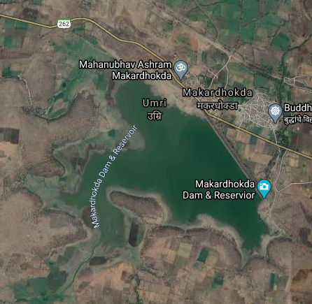
Map & link uploaded Aug- Sept 2020.
Some information about Makardhokada Irrigation Project.
Official Designation of Makardhokada Dam Irrigation Project is " Makardhokada Dam , D - 01402 " . However local and popular name is " Makardhokada Lake / Makardhokada Talav ". Makardhokada Dam was constructed as part of irrigation projects by Government of Maharashtra in the year 1978. It is built on and impounds Amb River , Nearest city to dam is Umrer in Nagpur District of Maharashtra . The dam is an Earth fill Dam .The Length of dam is 1645 m ( 5396.98 ft ) , while the Height of the dam above lowest foundation is 18.81 m (61.71 feet ) . Project has other type spillway as such.Length of the spillway is not known. The Dam has ungated Spillway. Dam's catchment area is 6.578 Thousand Hectors . Maximum / Gross storage capacity is 21.356 MCM. Live storage capacity is 19.931 MCM. Now a days almost all the water bodies make for good picnic spots. Makardhokada Lake is also a popular Tourist attraction for its scenic beauty .( Note : Blue area in normal map corresponds to Maximum / Full Reservoir Level.)
No comments:
Post a Comment