DAMS IN NAGPUR DISTRICT - PART THREE.(EDITED}
All 33 blogs covering 380 dams in 11 Districts of Vidarbha Region were edited between Aug & Sept 2020. For details go to blog "Vidarbha Region. Edit-Now - Why". Link here.
There are total of 54 Major Dams ( Height from foundation 10 meters or more ) in Nagpur District. Kochi Barrage,(excluded in edit as only dms covered) Information on these dams is covered in FIVE parts.
Information on dams which are covered in each Part is given below.
Part One.1. Nagalwadi. 2. Khekranala. 3. Mahurkund. 4. Raibasa. 5. Nanda. 6. Umri. 7 Kolar. 8. Kesar Nala. 9. Suwardhara. 10. Kamthikhairy / Pench Dam.
Part Two. 11. Sarekha. 12. Bhagimahari. 13. Zilpa. 14. Ramtek. 15. Adegaon. 16. Ranwadi. 17. Chandrabhaga 18. Paradsinga. 19. Junewani. 20. Khumari.
Part Three. 21. Surabardi. 22. Vena / Wena. 23. Jam. 24. Mordham. 25. Kotwalbordi. 26. Nandora. 27. Dhotewada. 28. Nandera. 29. Zilpi. 30. Ambazari. 31. Salaimenda. 32. Vyphadpitesur
Part Four. 33. Nanhi. 34. Khadki. 35. Kanholibara. 36. Anjangaon. 37. Walkeshwar38. Navegaon. 39. Ukarwahi. 40. Paradgaon. 41. Saiki Nalla . 42. Gothangaon. 43. Pandharabodi. 44. Makardhokada.
Part Five. 45. Lower wunna / Wadgaon. 46. Lower Wunna/ Nand.47. Nishanghat. 48. Botezari. 49. Khandezari. Nand.47. Nishanghat. 48. Botezari. 50. Urkundapar.51. Wani. 52. Totladoh. 53 Chorbahuli.
54 Pendhari.
21. Surabardi . ( Latitude : 21.1588398N , Longitude : 78.9383554E . )

Map & link uploaded Aug- Sept 2020.
For viewing the surrounding areas and map page click HERE
Some information about Surebardi Irrigation Project. Surebardi Irrigation Project is Popularly known as " Surebardi Lake / Surebardi Talav". Surabardi Dam's Official Designation is "Surebardi D-04882" . Surebardi Dam was constructed as part of irrigation projects by Government of Maharashtra in the year 1991 . It is built on Local nallah. Nearest city to dam is Nagpur in Nagpur District of Maharashtra . The dam is an Earth fill Dam .The length of dam is 945 m ( 3100.39 ft ) , while the height of the dam above lowest foundation is 11.74 m ( 38.517 feet ) . Project has no proper spillway as such.Length of the spillway is not known. Its catchment area is not known. Maximum / Gross storage capacity is 2.365 MCM. Live storage capacity is 1.37 MCM. Now a days almost all the water bodies make for good picnic spots. Surabardi Lake is also a popular Tourist attraction for its scenic beauty .
( Note : Blue area in normal map corresponds to Maximum / Full Reservoir Level.)
22. Vena / Wena / Wunna / Wana , ( Latitude : 21.1500747N , Longitude : 78.868103E . )

Vena / Wana Irrigation Project is Popularly known as " Vena Lake / V ena Talav". Vena Dam's Official Designation is "Wana D 06037" . Vena Dam ( has also been spelt as Wena , Wana , Wunna ) Reservoir is situated on NH 6 between Nagpur and Amravati. Vena Dam is located near Wadgaon Village in Umred Taluka of Nagpur District . It is built on Vena / Wunna River. Wana Dam, is an earthfil dam on Wana river near Nagpur . Wunna Dam, is an earthfil dam The height of the dam above its lowest foundation is 18.18 m (59.6 ft) while the length is 2,525 m (8,284 ft). Information about spillway not available. gross storage capacity is 23,5 MCM
22. Vena / Wena / Wunna / Wana , ( Latitude : 21.1500747N , Longitude : 78.868103E . )

Map & link uploaded Aug- Sept 2020.
For viewing the surrounding areas and map page click HERE
Some information about Vena Irrigation Project. Vena / Wana Irrigation Project is Popularly known as " Vena Lake / V ena Talav". Vena Dam's Official Designation is "Wana D 06037" . Vena Dam ( has also been spelt as Wena , Wana , Wunna ) Reservoir is situated on NH 6 between Nagpur and Amravati. Vena Dam is located near Wadgaon Village in Umred Taluka of Nagpur District . It is built on Vena / Wunna River. Wana Dam, is an earthfil dam on Wana river near Nagpur . Wunna Dam, is an earthfil dam The height of the dam above its lowest foundation is 18.18 m (59.6 ft) while the length is 2,525 m (8,284 ft). Information about spillway not available. gross storage capacity is 23,5 MCM
( Note : Blue area in normal map corresponds to Maximum / Full Reservoir Level.)

23. Jam . ( Latitude : 21.2204011N , Longitude : 78.6424327E . )

Map & link uploaded Aug- Sept 2020.
For viewing the surrounding areas and map page click HERE.
Some information about Jam Irrigation Project.
Jam Irrigation Project, Locally and Popularly known as " Jam Lake / Jam Talav ". The Dam's Official Designation is "Jam D-03081" .Jam Dam was constructed as part of irrigation projects by Government of Maharashtra in the year1996 . It is built on Jam River near Katol in Nagpur District of Maharashtra . The dam is an Earth fill Dam .The length of dam is 3460 m ( 11351.71 feet ) while The height of the dam above lowest foundation is 24 m (79 ft). Project has a Spillway of Ogee type.Length of the spillway is 258 m ( 846.457 ft ) The spillway is un-gated. It has catchment area of 17.1 thousand hectors. Maximum / Gross storage capacity is 28.05 MCM. Live storage capacity is 23.55 MCM. Now a days almost all the water bodies make for good picnic spots. Jam Lake is also a popular Tourist attraction for its scenic beauty . Lots of water sports and boating adds to the tourist enjoyment.( Note : Blue area in normal map corresponds to Maximum / Full Reservoir Level.)
24. Mordham. ( Latitude : 21.2210612N , Longitude :78.8054466E . )

For viewing the surrounding areas and map page click HERE.
24. Mordham. ( Latitude : 21.2210612N , Longitude :78.8054466E . )

Map & link uploaded Aug- Sept 2020.
Some information about Mordham Irrigation Project.
Official Designation of Mordham Dam Irrigation Project is " Mordham Dam , D - 01385 " . However local and popular name is " Phutana Lake / Phitana Talav ". Mordham Dam was constructed as part of irrigation projects by Government of Maharashtra in the year 1979 It is built on Mordham River .Nearest city to dam is .Kalmeshwar in Nagpur District of Maharashtra . The dam is an Earth fill Dam .The Length of dam is 1940 m ( 6364.829 ft ) , while the Height of the dam above lowest foundation is 15.19 m ( 49.8359 feet ) . Project has a Spillway of Ogee type . Length of the spillway is not known. The spillway is un-gated.Dam has catchment area of 3.3152 thousand hectors. Maximum / Gross storage capacity is 5.444 MCM. Live storage capacity is 4.953 MCM. Now a days almost all the water bodies make for good picnic spots. Mordham/Phutana Lake is also a popular Tourist attraction for its scenic beauty .( Note : Blue area in normal map corresponds to Maximum / Full Reservoir Level.)
25. Kotwalbordi . ( Latitude : 21.2132899N , Longitude : 78.7609863E . )

For viewing the surrounding areas and map page click HERE.
Some information about Kotwalbordi Irrigation Project.
Official Designation of Kotwalbordi Dam Irrigation Project is " Kotwalbordi Dam , D - 04212 " . However local and popular name is " Kotwalbordi Lake / Kotwalbordi Talav ". Kotwalbordi Dam was constructed as part of irrigation projects by Government of Maharashtra in the year 1974 It is built on Local nallah. Nearest city to dam is Katol in Nagpur District of Maharashtra . The dam is an Earth fill Dam .The Length of dam is 510 m ( 1673.23 ft ) , while the Height of the dam above lowest foundation is 15.23 m ( 49.9671 feet ) . Project has no proper spillway as such . Length of the spillway is not known.Dam's catchment area is not known . Maximum / Gross storage capacity is 1.418 MCM. Live storage capacity is 1.32 MCM. Now a days almost all the water bodies make for good picnic spots. Kotwalbordi Lake is also a popular Tourist attraction for its scenic beauty .
25. Kotwalbordi . ( Latitude : 21.2132899N , Longitude : 78.7609863E . )

Map & link uploaded Aug- Sept 2020.
For viewing the surrounding areas and map page click HERE.
Official Designation of Kotwalbordi Dam Irrigation Project is " Kotwalbordi Dam , D - 04212 " . However local and popular name is " Kotwalbordi Lake / Kotwalbordi Talav ". Kotwalbordi Dam was constructed as part of irrigation projects by Government of Maharashtra in the year 1974 It is built on Local nallah. Nearest city to dam is Katol in Nagpur District of Maharashtra . The dam is an Earth fill Dam .The Length of dam is 510 m ( 1673.23 ft ) , while the Height of the dam above lowest foundation is 15.23 m ( 49.9671 feet ) . Project has no proper spillway as such . Length of the spillway is not known.Dam's catchment area is not known . Maximum / Gross storage capacity is 1.418 MCM. Live storage capacity is 1.32 MCM. Now a days almost all the water bodies make for good picnic spots. Kotwalbordi Lake is also a popular Tourist attraction for its scenic beauty .
( Note : Blue area in normal map corresponds to Maximum / Full Reservoir Level.)
26. Nandora. ( Latitude : 21.1736173N , Longitude : 78.6053109E. )


Dhotewada Irrigation Project, locally Popularly known as " Dhotewada Lake / DhotewadaTalav". Dam's Official Designation is "Dhotewada D-03689" . Dhotewada Dam was constructed as part of irrigation projects by Government of Maharashtra in the year 1977 . It is built on Local nallah nearest city to dam is Katol in Wardha District of Maharashtra . The dam is an Earth fill Dam .The length of dam is 580 m ( 1902.89 ft ) , while the height of the dam above lowest foundation is 14.88 m ( 48.8188 feet ) . Project has no proper spillway as such . Length of the spillway is not known....... The spillway is un-gated . Dam's catchment area is not known . Maximum / Gross storage capacity is 1.724 MCM. Live storage capacity is 1.417 MCM. Now a days almost all the water bodies make for good picnic spots. Dhotewada Lake is also a popular Tourist attraction for its scenic beauty .
26. Nandora. ( Latitude : 21.1736173N , Longitude : 78.6053109E. )

Map & link uploaded Aug- Sept 2020.
For viewing the surrounding areas and map page click HERE.
Some information about Nandora Irrigation Project.
Nandora Irrigation Project, Locally and Popularly known as " Nandora Lake / Nandora ". There is one more project with similar name , "Nandera - D-4419", near Nandera city, Nagpur Dist. Nandora Dam's Official Designation is "Nandora ,D 04425." .Nandora Dam was constructed as part of irrigation projects by Government of Maharashtra in the year 1988 . It is built on Local nallah . Nearest city to dam is Hingna in Nagpur District of Maharashtra . The dam is an Earth fill Dam .The length of dam is 534 m ( 1751.97 ft ) , while the height of the dam above lowest foundation is 118.8 m ( 61.679 feet ) . Project has no proper spillway as such.Length of the spillway is not known.The spillway is un-gated.Dam's catchment area is not known.Maximum / Gross storage capacity is 2.57 MCM. Live storage capacity is 2.18 MCM. Now a days almost all the water bodies make for good picnic spots. Nandora. Lake is also a popular attraction for its scenic beauty .
( Note : Blue area in normal map corresponds to Maximum / Full Reservoir Level.)
27. Dhotewada. ( Latitude : 21.0462148N , Longitude : 78.6470354E. )
Map & link uploaded Aug- Sept 2020.
For viewing the surrounding areas and map page click HERE.
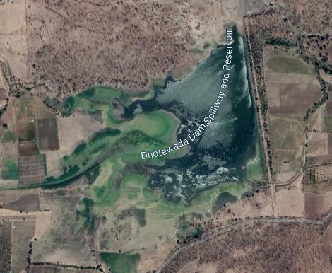
Some information about Dhotewada Irrigation Project.Dhotewada Irrigation Project, locally Popularly known as " Dhotewada Lake / DhotewadaTalav". Dam's Official Designation is "Dhotewada D-03689" . Dhotewada Dam was constructed as part of irrigation projects by Government of Maharashtra in the year 1977 . It is built on Local nallah nearest city to dam is Katol in Wardha District of Maharashtra . The dam is an Earth fill Dam .The length of dam is 580 m ( 1902.89 ft ) , while the height of the dam above lowest foundation is 14.88 m ( 48.8188 feet ) . Project has no proper spillway as such . Length of the spillway is not known....... The spillway is un-gated . Dam's catchment area is not known . Maximum / Gross storage capacity is 1.724 MCM. Live storage capacity is 1.417 MCM. Now a days almost all the water bodies make for good picnic spots. Dhotewada Lake is also a popular Tourist attraction for its scenic beauty .
( Note : Blue area in normal map corresponds to Maximum / Full Reservoir Level.)
28. Nandera. ( Latitude : 21.0913471N , Longitude : 78.8556361E. )
28. Nandera. ( Latitude : 21.0913471N , Longitude : 78.8556361E. )

Map & link uploaded Aug- Sept 2020.
For viewing the surrounding areas and map page click HERE.
Some information about Nandera Irrigation Project.Official Designation of Nandera Dam Irrigation Project is " Nandera Dam , D - 04419 " . However local and popular name is " Nandera/Nandora Lake / Nandera/Nandora Talav ". Nandera Dam was constructed as part of irrigation projects by Government of Maharashtra in the year 1971 It is built on Local nallah . Nearest city to dam is Nagpur in Nagpur District of Maharashtra . The dam is an Earth fill Dam .The Length of dam is 594 m ( 1948.82 ft ) , while the Height of the dam above lowest foundation is 10.8 m ( 35.433 feet ) . Project has no proper spillway as such.Length of the spillway is not known.Dam's catchment area is not known Maximum / Gross storage capacity is 3.25 MCM. Live storage capacity is 3.02 MCM. Now a days almost all the water bodies make for good picnic spots. Nandera Lake is also a popular Tourist attraction for its scenic beauty . Lots of water sports and boating adds to the tourist enjoyment.
( Note : Blue area in normal map corresponds to Maximum / Full Reservoir Level.)
29. Zilpi. ( Latitude : 21.063917N , Longitude :78.868264E. )

30. Ambazari. ( Latitude : 21.040317N , Longitude :78.8280416E. )

Official Designation of Ambazari Dam Irrigation Project is " Ambazari Dam , D - 03273 " .
29. Zilpi. ( Latitude : 21.063917N , Longitude :78.868264E. )

Map & link uploaded Aug- Sept 2020.
For viewing the surrounding areas and google map go HERE.
Some information about Zilpi Irrigation project.
Information about Zilpi Dam Irrigation Project.Official Designation of Zilpi Dam Irrigation Project is " Zilpi Dam , D - 04419 " . However local and popular name is " Zilpi Lake / Zilpi Talav ". Zilpi Dam was constructed as part of irrigation projects by Government of Maharashtra in the year 1974 It is built on Local nallah . Nearest city to dam is Hingna in Nagpur District of Maharashtra . The dam is an Earth fill Dam .The Length of dam is 409 m ( 11341.86 ft ) , while the Height of the dam above lowest foundation is 18.85 m ( 62.1719 feet ) . Project has no proper spillway as such.Length of the spillway is not known.Dam's catchment area is not known Maximum / Gross storage capacity is 1.559 MCM. Live storage capacity is 1.51 MCM. Now a days almost all the water bodies make for good picnic spots. Zilpe Lake is also a popular Tourist attraction for its scenic beauty . "Maitriban".an old age home is established on Western shore.
( Note : Blue area in normal map corresponds to Maximum / Full Reservoir Level.)

Map & link uploaded Aug- Sept 2020.
For viewing the surrounding areas and map page click HERE.
Some information about Ambazari Irrigation Project.Official Designation of Ambazari Dam Irrigation Project is " Ambazari Dam , D - 03273 " .
This Ambazari Lake and irrigation project is not to be confused with another lake of the same name which is located within the city limits of Nagpur City and popularly known as " Ambazari Lake / Ambazari Talav ". Nearest city to dam is Hingana in Nagpur District of Maharashtra . The dam is an Earth fill Dam .The Length of dam is 952.51 m ( 3125.0328 ft ) , while the Height of the dam above lowest foundation is 13.71 m ( 56.7913 feet ) . Project has no proper spillway as such.Length of the spillway is not known.Dam's catchment area is not known Maximum / Gross storage capacity is 8.37 MCM. Live storage capacity is nit known.Now a days almost all the water bodies make for good picnic spots. Ambazari Lake is also a popular Tourist attraction for its scenic beauty .
( Note : Blue area in normal map corresponds to Maximum / Full Reservoir Level.)
31. Salaimenda. ( Latitude : 21.0370826N , Longitude : 78.8801837E. )

Official Designation of Salaimendha Dam Irrigation Project is " Salaimendha Dam , D - 04740 " . However local and popular name is " Salaimendha Lake / Salaimendha Talav ". Salaimendha Dam was constructed as part of irrigation projects by Government of Maharashtra in the year 1972. It is built on and impounds a Local nallah . Nearest city to dam is Hingna in Nagpur District of Maharashtra . The dam is an Earth fill Dam .The Length of dam is 247 m ( 810.367 ft ) , while the Height of the dam above lowest foundation is 20.57 m ( 67.4868 feet ) . Project has no proper spillway as such.Length of the spillway is not known.Dam's catchment area is not known Maximum / Gross storage capacity is 2.23 MCM. Live storage capacity is 2.11 MCM. Now a days almost all the water bodies make for good picnic spots. Salaimendha Lake is also a popular Tourist attraction for its scenic beauty.
31. Salaimenda. ( Latitude : 21.0370826N , Longitude : 78.8801837E. )

Map & link uploaded Aug- Sept 2020.
For viewing the surrounding areas and map page click HERE.
Some information about Salaimandha Irrigation Project.Official Designation of Salaimendha Dam Irrigation Project is " Salaimendha Dam , D - 04740 " . However local and popular name is " Salaimendha Lake / Salaimendha Talav ". Salaimendha Dam was constructed as part of irrigation projects by Government of Maharashtra in the year 1972. It is built on and impounds a Local nallah . Nearest city to dam is Hingna in Nagpur District of Maharashtra . The dam is an Earth fill Dam .The Length of dam is 247 m ( 810.367 ft ) , while the Height of the dam above lowest foundation is 20.57 m ( 67.4868 feet ) . Project has no proper spillway as such.Length of the spillway is not known.Dam's catchment area is not known Maximum / Gross storage capacity is 2.23 MCM. Live storage capacity is 2.11 MCM. Now a days almost all the water bodies make for good picnic spots. Salaimendha Lake is also a popular Tourist attraction for its scenic beauty.
( Note : Blue area in normal map corresponds to Maximum / Full Reservoir Level.)
32. Vyphadpitesur. ( Latitude : 20.9930156N , Longitude : 78.9206314E. )

Some information about Vyphadpitesur Irrigation Project.
Official Designation of Vyphadpitesur Dam Irrigation Project is " Vyphadpitesur Dam , D - 05012 " . However local and popular name is " Vyphadpitesur Lake / Vyphadpitesur Talav ". It is also spelt as Viphadpitesur .Vyphadpitesur Dam was constructed as part of irrigation projects by Government of Maharashtra year of completion is not known. It is built on and impounds a Local nallah . Nearest city to dam is Hingna in Nagpur District of Maharashtra . The dam is an Earth fill Dam .The Length of dam is 508 m ( 810.367 ft ) , while the Height of the dam above lowest foundation is 10.2 m ( 67.4868 feet ) . Project has no proper spillway as such.Length of the spillway is not known.Dam's catchment area is not known Maximum / Gross storage capacity is 1.08 MCM. Live storage capacity is 0.81 MCM. Now a days almost all the water bodies make for good picnic spots. Vyphadpitesur Lake is also a popular Tourist attraction for its scenic beauty
( Note : Blue area in normal map corresponds to Maximum / Full Reservoir Level.)
32. Vyphadpitesur. ( Latitude : 20.9930156N , Longitude : 78.9206314E. )

Map & link uploaded Aug- Sept 2020.
For viewing the surrounding areas and map page click HERE.
Official Designation of Vyphadpitesur Dam Irrigation Project is " Vyphadpitesur Dam , D - 05012 " . However local and popular name is " Vyphadpitesur Lake / Vyphadpitesur Talav ". It is also spelt as Viphadpitesur .Vyphadpitesur Dam was constructed as part of irrigation projects by Government of Maharashtra year of completion is not known. It is built on and impounds a Local nallah . Nearest city to dam is Hingna in Nagpur District of Maharashtra . The dam is an Earth fill Dam .The Length of dam is 508 m ( 810.367 ft ) , while the Height of the dam above lowest foundation is 10.2 m ( 67.4868 feet ) . Project has no proper spillway as such.Length of the spillway is not known.Dam's catchment area is not known Maximum / Gross storage capacity is 1.08 MCM. Live storage capacity is 0.81 MCM. Now a days almost all the water bodies make for good picnic spots. Vyphadpitesur Lake is also a popular Tourist attraction for its scenic beauty
( Note : Blue area in normal map corresponds to Maximum / Full Reservoir Level.)
No comments:
Post a Comment