DAMS IN BULDHANA DISTRICT - PART ONE (EDITED).
All 33 blogs covering 380 dams in 11 Districts of Vidarbha Region were edited between Aug & Sept 2020. For details go to blog "Vidarbha Region. Edit-Now - Why". Link here.
There are total of 60 Major Dams ( Height from foundation 10 meters or more ) in Buldhana District.
Information on these dams is covered in Five PartsPart One. 1.Gandhari. 2.Shivanijat. 3.Titwi. 4.Pimpal ner.ner. 5. Ambhora. 6.Vidrupa. 7. Garkhed. 8. Pimparkhed. 9.Tambola. 10.Chorpangra. 11. Mandwa. 12. Saokhed
Bhoi.
Part Two.13. Keshavshivani. 14. Khadakpurna. 15. Shivani Armal. 16. Ancharwadi
-1. 17. Ancharwadi - II 18. Misalwadi
19. Kalapvihir. 20. Jagdari. 21. Sawangimali -1. 22. Sawangimali 2. 23. Koradi .24. Khandala. 25. Pentakali. 26. Kalmeshwar.
Part Three. 27. Patoda. 28. Telhara.
29. Haralkhed. 30. Kawala .
31. Utawali. 32.Mun.
33. Torna. 34. Fattepur. 35. Ganeshpur.
36. Hiwarkhed. 37. Mas .
38. Matla. 39. Pangrikesapur.
Part
Four. 40. Kardi.
41. Gyanganga. 42. Shekapur. 43. Zari. 44. Dahid / Dahad.
45. Paldhag. 46. Botha / Pimpri.
47. Garadgaon. 48. Pimpalgaon Nath. 49. Dhamangaon
Deshmukh / Kothali. 50 . Takli.
Part
Five. 51. Kandari. 52 . Borjawala. 53 . Wari. 54 . Nalganga. 55
. Kolhigolar. 56 . Khandwa. 57. Dhanora. 58 . Rajura. 59
. Godada / Gorada.60.Jigaon.
1. Gandhari. ( LATUTUDE : 19.8746609N, LONGITUDE : 76.615026E )

For viewing the surrounding areas and the map page click
There are two dams with the same name in Maharashtra .This is one, the other one is near Sakoli town in Bhandara District.
Gandhari Reservoir was created as a result of construction of Gandhari Dam of Gandhari Irrigation Project . Official Designation of the The Project and Dam is " Gandhari D - 0 3814" . Gandhari Reservoir is locally also known as " Gandhari Lake" / " Gandhari Talav" . Gandhari Peoject was constructed as part of irrigation Schemes by Government of Maharashtra in the year 1976. Nearest city to dam is Lonar and the Dam is situated in Lonar Taluka of Buldana District of Maharashtra . Gandhari Peoject dam is built on and impounds a Local Nallah .The Project is an Earth-fill Gravity Dam . Purpose of the Project is for irrigation . The length of the dam is 390 m ( 1279.53 Feet ) while the height of the dam above lowest foundation is 18.03 m ( 59.15 Feet ) . Detailed information about project spillway is not available . Project Spillway length is not known . Whatever is left of what was once a Spillway , is in a bad condition being eroded and partly washed away
Catchment area of Gandhari Reservoir is not known . Maximum / Gross storage capacity oh Gandhari Reservoir is 2.412 MCM . Live storage capacity is 2.279 MCM . Now a days almost all the water bodies make for good picnic spots Ganfhari lake is also a popular Tourist attraction for its scenic beauty .

Map & link uploaded Aug- Sept 2020.
Some information about Gandhari Irrigation Project.
Gandhari Reservoir was created as a result of construction of Gandhari Dam of Gandhari Irrigation Project . Official Designation of the The Project and Dam is " Gandhari D - 0 3814" . Gandhari Reservoir is locally also known as " Gandhari Lake" / " Gandhari Talav" . Gandhari Peoject was constructed as part of irrigation Schemes by Government of Maharashtra in the year 1976. Nearest city to dam is Lonar and the Dam is situated in Lonar Taluka of Buldana District of Maharashtra . Gandhari Peoject dam is built on and impounds a Local Nallah .The Project is an Earth-fill Gravity Dam . Purpose of the Project is for irrigation . The length of the dam is 390 m ( 1279.53 Feet ) while the height of the dam above lowest foundation is 18.03 m ( 59.15 Feet ) . Detailed information about project spillway is not available . Project Spillway length is not known . Whatever is left of what was once a Spillway , is in a bad condition being eroded and partly washed away
Catchment area of Gandhari Reservoir is not known . Maximum / Gross storage capacity oh Gandhari Reservoir is 2.412 MCM . Live storage capacity is 2.279 MCM . Now a days almost all the water bodies make for good picnic spots Ganfhari lake is also a popular Tourist attraction for its scenic beauty .
( Note : Blue area in normal map corresponds to Maximum / Full Reservoir Level.)
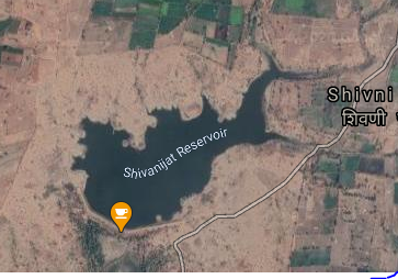
2. Shivanijat. ( LATUTUDE : 19.898688 LONGITUDE: 76.595561)
For viewing the surrounding areas and the map page click HERE.
3. Titwi. ( LATUTUDE : 19.9097594N, LONGITUDE : 76.5430892E )


5. Ambhora. ( LATUTUDE : 19.9410782N, LONGITUDE : 76.5127373E )

6. Vidrupa. ( LATUTUDE : 19.8853961N, LONGITUDE : 76.3130951E )

7. Garkhed. ( LATUTUDE : 19.8919337N, LONGITUDE : 76.2222862E)

8. Pimparkhed. ( LATUTUDE : 19.9313353N, LONGITUDE : 76.2355042E )
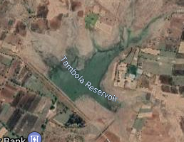
9. Tambola. ( LATUTUDE : 19.9916997N, LONGITUDE : 76.4542866E )


2. Shivanijat. ( LATUTUDE : 19.898688 LONGITUDE: 76.595561)

Map & link uploaded Aug- Sept 2020.
Some information about Shivanijat Irrigation Project.
Shivanijat Reservoir was created as a result of construction of Shivanijat Dam of Shivanijat Irrigation Project . Official Designation of the The Project is " Shivanijat D - 0 4837" . Shivanijat Reservoir is locally also known as " Shivanijat Lake" / " Shivanijat Talav" . Shivanijat Peoject was constructed as part of irrigation projects by Government of Maharashtra in the year 1973. Nearest city to dam is Lonar and the Dam is situated in Lonar Taluka of Buldana District of Maharashtra . Gandhari Project is built on and impounds a Local Nallah .The Project Dam is an Earth-fill Gravity Dam . Purpose of the Project is for irrigation . The length of the dam is 570 m ( 1870.08 Feet ) while the height of the dam above lowest foundation is 15.9 m ( 52.16 Feet ) . Detailed information about project spillway is not available . Project Spillway length is not known . Whatever is left of what was once a Spillway , is in a bad condition being eroded and partly washed away
Catchment area of Gandhari Reservoir is not known . Maximum / Gross storage capacity oh Gandhari Reservoir is 1.48 MCM . Live storage capacity is 1.38 MCM . Now a days almost all the water bodies make for good picnic spots Ganfhari lake is also a popular Tourist attraction for its scenic beauty .
Catchment area of Gandhari Reservoir is not known . Maximum / Gross storage capacity oh Gandhari Reservoir is 1.48 MCM . Live storage capacity is 1.38 MCM . Now a days almost all the water bodies make for good picnic spots Ganfhari lake is also a popular Tourist attraction for its scenic beauty .
( Note : Blue area in normal map corresponds to Maximum / Full Reservoir Level.)

Map & link uploaded Aug- Sept 2020.
For viewing the surrounding areas and the map page click HERE.
Some information about Titwi Irrigation Project.
Titwi Reservoir was created as a result of construction of Titwi Dam of Titwi Irrigation Project . Official Designation of the The Project is " Titwi D - 0 4945" . Titwi Reservoir is locally also known as " Titwi Lake" / " Titwiivanijat Talav" . Titwi Peoject was constructed as part of irrigation projects by Government of Maharashtra in the year 1972. Nearest city to dam is Lonar and the Dam is situated in Lonar Taluka of Buldana District of Maharashtra . Titwi Project is built on and impounds a Local Nallah .The Project Dam is an Earth-fill Gravity Dam . Purpose of the Project is for irrigation . The length of the dam is 205 m ( 672.57 Feet ) while the height of the dam above lowest foundation is 19.55 m ( 64.14 Feet ) . Detailed information about project spillway is not available . Project Spillway length is not known . However measured spillway length is 73 m ( 240 Feet ). Spillway is Ogee type and it is ungated. Catchment area of Titwi Reservoir is not known . Maximum / Gross storage capacity of Titwi Reservoir is 3.11 MCM . Live storage capacity is 2.879 MCM . Now a days almost all the water bodies make for good picnic spots Titwi lake is also a popular Tourist attraction for its scenic beauty .
( Note : Blue area in normal map corresponds to Maximum / Full Reservoir Level.)
( Note : Blue area in normal map corresponds to Maximum / Full Reservoir Level.)
4. Pimpal Ner. ( LATUTUDE : 119.945014N, LONGITUDE : 76.572460E )

Map & link uploaded Aug- Sept 2020.
For viewing the surrounding areas and the map page click HERE.
Some information about Pimpal Ner Irrigation Project.
Pimpal Ner Reservoir was created as a result of construction of Pimpal Ner Dam of Pimpal Ner Irrigation Project . Official Designation of the The Project is " Pimpal Ner D - 0 4602" . Pimpal Ner Reservoir is locally also known as " Pimpal Ner Lake" / " Pimpal Ner Talav" . Pimpal Ner Peoject was constructed as part of irrigation projects by Government of Maharashtra in the year 1979. Nearest city to dam is Lonar and the Dam is situated in Lonar Taluka of Buldana District of Maharashtra . Pimpal Ner Project is built on and impounds a Local Nallah .The Project Dam is an Earth-fill Gravity Dam . Purpose of the Project is for irrigation . The length of the dam is 424 m ( 1391.08 Feet ) while the height of the dam above lowest foundation is 16.3 m ( 53.47 Feet ) . Detailed information about project spillway is not available . Project Spillway length is not known . However , measured spillway length is 71 m ( 234 Feet ). Spillway is other type and it is ungated. Catchment area of Pimpal Ner Reservoir is not known . Maximum / Gross storage capacity of Pimpal Ner Reservoir is 2.09 MCM . Live storage capacity is 1.76 MCM . Now a days almost all the water bodies make for good picnic spots Titwi lake is also a popular Tourist attraction for its scenic beauty .
( Note : Blue area in normal map corresponds to Maximum / Full Reservoir Level.)
( Note : Blue area in normal map corresponds to Maximum / Full Reservoir Level.)

Map & link uploaded Aug- Sept 2020.
For viewing the surrounding areas and the map page click HERE.
Some information about Ambhora Irrigation Project.
Ambhora Reservoir was created as a result of construction of Ambhora Dam of Ambhora Irrigation Project . Official Designation of the The Project is " Ambhora D - 0 3278" . Ambhora Reservoir is locally also known as " Ambhora Lake" / " Ambhora Talav" . Ambhora Peoject was constructed as part of irrigation projects by Government of Maharashtra the year of completion is not known. Nearest city to dam is Lonar and the Dam is situated in Lonar Taluka of Buldana District of Maharashtra . Ambhora Project is built on and impounds a Local Nallah .The Project Dam is an Earth-fill Gravity Dam . Purpose of the Project is for irrigation . The length of the dam is 625 m ( 2050.52 Feet ) while the height of the dam above lowest foundation is 13.59 m ( 44.58 Feet ) . Detailed information about project spillway is not available . Project Spillway length is not known . However , measured spillway length is 60 m ( 197 Feet ). Spillway is other type and it is ungated. Catchment area of Ambhora Reservoir is not known . Maximum / Gross storage capacity of Pimpal Ner Reservoir is 1.24 MCM . Live storage capacity is 0.93 MCM . Now a days almost all the water bodies make for good picnic spots Titwi lake is also a popular Tourist attraction for its scenic beauty .
( Note : Blue area in normal map corresponds to Maximum / Full Reservoir Level.)
( Note : Blue area in normal map corresponds to Maximum / Full Reservoir Level.)

Map & link uploaded Aug- Sept 2020.
For viewing the surrounding areas and the map page click HERE.
Some information about Vidrupa Irrigation Project.
Vidrupa Reservoir was created as a result of construction of Vidrupa Dam of Vidrupa Irrigation Project . Official Designation of the The Project is " Vidrupa D - 0 4997" . Vidrupa Reservoir is locally also known as " Vidrupa Lake" / " Vidrupa Talav" . Vidrupa Peoject was constructed as part of irrigation projects by Government of Maharashtra the year of completion the year 1991. Nearest city to dam is Shindkhed Raja and the Dam is situated in Shindkhed Raja Taluka of Buldana District of Maharashtra . Vidrupa Project is built on and impounds Vidrupa River .The Project Dam is an Earth-fill Gravity Dam . Purpose of the Project is for irrigation . The dam is divided in two portions by the Spillway. The portion Left ( Northern Side ) of the spillway is 894 m ( 2934 Feet ) + The portion Right ( Southern Side ) of the spillway is 145 m ( 476 Feet ) . The Total length of the Dam , including the Spillway is 1183 m ( 3881 Feet ) . while the height of the dam above lowest foundation is 16.36 m ( 54 Feet ) . Detailed information about project spillway is not available . Project Spillway length is not known . However , measured spillway length is 144 m ( 417 Feet ). Spillway is other type and it is ungated. Catchment area of Vidrupa Reservoir is not known . Maximum / Gross storage capacity of Vidrupa Reservoir is not known. Live storage capacity is not known . Now a days almost all the water bodies make for good picnic spots Vidrupa lake is also a popular Tourist attraction for its scenic beauty .
( Note : Blue area in normal map corresponds to Maximum / Full Reservoir Level.)
( Note : Blue area in normal map corresponds to Maximum / Full Reservoir Level.)

Map & link uploaded Aug- Sept 2020.
For viewing the surrounding areas and the map page click HERE.
Some information about Garkhed Irrigation Project.
Garkhed Dam of Garkhed Irrigation Project . Official Designation of the The Project is " Garkhed D - 0 3826" . Garkhed Reservoir is locally also known as " Garkhed Lake" / " Garkhed Talav" . Garkhed Peoject was constructed as part of irrigation projects by Government of Maharashtra the year of completion the year 1970. Nearest city to dam is Shindkhed Raja and the Dam is situated in Shindkhed Raja Taluka of Buldana District of Maharashtra . Garkhed Project is built on and impounds a Local Nallah .The Project Dam is an Earth-fill Gravity Dam . Purpose of the Project is for irrigation . The length of the Dam is 472 m ( 1548.56 Feet ) . while the height of the dam above lowest foundation is 16.19 m ( 53.11 Feet ) . Detailed information about project spillway is not available . Spillway length is not known . However , measured spillway length is 64 m ( 209 Feet ). Spillway is of other type and it is ungated. Catchment area of Garkhed Reservoir is not known . Maximum / Gross storage capacity of Garkhed Reservoir is 2.163 MCM . Live storage capacity is 1.99 MCM . Now a days almost all the water bodies make for good picnic spots Garkhed lake is also a popular Tourist attraction for its scenic beauty .
( Note : Blue area in normal map corresponds to Maximum / Full Reservoir Level.)

Map & link uploaded Aug- Sept 2020.
For viewing the surrounding areas and the map page click HERE.
Title Pimparkhed Reservoir is wrongly printed almost 500 to 600 meters North East of the Dam location.
Some information about Garkhed Irrigation Project.
Pimparkhed Reservoir was created as a result of construction of Pimparkhed Dam of Pimparkhed Irrigation Project . Official Designation of the The Project is " Pimparkhed D - 0 4612" . Pimparkhed Reservoir is locally also known as " Pimparkhed Lake" / " Pimparkhed Talav" . Pimparkhed Peoject was constructed as part of irrigation projects by Government of Maharashtra the year of completion the year 1973. Nearest city to dam is Shindkhed Raja and the Dam is situated in Shindkhed Raja Taluka of Buldana District of Maharashtra . Pimparkhed Project is built on and impounds a Local Nallah .The Project Dam is an Earth-fill Gravity Dam . Purpose of the Project is for irrigation . The length of the Dam is 426 m ( 1397.64 Feet ) . while the height of the dam above lowest foundation is 17.11 m ( 56.13 Feet ) . Detailed information about project spillway is not available . Spillway length is not known . The condition of the spillway is not too good .At least whatever is left of what was once a Spillway , is in a very bad condition being eroded and partly washed away and only spillway canal exists
Catchment area of Pimparkhed Reservoir is not known . Maximum / Gross storage capacity of Pimparkhed Reservoir is 1.335 MCM . Live storage capacity is 12.82 MCM . Now a days almost all the water bodies make for good picnic spots Pimparkhed lake is also a popular Tourist attraction for its scenic beauty .
( Note : Blue area in normal map corresponds to Maximum / Full Reservoir Level.)
Map & link uploaded Aug- Sept 2020.
For viewing the surrounding areas and the map page click HERE
Some information about Tambola Irrigation Project.
Tambola Reservoir was created as a result of construction of Tambola Dam of Tambola Irrigation Project . Official Designation of the The Project is " Tambola D - 0 4905" . Tambola Reservoir is locally also known as " Tambola Lake" / " Tambola Talav" . Tambola Peoject was constructed as part of irrigation projects by Government of Maharashtra the year of completion the year 1979. Nearest city to dam is Lonar and the Dam is situated in Lonar Taluka of Buldana District of Maharashtra . Tambola Project is built on and impounds a Local Nallah .The Project Dam is an Earth-fill Gravity Dam . Purpose of the Project is for irrigation . The length of the Dam is 749 m ( 2457.35 Feet ) . while the height of the dam above lowest foundation is 15.76 m ( 51.70 Feet ) . Detailed information about project spillway is not available . Spillway length is not known . However , measured spillway length is 77 m ( 254 Feet ). Spillway is of other type and it is ungated. Catchment area of Tambola Reservoir is not known . Maximum / Gross storage capacity of Tambola Reservoir is 1.69MCM . Live storage capacity is 1.563 MCM . Now a days almost all the water bodies make for good picnic spots Tambola lake is also a popular Tourist attraction for its scenic beauty .
( Note : Blue area in normal map corresponds to Maximum / Full Reservoir Level.)
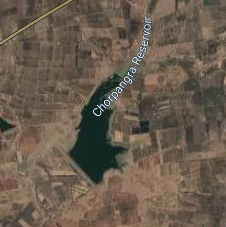
10. Chorpangra. ( LATUTUDE : 20.008033,N, LONGITUDE : 76.364387E )
Map & link uploaded Aug- Sept 2020.
For viewing the surrounding areas and the map page click HERE.
Some information about Chorpangra Irrigation Project.
Chorpangra Reservoir was created as a result of construction of Chorpangra Dam of Chorpangra Irrigation Project . Official Designation of the The Project is " Chorpangra D - 0 3580" . Chorpangra Reservoir is locally also known as " Chorpangra Lake" / " Chorpangra Talav" . Chorpangra Peoject was constructed as part of irrigation projects by Government of Maharashtra the year of completion the year 1984. Nearest city to dam is Lonar and the Dam is situated in Lonar Taluka of Buldana District of Maharashtra . Tambola Project is built on and impounds a Local Nallah .The Project Dam is an Earth-fill Gravity Dam . Purpose of the Project is for irrigation . The length of the Dam is 607 m ( 1991.47 Feet ) . while the height of the dam above lowest foundation is 14.59 m ( 47.86 Feet ) . Detailed information about project spillway is not available . Spillway length is not known . However , measured spillway length is 110 m ( 359 Feet ). Spillway is of other type and it is ungated. The condition of the spillway is not too good due to lese maintenance.Catchment area of Chorpangra Reservoir is not known . Maximum / Gross storage capacity of Chorpangra Reservoir is 2.37 MCM . Live storage capacity is 2.17 MCM . Now a days almost all the water bodies make for good picnic spots Chorpangra lake is also a popular Tourist attraction for its scenic beauty.
( Note : Blue area in normal map corresponds to Maximum / Full Reservoir Level.)
11. Mandwa. ( LATUTUDE : 20.0252098N, LONGITUDE : 76.3337374E )
Map & link uploaded Aug- Sept 2020.
For viewing the surrounding areas and the map page click HERE.
Some information about Mandwa Irrigation Project.
There are four dams with this name in the state of Maharashtra. 1.Near Risod in Washim District,2. Near Sindkhed Raja in Buldhana District 3. Near Kinwat in Nanded District and 4.Near Dharni in Amravati District.
Mandwa Reservoir was created as a result of construction of Mandwa Dam of Mandwa Irrigation Project . Official Designation of the The Project is " Mandwa D - 01376" . Mandwa Reservoir is locally also known as " Mandwa Lake" / " Mandwa Talav" . Mandwa Project was constructed as part of irrigation projects by Government of Maharashtra the year of completion the year 1995. Nearest city to dam is Shindkhed Raja and the Dam is situated in Shindkhed Raja Taluka of Buldana District of Maharashtra . Mandwa Project is built on and impounds a Local Nallah .The Project Dam is an Earth-fill Gravity Dam . Purpose of the Project is for irrigation . The length of the Dam is 663 m ( 2175.2 Feet ) . while the height of the dam above lowest foundation is 18.52 m ( 60.76 Feet ) . Detailed information about project spillway is not available . Spillway length is not known . However measured length of the spillway is 82 m ( 275 Feet ) . Spillway appears to be of other type and ungated . Catchment area of Mandwa Reservoir is not known . Maximum / Gross storage capacity of Mandwa Reservoir is 4.101 MCM . Live storage capacity is 3.25 MCM . Now a days almost all the water bodies make for good picnic spots Mandwa lake is also a popular Tourist attraction for its scenic beauty .
( Note : Blue area in normal map corresponds to Maximum / Full Reservoir Level.)
12. Saokhed Bhoi. ( LATUTUDE : 20.016156,N, LONGITUDE : 76.001283 E )

Map & link uploaded Aug- Sept 2020.
For viewing the surrounding areas and the map page click HERE.
Some information about Saokhed Bhoi Irrigation Project.
Saokhed Bhoi Reservoir was created as a result of construction of Saokhed Bhoi Dam of Saokhed Bhoi Irrigation Project . Official Designation of the The Project is " Saokhed Bhoi D - 04759" . Saokhed Bhoi Reservoir is locally also known as " Saokhed Bhoi Lake" / " Saokhed Bhoi Talav" . Saokhed Bhoi Project was constructed as part of irrigation projects by Government of Maharashtra the year of completion the year 1998 . Nearest city to dam is Deulgaon Raja and the Dam is situated in Deulgaon Raja Taluka of Buldana District of Maharashtra . Saokhed Bhoi Project is built on and impounds Amna River . The Project Dam is an Earth-fill Gravity Dam . Purpose of the Project is for irrigation . The length of the Dam is 1230 m ( 4035.43 Feet ) . while the height of the dam above lowest foundation is 14.23 m ( 46.68 Feet ) . Detailed information about project spillway is not available . Spillway length is not known . However measured length of the spillway is 125 m ( 411 Feet ) . Spillway appears to be of other type and ungated . Catchment area of Saokhed Bhoi Reservoir is not known . Maximum / Gross storage capacity of Saokhed Bhoi Reservoir is not known . Live storage capacity is not known . Now a days almost all the water bodies make for good picnic spots Saokhed Bhoi lake is also a popular Tourist attraction for its scenic beauty .
Saokhed Bhoi Reservoir was created as a result of construction of Saokhed Bhoi Dam of Saokhed Bhoi Irrigation Project . Official Designation of the The Project is " Saokhed Bhoi D - 04759" . Saokhed Bhoi Reservoir is locally also known as " Saokhed Bhoi Lake" / " Saokhed Bhoi Talav" . Saokhed Bhoi Project was constructed as part of irrigation projects by Government of Maharashtra the year of completion the year 1998 . Nearest city to dam is Deulgaon Raja and the Dam is situated in Deulgaon Raja Taluka of Buldana District of Maharashtra . Saokhed Bhoi Project is built on and impounds Amna River . The Project Dam is an Earth-fill Gravity Dam . Purpose of the Project is for irrigation . The length of the Dam is 1230 m ( 4035.43 Feet ) . while the height of the dam above lowest foundation is 14.23 m ( 46.68 Feet ) . Detailed information about project spillway is not available . Spillway length is not known . However measured length of the spillway is 125 m ( 411 Feet ) . Spillway appears to be of other type and ungated . Catchment area of Saokhed Bhoi Reservoir is not known . Maximum / Gross storage capacity of Saokhed Bhoi Reservoir is not known . Live storage capacity is not known . Now a days almost all the water bodies make for good picnic spots Saokhed Bhoi lake is also a popular Tourist attraction for its scenic beauty .
( Note : Blue area in normal map corresponds to Maximum / Full Reservoir Level.)
No comments:
Post a Comment