DAMS IN WARDHA DISTRICT - PART ONE (EDITED).
All 33 blogs covering 380 dams in 11 Districts of Vidarbha Region were edited between Aug & Sept 2020. For details go to blog "Vidarbha Region. Edit-Now - Why". Link here.
There are total of 20 Major Dams ( Height from foundation 10 meters or more ) in Wardha District. Wardha District also has one Barrage Pulgaon). Excluded From dams coverage.
And two wiers ( Dham, Madan) These were researched and data included earlier. However during the edit their serial numbers were removed. And Dams renumbered In part one and two.
Information on these dams is covered in Two Parts
Part One .1.Lal Nalla. 2. Pothara. 3. Pulgaon
Barrage. 4. Rotha - I. 5. Rotha
- II. 6. Madan. 7. Madan Pick Up
Weir 8. Dham. 9. Dham Pick Up
Weir. 10. Panchadhara. 11. Dongargaon. 12. Panjra
Bothli.
Part Two 13. Sawangi. 14. Umri. 15. Bor. 16. Dahegaon ondi. 17. Ambazari. 18. Harashi. 19. Kannamwargram. 20. Kar. 21. Parsodi. 22. Asthi.
1. Lal Nalla. ( LATITUDE : 20.5188404N , LONGITUDE : 79.1189003E )

Map & link uploaded Aug- Sept 2020.
For viewing the surrounding areas and the map page click HERE.
Some information about Lal Nalla Irrigation Project.
Lal Nalla Irrigation Project, Dam's Official Designation is "Lal Nalla D-03118" .Lal Nalla Dam was constructed as part of irrigation projects by Government of Maharashtra in the year 2006 . It is built on Lal Nalla River , nearest city to dam is Samudrapur in Wardha District of Maharashtra . The dam is an Earth fill Dam .The length of dam is 3450 m ( 11318.9 ft ) , while the height of the dam above lowest foundation is 13.9 m ( 45.603 feet ) . Project has spillway of Ogee type . Length of the spillway is 120 m ( 393.701 ft ) .The Dam has 5 Radial Type of spillway gates. It has catchment area of 10.774 thousand hectors. Maximum / Gross storage capacity is 28.1 MCM. Live storage capacity is 26.13 MCM. Now a days almost all the water bodies make for good picnic spots. Lal Nalla Lake is also a popular Tourist attraction for its scenic beauty.
( Note : Blue area in normal map corresponds to Maximum / Full Reservoir Level.)
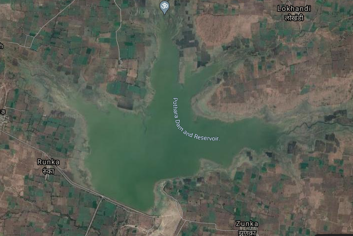
2. Pothara. ( LATITUDE : 20.5630459N, LONGITUDE : 79.0423393E )
Map & link uploaded Aug- Sept 2020.
For viewing the surrounding areas and the map page click HERE.
Some information about Pothara Irrigation Project.
Official Designation of Pothara Dam Irrigation Project is "Pothara Dam , D - 02849 " . However local and popular name is " Pothara Lake / Pothara Talav ". Pothara Dam, is an earthfill dam on Pothara river near Hinganghat in Wardha District in the state of Maharashtra in India.This was built for the purpose of irrigation in 1983.The height of the dam above lowest foundation is 18.21 m ( 59.744 ft ) while the length is 2,306 m ( 7565.617 ft). Project has a Spillway of other type . Length of the spillway is 380 m ( 1246.72 ft ) .The spillway is un-gated. It has catchment area of 20.761 thousand hectors. Maximum / Gross storage capacity is 38.4 MCM. Live storage capacity is 34.72 MCM. Now a days almost all the water bodies make for good picnic spots. Pothara Lake is also a popular Tourist attraction for its scenic beauty
( Note : Blue area in normal map corresponds to Maximum / Full Reservoir Level.).
Pulgaon Barrage. ( LATITUDE : 20.7282912N, LONGITUDE : 78.3086264E )

Map & link uploaded Aug- Sept 2020.
For viewing the surrounding areas and the map page click HERE.
Some information about Pulgaon Barrage Project.
Barrage is a type of Dam which consists of a line of large gates that can be opened or closed to control the amount of water passing the dam.
A key difference between a barrage and a dam is that a dam is built for storing water in a Reservoir, which raises the level of water significantly. A barrage is built for diverting water, and is generally built on flat terrain across wide meandering rivers, raising the water level only a few feet.
When this blog was written, the source website of WRIS did not have any information on this barrage.
Following information added during the edit to add lost maps on 31 August 2020.
Bhumi pujan and ground breaking ceremony was performed twice once in September 2009 and second time on 9 Mat 2010 The work was expected to be completed by 2012. Could not find confirmation about its completion on the date 31 August 2020 when this edit was carried out.
Total capacity if the barrage is 10.80 cubic meters. Useful stock is 9.84 cubic meters. As aresult water will be supplied to 13 villages in the city and its environs including including ammunition depot, which will create an irrigation capacity of 3236 hectares.
The barrage will be 225 meters long, 14.17 meters high and 6.50 meters wide. Water will be stored. There will be 15 doors to release water.
( Note : Blue area in normal map corresponds to Maximum / Full Reservoir Level.)
3. Rotha - I. ( LATITUDE :20.7596453N, LONGITUDE : 78.5527611E )

Map & link uploaded Aug- Sept 2020.
For viewing the surrounding areas and the map page click HERE.
Some information about Rotha - I Irrigation Project.
Information about Rotha- I Irrigation Project.
Rotha- I Irrigation Project, Dam's Official Designation is "Rotha- I D-04718" . Rotha- I Dam was constructed as part of irrigation projects by Government of Maharashtra in the year 1995 . It is built on Local nallah,nearest city to dam is Wardha in Nagpur District of Maharashtra . The dam is an Earth fill Dam .The length of dam is 1008 m ( 3307.087 ft ) , while the height of the dam above lowest foundation is 12.72 m ( 41.7322 feet ) . Project has no proper spillway as such . Dam's catchment area is not known . Maximum / Gross storage capacity is 2.063 MCM. Live storage capacity is 1.975 MCM. Now a days almost all the water bodies make for good picnic spots.
Rotha- I Irrigation Project, Dam's Official Designation is "Rotha- I D-04718" . Rotha- I Dam was constructed as part of irrigation projects by Government of Maharashtra in the year 1995 . It is built on Local nallah,nearest city to dam is Wardha in Nagpur District of Maharashtra . The dam is an Earth fill Dam .The length of dam is 1008 m ( 3307.087 ft ) , while the height of the dam above lowest foundation is 12.72 m ( 41.7322 feet ) . Project has no proper spillway as such . Dam's catchment area is not known . Maximum / Gross storage capacity is 2.063 MCM. Live storage capacity is 1.975 MCM. Now a days almost all the water bodies make for good picnic spots.
( Note : Blue area in normal map corresponds to Maximum / Full Reservoir Level.)
4. Rotha - II. ( LATITUDE : 20.7626951N, LONGITUDE : 78.5419464E )

4. Rotha - II. ( LATITUDE : 20.7626951N, LONGITUDE : 78.5419464E )

Map & link uploaded Aug- Sept 2020.
For viewing the surrounding areas and the map page click HERE.
Some information about Rotha - II Irrigation Project.
Rotha -II Irrigation Project, Dam's Official Designation is "Rotha -II D-04719" .Rotha -II Dam was constructed as part of irrigation projects by Government of Maharashtra in the year 1995 . It is built on Local nallah nearest city to dam is Wardha in Wardha District of Maharashtra . The dam is an Earth fill Dam .The length of dam is 772 m ( 2532.81 ft ) , while the height of the dam above lowest foundation is 12.3 m ( 40.354 feet ) . Project has no proper spillway as such..Dam's catchment area is not known Maximum / Gross storage capacity is 1.076 MCM. Live storage capacity is 1.011 MCM. Now a days almost all the water bodies make for good picnic spots.
Rotha -II Irrigation Project, Dam's Official Designation is "Rotha -II D-04719" .Rotha -II Dam was constructed as part of irrigation projects by Government of Maharashtra in the year 1995 . It is built on Local nallah nearest city to dam is Wardha in Wardha District of Maharashtra . The dam is an Earth fill Dam .The length of dam is 772 m ( 2532.81 ft ) , while the height of the dam above lowest foundation is 12.3 m ( 40.354 feet ) . Project has no proper spillway as such..Dam's catchment area is not known Maximum / Gross storage capacity is 1.076 MCM. Live storage capacity is 1.011 MCM. Now a days almost all the water bodies make for good picnic spots.
( Note : Blue area in normal map corresponds to Maximum / Full Reservoir Level.)
5. Madan. ( LATITUDE : 20.9431642N, LONGITUDE : 78.5394788E )

5. Madan. ( LATITUDE : 20.9431642N, LONGITUDE : 78.5394788E )

Map & link uploaded Aug- Sept 2020.
For viewing the surrounding areas and the map page click HERE.
Some information about Madan Irrigation Project.
Madan Irrigation Dam was constructed as part of much larger Project under Projet code JI 00549 which comprised construction of Madan Pick Up Weir and Left and Right Bank Canals.
The Dam's Official Designation is "Madan D-03099" . Madan Dam was constructed as part of irrigation projects by Government of Maharashtra in the year 2003 . It is built on Madan Nalla / River , nearest city to dam is Arvi in Wardha District of Maharashtra . The dam is an Earth fill Dam .The length of dam is 1291 m ( 4235.564 ft ) , while the height of the dam above lowest foundation is 26.55 m ( 87.1062 feet ) . Project has a Spillway of other type . Length of the spillway is 140 m ( 459.318 ft ) The spillway is un-gated. Dam has catchment area of 4.09 thousand hectors. Maximum / Gross storage capacity is 11.46 MCM. Live storage capacity is 10.56 MCM. Now a days almost all the water bodies make for good picnic spots. Madan Lake is also a popular Tourist attraction for its scenic beauty .
The Dam's Official Designation is "Madan D-03099" . Madan Dam was constructed as part of irrigation projects by Government of Maharashtra in the year 2003 . It is built on Madan Nalla / River , nearest city to dam is Arvi in Wardha District of Maharashtra . The dam is an Earth fill Dam .The length of dam is 1291 m ( 4235.564 ft ) , while the height of the dam above lowest foundation is 26.55 m ( 87.1062 feet ) . Project has a Spillway of other type . Length of the spillway is 140 m ( 459.318 ft ) The spillway is un-gated. Dam has catchment area of 4.09 thousand hectors. Maximum / Gross storage capacity is 11.46 MCM. Live storage capacity is 10.56 MCM. Now a days almost all the water bodies make for good picnic spots. Madan Lake is also a popular Tourist attraction for its scenic beauty .
( Note : Blue area in normal map corresponds to Maximum / Full Reservoir Level.)
Madan Pick Up Weir. ( LATITUDE & LONGITUDE Not available )
6. Dham. ( LATITUDE : 20.9657677N, LONGITUDE : 78.4513092E )

Madan Pick Up Weir. ( LATITUDE & LONGITUDE Not available )
NO SPATERATE MAP UPLOADED AS WIER NOT SEEN.
Some information about Madan Pick Up Weir
Madan Pick Up Wier is not visible/seen in google satellite map.was constructed as part of Madan Tank Project,Project code number: JI00549. Madan Pick Up Wier is 3488 m long and 12.64 m high Pick-up weir with 157.80 m long central ogee-type spillway 12 km distance of the main dam near Wadgaon village in Seloo Taluka. The central spillway is designed to pass maximum flood of 1036.40 cubic meters per second.
A weir is a barrier across a river designed to alter its flow characteristics. In most cases, weirs take the form of obstructions smaller than most conventional dams, which cause water to pool behind them, while allowing water to flow steadily over their tops. Weirs are commonly used to alter the flow of rivers to prevent flooding, measure discharge, and help render rivers navigable.
( Note : Blue area in normal map corresponds to Maximum / Full Reservoir Level.)
6. Dham. ( LATITUDE : 20.9657677N, LONGITUDE : 78.4513092E )

Map & link uploaded Aug- Sept 2020.
For viewing the surrounding areas and the map page clickHERE.
Some information about Dham Irrigation Project.
Dham Irrigation Project, the local name as given in official Web Page of Wardha District , is Mahakali Dam , may be as a popular Mahakali Temple is built just below the Dam.
The Dam's Official Designation is "Dham D-02889" .Dham Dam was constructed as part of irrigation projects by Government of Maharashtra in the year 1986 . It is built on Dham River , nearest city to dam is Arvi in Wardha District of Maharashtra . The dam is an Earth fill Dam .The length of dam is 1728 m ( 5669.291 ft ) , while the height of the dam above lowest foundation is 33.35 m ( 109.416 feet ) . Project has .a Spillway of Chute type . Length of the spillway is 170 m ( 557.743 ft ) The spillway has one spillway gates.Dam's catchment area is not known It has catchment area of 37.133 thousand hectors. Maximum / Gross storage capacity is 62.51 MCM. Live storage capacity is 52.56 MCM. Now a days almost all the water bodies make for good picnic spots. Dham Lake is also a popular Tourist attraction for its scenic beauty and the Mahakali Temple Where lodging and boarding facilities are available.
( Note : Blue area in normal map corresponds to Maximum / Full Reservoir Level.)
7. Dham Pick Up Weir. ( LATITUDE : 20.8127317N, LONGITUDE : 78.5858917E )

7. Dham Pick Up Weir. ( LATITUDE : 20.8127317N, LONGITUDE : 78.5858917E )

Map & link uploaded Aug- Sept 2020.
For viewing the surrounding areas and the map page click HERE.
Some information about Dham Pick Up Weir.
This is Dham Pick-up Weir. Part of Dham River Project , Project code is JI00442.
Other technical Details are not available.
Weir is a barrier across a river designed to alter the flow characteristics. In most cases, weirs take the form of a barrier, smaller than most conventional dams, across a river that causes water to pool behind the structure (not unlike a dam) and allows water to flow over the top. Weirs are commonly used to alter the flow regime of the river, prevent flooding, measure discharge and help render a river navigable. A wier is built some distance downriver from the dam. However in this case Dham pickup wier is almost 15 - 20 K downstream.
( Note : Blue area in normal map corresponds to Maximum / Full Reservoir Level.)
8. Panchadhara. ( LATITUDE : 20.9086712N, LONGITUDE : 78.6031222E )

8. Panchadhara. ( LATITUDE : 20.9086712N, LONGITUDE : 78.6031222E )

Map & link uploaded Aug- Sept 2020.
For viewing the surrounding areas and the map page click HERE.
Some information about Panchadhara Irrigation Project.
Panchadhara Irrigation Project,Dam's Official Designation is "Panchadhara D-01291" .Panchadhara Dam was constructed as part of irrigation projects by Government of Maharashtra in the year 1976 . It is built on.Panchadhara River ...nearest city to dam is Wardha in Wardha District of Maharashtra . The dam is an Earth fill Dam .The length of dam is 1035 m ( 3395.669 ft ) , while the height of the dam above lowest foundation is 27.41 m ( 89.9278 feet ) . Project has a Spillway of other type . Length of the spillway is not known... The spillway is un-gated. It has catchment area of 5.78 thousand hectors. Maximum / Gross storage capacity is 9.68 MCM. Live storage capacity is 8.75 MCM. Now a days almost all the water bodies make for good picnic spots. Panchadhara Lake is also a popular Tourist attraction for its scenic beauty .
Panchadhara Irrigation Project,Dam's Official Designation is "Panchadhara D-01291" .Panchadhara Dam was constructed as part of irrigation projects by Government of Maharashtra in the year 1976 . It is built on.Panchadhara River ...nearest city to dam is Wardha in Wardha District of Maharashtra . The dam is an Earth fill Dam .The length of dam is 1035 m ( 3395.669 ft ) , while the height of the dam above lowest foundation is 27.41 m ( 89.9278 feet ) . Project has a Spillway of other type . Length of the spillway is not known... The spillway is un-gated. It has catchment area of 5.78 thousand hectors. Maximum / Gross storage capacity is 9.68 MCM. Live storage capacity is 8.75 MCM. Now a days almost all the water bodies make for good picnic spots. Panchadhara Lake is also a popular Tourist attraction for its scenic beauty .
( Note : Blue area in normal map corresponds to Maximum / Full Reservoir Level.)
9. Dongargaon. ( LATITUDE : 20.9229624N, LONGITUDE : 78.6813569E )

9. Dongargaon. ( LATITUDE : 20.9229624N, LONGITUDE : 78.6813569E )

Map & link uploaded Aug- Sept 2020.
For viewing the surrounding areas and the map page click HERE.
Some information about Dongargaon Irrigation Project.
There are Total of six dams with the same name i Maharashtra, Other five are located 1, Near Kinwat in Nanded District, 2,Near Rajura in Chandrapur District , 3,Near Aurangabad in Aurangabad District , 4,Near Yeola in Nashik District, and 5 , Near Mangakwedga in Solapur District,
Information about Dongargaon Irrigation Project. of Wardha District .
Dongargaon Irrigation Project, Dam's Official Designation is "Dongargaon D-01325" .Dongargaon Dam was constructed as part of irrigation projects by Government of Maharashtra in the year 1971 . It is built on Nagda Nallah River , nearest city to dam is Wardha in Wardha District of Maharashtra . The dam is an Earth fill Dam .The length of dam is 543 m ( 1781.5 ft ) , while the height of the dam above lowest foundation is 16.98 m ( 55.7086 feet ) . Project has a Spillway of other type.Length of the spillway is not known.The Dam has 3 spillway gates. It has catchment area of 2.07 thousand hectors. Maximum / Gross storage capacity is 4.81 MCM. Live storage capacity is 4.41 MCM. Now a days almost all the water bodies make for good picnic spots. Dongargaon Lake is also a popular Tourist attraction for its scenic beauty .
( Note : Blue area in normal map corresponds to Maximum / Full Reservoir Level.)
10. Panjra Bothli. ( LATITUDE : 20.8946643N, LONGITUDE : 78.3800805E )

For viewing the surrounding areas and the map page click HERE.
10. Panjra Bothli. ( LATITUDE : 20.8946643N, LONGITUDE : 78.3800805E )

Map & link uploaded Aug- Sept 2020.
Some information about Panjra Bothli Irrigation Project.
Panjra Bothli Irrigation Project, Dam's Official Designation is "Panjra Bothli D-06037" .Panjra Bothli Dam was constructed as part of irrigation projects by Government of Maharashtra in the year 1975 . It is built on Local nallah , nearest city to dam is Arvi in Wardha District of Maharashtra . The dam is an Earth fill Dam .The length of dam is 380 m ( 1246.72 ft ) , while the height of the dam above lowest foundation is 17.65 m ( 57.9068 feet ) . Project has no proper spillway as such . Dam's catchment area is not known . Maximum / Gross storage capacity is 2.056 MCM. Live storage capacity is 1.95 MCM. Now a days almost all the water bodies make for good picnic spots. Panjra Bothli Lake is also a popular place locally.
Panjra Bothli Irrigation Project, Dam's Official Designation is "Panjra Bothli D-06037" .Panjra Bothli Dam was constructed as part of irrigation projects by Government of Maharashtra in the year 1975 . It is built on Local nallah , nearest city to dam is Arvi in Wardha District of Maharashtra . The dam is an Earth fill Dam .The length of dam is 380 m ( 1246.72 ft ) , while the height of the dam above lowest foundation is 17.65 m ( 57.9068 feet ) . Project has no proper spillway as such . Dam's catchment area is not known . Maximum / Gross storage capacity is 2.056 MCM. Live storage capacity is 1.95 MCM. Now a days almost all the water bodies make for good picnic spots. Panjra Bothli Lake is also a popular place locally.
( Note : Blue area in normal map corresponds to Maximum / Full Reservoir Level.)
Hello sir my name is Irfan sheikh I am a Ph.D. student. doing research on Bor reservoir if you Have any information related to Bor Dharan kindly contact me on my no. 9730949115
ReplyDelete