DAMS IN BULDHANA DISTRICT - PART FIVE (EDITED).
All 33 blogs covering 380 dams in 11 Districts of Vidarbha Region were edited between Aug & Sept 2020. For details go to blog "Vidarbha Region. Edit-Now - Why". Link here.
There are total of 60 Major Dams ( Height from foundation 10 meters or more ) in Buldhana District.
Information on these dams is covered in Five Parts.
Part One. 1.Gandhari. 2.Shivanijat. 3.Titwi. 4.Pimpal ner.ner. 5. Ambhora. 6.Vidrupa. 7. Garkhed. 8. Pimparkhed. 9.Tambola. 10.Chorpangra. 11. Mandwa. 12. Saokhed Bhoi.
Part Two.13. Keshavshivani. 14. Khadakpurna. 15. Shivani Armal. 16. Ancharwadi -1. 17. Ancharwadi - II 18. Misalwadi 19. Kalapvihir. 20. Jagdari. 21. Sawangimali -1. 22. Sawangimali 2. 23. Koradi .24. Khandala. 25. Pentakali. 26. Kalmeshwar.
Part Three. 27. Patoda. 28. Telhara. 29. Haralkhed. 30. Kawala . 31. Utawali. 32.Mun. 33. Torna. 34. Fattepur. 35. Ganeshpur. 36. Hiwarkhed. 37. Mas . 38. Matla. 39. Pangrikesapur.
Part Four. 40. Kardi. 41. Gyanganga. 42. Shekapur. 43. Zari. 44. Dahid / Dahad. 45. Paldhag. 46. Botha / Pimpri. 47. Garadgaon. 48. Pimpalgaon Nath. 49. Dhamangaon Deshmukh / Kothali. 50 . Takli.
Part Five. 51. Kandari. 52 . Borjawala. 53 . Wari. 54 . Nalganga. 55 . Kolhigolar. 56 . Khandwa. 57. Dhanora. 58 . Rajura. 59 . Godada / Gorada.60.Jigaon.

Map & link uploaded Aug- Sept 2020.
For viewing the surrounding areas and the map page click HERE.
Kandari Reservoir got created as a result of construction of Kandari Dam of Kandari irrigation Project . Official Designation of the The Project is " Kandari D - 04053" . Locally this is also known as " Kandari Talav " or " Kandari Lake" . Project was constructed as part of irrigation projects by the Government of Maharashtra in the year 1985 and impounds a Local Nallah . Nearest city to dam is Nandura and the Dam is situated in Khamgaon Taluka of Buldana District of Maharashtra . The dam is earth fill gravity dam. The purpose of the dam and project is Irrigation . The length of the Dam is 1184 m ( 3884.51 Feet ) . while the height of the dam above lowest foundation is 14.93 m (48.98 Feet ) . Information on Spillway is not available . Length of the spillway is not known . At least whatever is left of what was once a Spillway , is in a very bad condition being eroded and washed away . Catchment area of Kandari Reservoir is not known. Maximum / Gross storage capacity of Kandari Reservoir is not known . Live storage capacity is not known . Now a days almost all the water bodies make for good picnic spots Takali Reservoir / lake is also a popular Tourist attraction for its scenic beauty .
( Note : Blue area in normal map corresponds to Maximum / Full Reservoir Level. )
52 . Borjawala. ( LATITUDE :20.7226417N, LONGITUDE :76.3700223E )

Map & link uploaded Aug- Sept 2020.
For viewing the surrounding areas and the map page click HERE.
Borjawala Reservoir got created as a result of construction of Borjawala Dam of Borjawala irrigation Project . Official Designation of the The Project is " Borjawala D - 03497" . Locally this is also known as " Borjawala Talav " or " Borjawala Lake" . Project was constructed as part of irrigation projects by the Government of Maharashtra in the year 1988 and impounds a Local Nallah . Nearest city to dam is Khamgaon and the Dam is situated in Khamgaon Taluka of Buldana District of Maharashtra . The dam is earth fill gravity dam. The purpose of the dam and project is Irrigation . The length of the Dam is 840 m ( 2755.91 Feet ) . while the height of the dam above lowest foundation is 12.42 m ( 40.74 Feet ) . Information on Spillway is not available . Length of the spillway is not known . At least whatever is left of what was once a Spillway , is in a very bad condition being eroded and washed away . Only traces pf spillway and canal exists. Catchment area of Borjawala Reservoir is not known. Maximum / Gross storage capacity of Borjawala Reservoir is not known . Live storage capacity is not known . Now a days almost all the water bodies make for good picnic spots Borjawala Reservoir / lake is also a popular Tourist attraction for its scenic beauty .
( Note : Blue area in normal map corresponds to Maximum / Full Reservoir Level. )
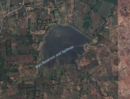
53 . Wari. ( LATITUDE : 20.7036147N, LONGITUDE : 76.0919952E )
Map & link uploaded Aug- Sept 2020.
For viewing the surrounding areas and the map page click HERE.
Wari Reservoir was created as a result of construction of Wari Dam of Wari irrigation Project . Official Designation of the The Project is " Wari D - 05066" . Locally this is also known as " Wari Talav " or " Wari Lake" . Project was constructed as part of irrigation projects by the Government of Maharashtra in the year 1973 and impounds a Local Nallah . Nearest city to dam is Motala and the Dam is situated in Motala Taluka of Buldana District of Maharashtra . The dam is earth fill gravity dam. The purpose of the dam and project is Irrigation . The length of the Dam is 538 m ( 1765.09 Feet ) . while the height of the dam above lowest foundation is 13.38 m ( 43.89 Feet ) . Information on Spillway is not available . Length of the spillway is not known . At least whatever is left of what was once a Spillway , is in a very bad condition being eroded and washed away . Only traces pf spillway and canal exists. Catchment area of Wari Reservoir is not known. Maximum / Gross storage capacity of Wari Reservoir 2.01 MCM . Live storage capacity is 1.45 MCM . Now a days almost all the water bodies make for good picnic spots Wari Reservoir / lake is also a popular Tourist attraction for its scenic beauty .
( Note : Blue area in normal map corresponds to Maximum / Full Reservoir Level. )
54 . Nalganga. ( LATITUDE : 20.7278597N, LONGITUDE : 76.1836624E )

Map & link uploaded Aug- Sept 2020.
For viewing the surrounding areas and the map page click HERE.
Nalganga Reservoir was created as a result of construction of Nalganga Dam of Nalganga irrigation Project . Official Designation of the The Project is " Nalganga D - 01216" . Locally this is also known as " Nalganga Talav " or " Nalganga Lake" . Project was constructed as part of irrigation projects by the Government of Maharashtra in the year 1967 and impounds Nalganga River .. Nearest city to dam is Malkapur and the Dam is situated in Motala Taluka of Buldana District of Maharashtra . The dam is earth fill gravity dam. The purpose of the dam and project is Irrigation . The length of the Dam is 2516 m ( 8254.59 Feet ) . while the height of the dam above lowest foundation is 29.8 m ( 97.76 Feet ) . Length of the spillway is 160 94 m ( 520.01 Feet.) . Spillway is of Ogee type . The spillway has Eleven Radial type spillway Gates. Catchment area of Nalganga Reservoir is 31.598 Thousand Hectors. Maximum / Gross storage capacity of Nalganga Reservoir 71.86 MCM . Live storage capacity is 70.54 MCM . Now a days almost all the water bodies make for good picnic spots Nalganga Reservoir / lake is also a popular Tourist attraction for its scenic beauty .
( Note : Blue area in normal map corresponds to Maximum / Full Reservoir Level. )
55 . Kolhigolar. ( LATITUDE : 20.738576N, LONGITUDE : 76.0656881E )

Map & link uploaded Aug- Sept 2020.
For viewing the surrounding areas and the map page click HERE.
Kolhigolar Reservoir got created as a result of construction of Kolhigolar Dam of Kolhigolar irrigation Project . Official Designation of the The Project is " Kolhigolar D - 04191" . Locally this is also known as " Kolhigolar Talav " or " Kolhigolar Lake" . Project was constructed as part of irrigation projects by the Government of Maharashtra in the year 1979 and impounds a Local Nallah . Nearest city to dam is Kolhigolar and the Dam is situated in Motala Taluka of Buldana District of Maharashtra . The dam is earth fill gravity dam. The purpose of the dam and project is Irrigation . The length of the Dam is 856 m ( 2808.4 Feet ) . while the height of the dam above lowest foundation is 14.3 m ( 46.35 Feet ) . Information on Spillway is not available . Length of the spillway is not known . At least whatever is left of what was once a Spillway , is in a very bad condition being eroded and partly washed away and only spillway canal exists . Catchment area of Kolhigolar Reservoir is not known . Maximum / Gross storage capacity of Kolhigolar Reservoir 1.72 MCM . Live storage capacity is 1.23 MCM . Now a days almost all the water bodies make for good picnic spots Kolhigolar Reservoir / lake is also a popular Tourist attraction for its scenic beauty .
( Note : Blue area in normal map corresponds to Maximum / Full Reservoir Level. )
56 . Khandwa. ( LATITUDE : 20.622857N, LONGITUDE : 76.042520E )

Map & link uploaded Aug- Sept 2020.
For viewing the surrounding areas and the map page click HERE
Khandwa Reservoir was created as a result of construction of Khandwa Dam of Khandwa irrigation Project . Official Designation of the The Project is " Khandwa D - 04151" . Locally this is also known as " Khandwa Talav " or " Khandwa Lake" . Project was constructed as part of irrigation projects by the Government of Maharashtra in the year 1970 and impounds a Local Nallah . Nearest city to dam is Khandwa and the Dam is situated in Motala Taluka of Buldana District of Maharashtra . The dam is earth fill gravity dam. The purpose of the dam and project is Irrigation . The length of the Dam is 1108 m ( 3635.17 Feet ) . while the height of the dam above lowest foundation is 14.97 m ( 49.11 Feet ) . Information on Spillway is not available . Length of the spillway is not known . At least whatever is left of what was once a Spillway , is in a very bad condition being eroded and partly washed away and only spillway canal exists . Catchment area of Khandwa Reservoir is not known . Maximum / Gross storage capacity of Khandwa Reservoir is not known . Live storage capacity is not known . Now a days almost all the water bodies make for good picnic spots Khandwa Reservoir / lake is also a popular Tourist attraction for its scenic beauty .
( Note : Blue area in normal map corresponds to Maximum / Full Reservoir Level. )
57. Dhanora. ( LATITUDE : 21.0693834N, LONGITUDE : 76.4639854E )

Map & link uploaded Aug- Sept 2020.
For viewing the surrounding areas and the map page click HERE.
Dhanora Reservoir was created as a result of construction of Dhanora Dam of Dhanora irrigation Project . Official Designation of the The Project is " Dhanora D - 03665" . Locally this is also known as " Dhanora Talav " or " Dhanora Lake" . Project was constructed as part of irrigation projects by the Government of Maharashtra in the year 1969 and impounds a Local Nallah . Nearest city to dam is Jalgaon Jamod and the Dam is situated in Jalgaon Taluka of Buldana District of Maharashtra . The dam is earth fill gravity dam. The purpose of the dam and project is Irrigation . The length of the Dam is 268 m ( 879.26 Feet ) . while the height of the dam above lowest foundation is 19.24 m ( 63.12 Feet ) . Information on Spillway is not available . Length of the spillway is not known . At least whatever is left of what was once a Spillway , is in a very bad condition being eroded and partly washed away . Catchment area of Dhanora Reservoir is not known . Maximum / Gross storage capacity of Dhanora Reservoir is 0.978 m MCM . Live storage capacity is 0.89 MCM . Now a days almost all the water bodies make for good picnic spots Dhanora Reservoir / lake is also a popular Tourist attraction for its scenic beauty .
( Note : Blue area in normal map corresponds to Maximum / Full Reservoir Level. )
58 . Rajura. ( LATITUDE : 21.073388N, LONGITUDE : 76.4939404E )

Map & link uploaded Aug- Sept 2020.
For viewing the surrounding areas and the map page click HERE.
Rajura Reservoir was created as a result of construction of Rajura Dam of Rajura irrigation Project . Official Designation of the The Project is " Rajura D - 04676" . The project consists of two separate dams. Locally this is also known as " Rajura Talav " or " Rajura Lake" . Project was constructed as part of irrigation projects by the Government of Maharashtra in the year 1978 and impounds a Local Nallah . Nearest city to dam is Jalgaon Jamod and the Dam is situated in Jalgaon Taluka of Buldana District of Maharashtra . The dam is earth fill gravity dam. The purpose of the dam and project is Irrigation . Total length of the Dam both the dams is 524 m ( 1719.16 Feet ) . while the height of the dam above lowest foundation is 18.75 m ( 61.51Feet ) . Information on Spillway is not available . Length of the spillway is not known . At least whatever is left of what was once a Spillway , is in a very bad condition being eroded and partly washed away .Traces of Spillway and spillway canal exist. Catchment area of Rajura Reservoir is not known . Maximum / Gross storage capacity of Rajura Reservoir is 3.703 MCM . Live storage capacity is 3.39 MCM . Now a days almost all the water bodies make for good picnic spots Rajura Reservoir / lake is also a popular Tourist attraction for its scenic beauty .
( Note : Blue area in normal map corresponds to Maximum / Full Reservoir Level. )
59 . Godada / Gorada. ( LATITUDE : 21.0989346N, LONGITUDE : 76.5153337E )

Map & link uploaded Aug- Sept 2020.
For viewing the surrounding areas and the map page click HERE.
Name given in official web site is "Godada" . However it appears that locally the place is called "Gorada" . Official name used here.
Godada Reservoir was created as a result of construction of Godada Dam of Godada irrigation Project . Official Designation of the The Project is " Godada D - 03878" . Locally this is also known as " Godada Talav " or " Godada Lake" . Project was constructed as part of irrigation projects by the Government of Maharashtra in the year 1973 and impounds a Local Nallah . Nearest city to dam is Jalgaon Jamod and the Dam is situated in Jalgaon Taluka of Buldana District of Maharashtra . The dam is earth fill gravity dam. The purpose of the dam and project is Irrigation . Length of the Dam is 975 m ( 3198.82 Feet ) . while the height of the dam above lowest foundation is 15.64 m ( 51.31Feet ) . Information on Spillway is not available . Length of the spillway is not known . At least whatever is left of what was once a Spillway , is in a very bad condition being eroded and partly washed away .Traces of Spillway and spillway canal exist. Catchment area of Godada Reservoir is not known . Maximum / Gross storage capacity of Godada Reservoir is 1.896 MCM . Live storage capacity is 1.771 MCM . Now a days almost all the water bodies make for good picnic spots Godada Reservoir / lake is also a popular Tourist attraction for its scenic beauty .
( Note : Blue area in normal map corresponds to Maximum / Full Reservoir Level. )
60.Jigaon. ( LATITUDE : 20.9461702N, LONGITUDE : 76.3738203E )

Map & link uploaded Aug- Sept 2020.
AS IN JUL2013 WORK STILL GOING ON FAR FROM COMPLETE.
Followng text added in edit of Aug- Sept 2020.
Jigaon and Goshikhurd are most ambitious biggest irrigation projects in Vidarbha Region Both the projects have been mired in contoverseries, cost overruns and even after work delays of decades are still not complete.
Following inforrmation, from various sources is included in this blog during the edit on 03 September 2020.
Based on Loksatta report of 1 Sept 2020.
Decision for the project finalised and sanctioned in 1999.
Total 30 villages completely nd 15 villages partially were going to be affected by Jigaon Dam. Land acquisition and resettelment of these vilages was to be done in 5 stages.
In the first stage, as on 1 September 2020, out of 19 villages, resettelment land for only 17 villages has been identified as yet.
No one can see when the remaining 4 stages can be completed.
Based on Times of India 31 Jul 2018.
Project cost in 1997 was projected at Rs 699 crores. In the last to decades the estimates have jumped over 18 times to 12662 crores.
AS IN 03 sept 20, WORK STILL FAR FROM COMPLETE.
No comments:
Post a Comment