DAMS IN AKOLA DISTRICT - PART ONE. (EDITED)
All 33 blogs covering 380 dams in 11 Districts of Vidarbha Region were edited between Aug & Sept 2020. For details go to blog "Vidarbha Region. Edit-Now - Why". Link here.
There are total of 27 Major Dams ( Height from foundation 10 meters or more ) in Akola District.
Information on these dams is covered in Two Parts.
Part One. 1. Wan/Wari/Hanuman Sagar. 2. Chinchpani. 3. Khirkund. 4.Popatkhed.
5. Bhilkhed. 6. Dharur. 7. Borgaon Manju. 8. Sisaudegaon. 9. Shivankhurd. 10. Pimpalsenda. 11. Uma. 12. Kanadi.
13. Ghota. 14. Mozari.
Part Two. 15.Morhal.
16.Pimpalgaon Chambhare. 17. Pimpalgaon Hande. 18.Sawarkhed. 19.Nandkhed.
20.Katepurna.21.Hatola. 22.Januna. 23.Tuljapur. 24.Patur.
25.Nirguna. 26.Gawandgaon.
27.Vishwamitri.
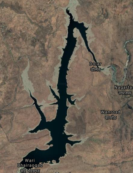
1. Wan/Wari/Hanuman Sagar. ( LATITUDE : 21.1842917N, LONGITUDE : 76.7736626E )
Map & link uploaded Aug- Sept 2020.
For viewing the surrounding areas and the map page click HERE.
Name given in official web site is "Wan" . However it appears that locally the place is called "Wari" and the local name of the Project is " Hanuman Sagar ". Official name is used here
Wan Reservoir was created as a result of construction of Wan Dam of Wan irrigation Project . Official Designation of the The Project is " Wan D - 03007" . Locally this is also known as " Wan Talav " or " Wan Lake" . Project was constructed as part of irrigation projects by the Government of Maharashtra in the year 2000 and impounds Wan River . Nearest city to dam is Akola and the Dam is situated in Telhara Taluka of Akola District of Maharashtra . The dam is earth fill gravity + Masonry dam. The purpose of the dam and project is Irrigation , Hydroelectricity and drinking water supply . The dam is divided in two portions by the Spillway. The measured length of portion on Left ( Western Side ) of the spillway is 144 m ( 473 Feet ) + measured length of the portion Right ( Eastern Side ) of the spillway is 269 m ( 883 Feet ) . The Total length of the Dam , including the Spillway is 500 m ( 1641 Feet ) . while the height of the dam above lowest foundation is 67.65 m ( 222 Feet ) .
The spillway length is 87 m ( 286 Feet ) . Spillway is of Ogee Type and the spillway has SIX Radial type of spillway gates. Catchment area of Wan Reservoir is 27.894 Thousand Hectors . Maximum / Gross storage capacity of Wan Reservoir is 83.465 MCM . Live storage capacity is 81.955 MCM . Now a days almost all the water bodies make for good picnic spots Wan Reservoir / lake is also a popular Tourist attraction for its scenic beauty .
.( Note : Blue area in normal map corresponds to Maximum / Full Reservoir Level. )
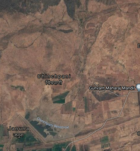
2. Chinchpani. ( LATITUDE : 21.220061N, LONGITUDE : 77.1453524E )
Map & link uploaded Aug- Sept 2020.
For viewing the surrounding areas and the map page click HERE.
Chinchpani Reservoir was created as a result of construction of Chinchpani Dam of Chinchpani irrigation Project . Official Designation of the The Project is " Chinchpani D - 03568" . Locally this is also known as " Chinchpani Talav " or " Chinchpani Lake" . Project was constructed as part of irrigation projects by the Government of Maharashtra in the year 1998 and impounds a Local Nallah . Nearest city to dam is Akot and the Dam is situated in Akot Taluka of Akola District of Maharashtra . The Dam is an Earth-fill Gravity Dam . Purpose of the Project is for irrigation . The length of the Dam is 1035 m ( 3396 Feet ) . while the height of the dam above lowest foundation is 17.25 m ( 57 Feet ) . Information on Spillway is not available . Spillway length is not known . However measured length of the spillway is 49 m ( 161 Feet ) .Spillway is now in damaged condition , but appears to be of other type and is not gated . Catchment area of Chinchpani Reservoir is not known . Maximum / Gross storage capacity of Chinchpani Reservoir is 2.27 MCM . Live storage capacity is 2.11 MCM . Now a days almost all the water bodies make for good picnic spots Chinchpani Reservoir / lake is also a popular Tourist attraction for its scenic beauty .
.( Note : Blue area in normal map corresponds to Maximum / Full Reservoir Level. )
3. Khirkund. ( LATITUDE : 21.2212012N, LONGITUDE : 77.1762943E )

Map & link uploaded Aug- Sept 2020.
For viewing the surrounding areas and the map page click HERE.
Official Designation of Khirkund Dam Irrigation Project is " Khirkund Dam , D - 04171 " . However local and popular name is " Khirkund Lake / Khirkund Talav ". Khirkund Dam was constructed as parts of Irrigation Projects by the Government of Maharashtra in the year 1999. It is built on and impounds Arr River . Nearest city to dam is Akot in Amravati , Taluka Anjangaon Surji , District of Maharashtra . The dam is an Earth fill .The Length of dam is 1419 m ( 4655.512 Feet ) , while the Height of the dam above lowest foundation is 33.3 m ( 109.252 Feet ) . Any type of information about the Project Spillway is not available at all. Length of the Spillway is not known. The Dam has ungated spillway. .Dam's catchment area is not known . Maximum / Gross storage capacity is 5.608 MCM. Live storage capacity is not known. Now a days almost all the water bodies make for good picnic spots Khirkund Lake is also a popular picnic spot for its scenic beauty .
.( Note : Blue area in normal map corresponds to Maximum / Full Reservoir Level. )
4.Popatkhed. ( LATITUDE : 21.2049782N, LONGITUDE : 77.0834255E )
4.Popatkhed. ( LATITUDE : 21.2049782N, LONGITUDE : 77.0834255E )

Map & link uploaded Aug- Sept 2020.
Popatkhed Reservoir was created as a result of construction of Popatkhed Dam of Popatkhed irrigation Project . Official Designation of the The Project is " Popatkhed D - 04646" . Locally this is also known as " Popatkhed Talav " or " Popatkhed Lake" . Project was constructed as part of irrigation projects by the Government of Maharashtra in the year 2005 and impounds Dather River . Nearest city to dam is Akot and the Dam is situated in Akot Taluka of Akola District of Maharashtra . The Dam is an Earth-fill Gravity Dam . Purpose of the Project is for irrigation . Length of the dam is not known . However Dam consists of two bunds and measured lengths are , 778 m ( 2553 Feet ) and 1100 m ( 3609 Feet ) . Total length of two bunds , ie , of the Dam is 1878 m ( 6161 Feet ) . while the height of the dam above lowest foundation is 42.6 m ( 140 Feet ) . Information on Spillway is not available . Spillway length is not known . However measured length of the spillway is 69 m ( 228 Feet ) .Spillway is type is not known and is gated Gate type is not known. . Catchment area of Chinchpani Reservoir is not known . Maximum / Gross storage capacity of Chinchpani Reservoir is 12.192 MCM . Live storage capacity is 10.709 MCM . Now a days almost all the water bodies make for good picnic spots Chinchpani Reservoir / lake is also a popular Tourist attraction for its scenic beauty .
.( Note : Blue area in normal map corresponds to Maximum / Full Reservoir Level. )
5. Bhilkhed. ( LATITUDE : 21.2040979N, LONGITUDE : 77.1175003E )

Map & link uploaded Aug- Sept 2020.
For viewing the surrounding areas and the map page click HERE.
Bhilkhed Reservoir was created as a result of construction of Bhilkhed Dam of Bhilkhed irrigation Project . Official Designation of the The Project is " Bhilkhed D - 03436" . Locally this is also known as " Bhilkhed Talav " or " Bhilkhed Lake" . Project was constructed as part of irrigation projects by the Government of Maharashtra in the year 1985 and impounds a Local nallah . Nearest city to dam is Akot and the Dam is situated in Akot Taluka of Akola District of Maharashtra . The Dam is an Earth-fill Gravity Dam . Purpose of the Project is for irrigation . Length of the dam is 1090 m ( 3576 Feet ) . while the height of the dam above lowest foundation is 11.6 m ( 38 Feet ) . Information on Spillway is not available . Length of the spillway is not known . At least whatever is left of what was once a Spillway , is in a very bad condition being eroded and washed away .Even part of the Dam has also been washed away. Catchment area of Bhilkhed Reservoir is not known . Maximum / Gross storage capacity of Bhilkhed Reservoir is 0.91 MCM . Live storage capacity is 0.84 MCM . Now a days almost all the water bodies make for good picnic spots Bhilkhed Reservoir / lake is also a popular Tourist attraction for its scenic beauty .
.( Note : Blue area in normal map corresponds to Maximum / Full Reservoir Level. )
6. Dharur. ( LATITUDE : 21.1894536N, LONGITUDE : 77.0569897E)

Map & link uploaded Aug- Sept 2020.
For viewing the surrounding areas and the map page click HERE.
Official Designation of the The Project is " Dharur D - 03671" . Locally this is also known as " Dharur Talav " or " Dharur Lake" . Project was constructed as part of irrigation projects by the Government of Maharashtra in the year 1988 and impounds a Local nallah . Nearest city to dam is Akot and the Dam is situated in Akot taluka of Akola District of Maharashtra . The Dam is an Earth-fill Gravity Dam . Purpose of the Project is for irrigation . Length of the dam is 1038 m ( 3406 Feet ) . while the height of the dam above lowest foundation is 12.92 m ( 43 Feet ) .Information on Spillway is not available . Spillway length is not known . However measured length of the spillway is 51 m ( 169Feet ) .Spillway appears to be of other type and is not gated.
Catchment area of Dharur Reservoir is not known . Maximum / Gross storage capacity of Dharur Reservoir is 0.93 MCM . Live storage capacity is 0.85 MCM . Now a days almost all the water bodies make for good picnic spots Dharur Reservoir / lake is also a popular Tourist attraction for its scenic beauty .
.( Note : Blue area in normal map corresponds to Maximum / Full Reservoir Level. )
7. Borgaon Manju. ( LATITUDE : 20.6946222N, LONGITUDE : 77.1378422E )

Map & link uploaded Aug- Sept 2020.
For viewing the surrounding areas and the map page click HERE.
Borgaon Manju Reservoir was created as a result of construction of Borgaon Manju Dam of Borgaon Manju irrigation Project . Official Designation of the The Project is " Borgaon Manju D - 034921" . Locally this is also known as " Borgaon Talav " or " Borgaon Lake" . Project was constructed as part of irrigation projects by the Government of Maharashtra in the year 1976 and impounds a Local nallah . Nearest city to dam is Akola and the Dam is situated in Akola taluka of Akola District of Maharashtra . The Dam is an Earth-fill Gravity Dam . Purpose of the Project is for irrigation . Length of the dam is 578 m ( 1896 Feet ) . while the height of the dam above lowest foundation is 14.5 m ( 48 Feet ) .Information on Spillway is not available . Spillway length is not known . However measured length of the spillway is 105 m ( 345 Feet ) .Spillway is now in damaged condition , but appears to be of other type and is not gated. Catchment area of Borgaon Manju Reservoir is not known . Maximum / Gross storage capacity of Borgaon Manju Reservoir is 1.143 MCM . Live storage capacity is 1.104 MCM . Now a days almost all the water bodies make for good picnic spots Borgaon Manju Reservoir / lake is also a popular Tourist attraction for its scenic beauty .
.( Note : Blue area in normal map corresponds to Maximum / Full Reservoir Level. )
8. Sisaudegaon. ( LATITUDE : 20.6645898N, LONGITUDE : 77.1145821E )

Map & link uploaded Aug- Sept 2020.
For viewing the surrounding areas and the map page click here.
Locally this place is also known as "Masa Lake ,Masa Reservoir or Masa Dam" Here we will use Sisaudegaon
Sisaudegaon Reservoir was created as a result of construction of Sisaudegaon Dam of Sisaudegaon irrigation Project . Official Designation of the The Project is " Sisaudegaon D - 04852" . Locally this is also known as " Sisaudegaon Talav " or " Sisaudegaon Lake" . Project was constructed as part of irrigation projects by the Government of Maharashtra in the year 1979 and impounds a Local nallah . Nearest city to dam is Akola and the Dam is situated in Akola taluka of Akola District of Maharashtra . The Dam is an Earth-fill Gravity Dam . Purpose of the Project is for irrigation . Length of the dam is 462 m ( 1516Feet ) . while the height of the dam above lowest foundation is 16.6 m ( 52.5 Feet ) .Information on Spillway is not available . Spillway length is not known . However measured length of the spillway is 31 m ( 102 Feet ) .Spillway is now in damaged condition , but appears to be of other type and is not gated. Catchment area of Sisaudegaon Reservoir is not known . Maximum / Gross storage capacity of Sisaudegaon Reservoir is 1.01 MCM . Live storage capacity is 0.85 MCM . Now a days almost all the water bodies make for good picnic spots Sisaudegaon Reservoir / lake is also a popular Tourist attraction for its scenic beauty .
.( Note : Blue area in normal map corresponds to Maximum / Full Reservoir Level. )
9. Shivankhurd. ( LATITUDE : 20.6407363N, LONGITUDE : 77.441597E )

Map & link uploaded Aug- Sept 2020.
For viewing the surrounding areas and the map page click HERE.
Shivankhurd Reservoir was created as a result of construction of Shivankhurd Dam of Shivankhurd Irrigation Project . Official Designation of the The Project is " Shivankhurd D - 03959" . Locally this is also known as " Shivankhurd Talav " or " Shivankhurd Lake" . Project was constructed as part of irrigation projects by the Government of Maharashtra in the year 1995 and impounds a Local nallah . Nearest city to dam is Murtizapur and the Dam is situated in Murtizapur taluka of Akola District of Maharashtra . The Dam is an Earth-fill Gravity Dam . Purpose of the Project is for irrigation . The dam is divided in two portions by the Spillway. The measured length of portion Left ( Western Side ) of the spillway is 240 m ( 786 Feet ) + measured length of the Right portion ( Eastern Side ) of the spillway is 1747 m ( 3035 Feet ) . The measured length of The spillway is 113 m ( 371 Feet ) . The Total length of the Dam , including the Spillway is 2100 m ( 6890 Feet ) . while the height of the dam above lowest foundation is 15.71 m ( 52 Feet ) . Catchment area of Shivankhurd Reservoir is not known . Maximum / Gross storage capacity of Shivankhurd Reservoir is 4.188 MCM . Live storage capacity as is given is not known. Now a days almost all the water bodies make for good picnic spots . Shivankhurd Reservoir / lake is also a popular Tourist attraction for its scenic beauty .
.( Note : Blue area in normal map corresponds to Maximum / Full Reservoir Level. )
10. Pimpalsenda. ( LATITUDE : 20.6119986N, LONGITUDE : 77.4082303E )

Map & link uploaded Aug- Sept 2020.
For viewing the surrounding areas and the map page click HERE.
Pimpalsenda Reservoir was created as a result of construction of Pimpalsenda Dam of Pimpalsenda irrigation Project . Official Designation of the The Project is " Pimpalsenda D - 04604" . Locally this is also known as " Pimpalsenda Talav " or " Pimpalsenda Lake" . Project was constructed as part of irrigation projects by the Government of Maharashtra in the year 1981 and impounds a Local nallah . Nearest city to dam is Murtijapur and the Dam is situated in Murtijapur taluka of Akola District of Maharashtra . The Dam is an Earth-fill Gravity Dam . Purpose of the Project is for irrigation . Length of the dam is 960 m ( 3150 Feet ) . while the height of the dam above lowest foundation is 14.34 m ( 47 Feet ) .Information on Spillway is not available . Spillway length is not known . However measured length of the spillway is 128 m ( 420 Feet ) .Spillway is now in damaged condition , but appears to be of other type and is not gated. Catchment area of Pimpalsenda Reservoir is not known . Maximum / Gross storage capacity of Pimpalsenda Reservoir is 2,65 MCM . Live storage capacity is 1,28 MCM . Now a days almost all the water bodies make for good picnic spots Pimpalsenda Reservoir / lake is also a popular Tourist attraction for its scenic beauty .
.( Note : Blue area in normal map corresponds to Maximum / Full Reservoir Level. )
11. Uma. ( LATITUDE : 20.6020969N, LONGITUDE : 77.3935318E )

Map & link uploaded Aug- Sept 2020.
Dam on Uma river at Murtajapur / Karanja tehsil Border
It is on Uma River, a tributory of Purna River that joins Tapi (Tapti) River
Uma Reservoir was created as a result of construction of Uma Dam of Uma irrigation Project . Official Designation of the The Project is " Uma D - 01379" . Locally this is also known as " Uma Talav " or " Uma Lake" . Project was constructed as part of irrigation projects by the Government of Maharashtra in the year 1979 and impounds Uma River . Nearest city to dam is Murtijapur and the Dam is situated in Murtijapur taluka of Akola District of Maharashtra . The Dam is an Earth-fill Gravity Dam . Purpose of the Project is for irrigation . Length of the dam is 2140 m ( 7021 Feet ) . while the height of the dam above lowest foundation is 20.42 m ( 67 Feet ) . Information on Spillway is not available . Spillway length is not known . However measured length of the spillway is 159 m ( 523 Feet ) .Spillway is now in damaged condition , but appears to be of other type and is not gated. Catchment area of Uma Reservoir is not known . Maximum / Gross storage capacity of Uma Reservoir is 14.01 MCM . Live storage capacity is 11.69 MCM . Now a days almost all the water bodies make for good picnic spots Uma Reservoir / lake is also a popular Tourist attraction for its scenic beauty .
.( Note : Blue area in normal map corresponds to Maximum / Full Reservoir Level. )
12. Kanadi. ( LATITUDE : 20.6048285N, LONGITUDE : 77.3322272E )

Map & link uploaded Aug- Sept 2020.
For viewing the surrounding areas and the map page click HERE.
Kanadi Reservoir was created as a result of construction of Kanadi Dam of Kanadi irrigation Project . Official Designation of the The Project is " Kanadi D - 04050" . Locally this is also known as " Kanadi Talav " or " Kanadi Lake" . Project was constructed as part of irrigation projects by the Government of Maharashtra in the year 1979 and impounds a Local Nallah . Nearest city to dam is Murtijapur and the Dam is situated in Murtijapur taluka of Akola District of Maharashtra . The Dam is an Earth-fill Gravity Dam . Purpose of the Project is for irrigation . Length of the dam is 930 m ( 3051 Feet ) . while the height of the dam above lowest foundation is 12.45 m ( 41 Feet ) . Information on Spillway is not available . Spillway length is not known . However measured length of the spillway is 89 m ( 291 Feet ) .Spillway is now in damaged condition , but appears to be of other type and is not gated. Catchment area of Kanadi Reservoir is not known . Maximum / Gross storage capacity of Kanadi Reservoir is 2.0 MCM . Live storage capacity is 1.85 MCM . Now a days almost all the water bodies make for good picnic spots Uma Reservoir / lake is also a popular Tourist attraction for its scenic beauty .( Note : Blue area in normal map corresponds to Maximum / Full Reservoir Level. )
13. Ghota. ( LATITUDE : 20.5721265N, LONGITUDE : 77.3078728E )

Map & link uploaded Aug- Sept 2020.
For viewing the surrounding areas and the map page click HERE.
Ghota Reservoir was created as a result of construction of Ghota Dam of Ghota irrigation Project . Official Designation of the The Project is " Ghota D - 03872" . Locally this is also known as " Ghota Talav " or " Ghota Lake" . Project was constructed as part of irrigation projects by the Government of Maharashtra in the year 1978 and impounds a Local Nallah . Nearest city to dam is Barshi Takali and the Dam is situated in Barshi Takli taluka of Akola District of Maharashtra . The Dam is an Earth-fill Gravity Dam . Purpose of the Project is for irrigation . Length of the dam is 329 m ( 1079 Feet ) . while the height of the dam above lowest foundation is 15.75 m ( 52 Feet ) . Information on Spillway is not available . Spillway length is not known . However measured length of the spillway is 80 m ( 263 Feet ) .Spillway is now in damaged condition , but appears to be of other type and is not gated. Catchment area of Ghota Reservoir is not known . Maximum / Gross storage capacity of Ghota Reservoir is 1.65 MCM . Live storage capacity is 1.45 MCM . Now a days almost all the water bodies make for good picnic spots Ghota Reservoir / lake is also a popular Tourist attraction for its scenic beauty .
( Note : Blue area in normal map corresponds to Maximum / Full Reservoir Level. )
14. Mozari. ( LATITUDE : 20.5569383N, LONGITUDE : 77.3004913E )
14. Mozari. ( LATITUDE : 20.5569383N, LONGITUDE : 77.3004913E )

Map & link uploaded Aug- Sept 2020.
For viewing the surrounding areas and the map page click HERE.
Mozari Reservoir was created as a result of construction of Mozari Dam of Mozari irrigation Project . Official Designation of the The Project is " Mozari D - 04380" . Locally this is also known as " Mozari Talav " or " Mozari Lake" . Project was constructed as part of irrigation projects by the Government of Maharashtra in the year 1977 and impounds a Local Nallah . Nearest city to dam is Barshi Takali and the Dam is situated in Barshi Takli taluka of Akola District of Maharashtra . The Dam is an Earth-fill Gravity Dam . Purpose of the Project is for irrigation . Length of the dam is 620 m ( 2034 Feet ) . while the height of the dam above lowest foundation is 17 m ( 56 Feet ) . Unusual feature of the project is its two spillways.Information on Spillways is not available . Spillway length is not known . However measured length of the southern spillway is 32 m ( 106 Feet ) . Measured length of the Northern spillway is 45 m ( 147 Feet ) Spillways are now in damaged condition , but appears to be of other types and are not gated. Catchment area of Mozari Reservoir is not known . Maximum / Gross storage capacity of Mozari Reservoir is 3.26 MCM . Live storage capacity is 2.93 MCM . Now a days almost all the water bodies make for good picnic spots Mozari Reservoir / lake is also a popular Tourist attraction for its scenic beauty .
( Note : Blue area in normal map corresponds to Maximum / Full Reservoir Level. )
No comments:
Post a Comment