DAMS IN NAGPUR DISTRICT - PART TWO.(EDITED}
All 33 blogs covering 380 dams in 11 Districts of Vidarbha Region were edited between Aug & Sept 2020. For details go to blog "Vidarbha Region. Edit-Now - Why". Link here.
There are total of 54 Major Dams ( Height from foundation 10 meters or more ) in Nagpur District. Kochi Barrage,(excluded in edit as only dms covered) Information on these dams is covered in FIVE parts.
Information on dams which are covered in each Part is given below.
Part One.1. Nagalwadi. 2. Khekranala. 3. Mahurkund. 4. Raibasa. 5. Nanda. 6. Umri. 7 Kolar. 8. Kesar Nala. 9. Suwardhara. 10. Kamthikhairy / Pench Dam.
Part Two. 11. Sarekha. 12. Bhagimahari. 13. Zilpa. 14. Ramtek. 15. Adegaon. 16. Ranwadi. 17. Chandrabhaga 18. Paradsinga. 19. Junewani. 20. Khumari.
Part Three. 21. Surabardi. 22. Vena / Wena. 23. Jam. 24. Mordham. 25. Kotwalbordi. 26. Nandora. 27. Dhotewada. 28. Nandera. 29. Zilpi. 30. Ambazari. 31. Salaimenda. 32. Vyphadpitesur
Part Four. 33. Nanhi. 34. Khadki. 35. Kanholibara. 36. Anjangaon. 37. Walkeshwar38. Navegaon. 39. Ukarwahi. 40. Paradgaon. 41. Saiki Nalla . 42. Gothangaon. 43. Pandharabodi. 44. Makardhokada.
Part Five. 45. Lower wunna / Wadgaon. 46. Lower Wunna/ Nand.47. Nishanghat. 48. Botezari. 49. Khandezari. Nand.47. Nishanghat. 48. Botezari. 50. Urkundapar.51. Wani. 52. Totladoh. 53 Chorbahuli.
54 Pendhari.
11. Sarekha . ( Latutude : 21.4724592N , Longitude 79.2666793E )

Map & link uploaded Aug- Sept 2020.
For viewing the surrounding areas and map page click HERE.
Information about Sarekha Irrigation Project.
Official Designation of Sarekha Dam Irrigation Project is " Sarekha Dam , D - 04762 " . However local and popular name is " Sarekha Lake / Sarekha Talav ". .Sarekha Irrigation Project is constructed as part of irrigation project by the Government of Maharashtra. It was completed in 1996. It is built on Sur River near city of Ramtek in Nagpur District of Maharashtra . The dam is an Earth fill dam .The length of dam is 707 m ( 2319.55 ft ) , while the height of the dam above lowest foundation is 10 m ( 32.8084 feet ) . Project has no proper Spillway of any type.Length of the spillway is not known, spillway is un-gated.Its catchment area is not known . Maximum / Gross storage capacity is 1.401 MCM. Live storage capacity is 1.33 MCM. Now a days almost all the water bodies make for good picnic spots and so does this place.
( Note : Blue area in normal map corresponds to Maximum / Full Reservoir Level.)
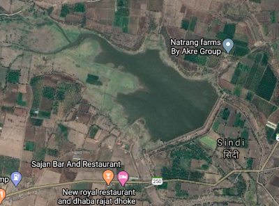
12. Bhagimahari. ( Latutude :21.420712N , Longitude : 79.1214752E)


Map & link uploaded Aug- Sept 2020.
For viewing the surrounding areas and map page click HERE.
Information about Bhagimahari Irrigation Project.
Official Designation of Bhagimahari Dam Irrigation Project is " Bhagimahari Dam , D - 03418 " . However local and popular name is " Bhagimahari Lake / Bhagimahari Talav ". Bhagimahari Irrigation Project is constructed as part of irrigation project by the Government of Maharashtra. It was completed in 1973 . It is built on a Local Nallah near city of Ramtek in Nagpur District of Maharashtra . The dam is an Earth fill dam .The length of dam is 598 m ( 1961.942 ft ) , while the height of the dam above lowest foundation is 12 m ( 39.3701 feet ) . Project has no proper Spillway of any type.Length of the spillway is not known, spillway is un-gated.Its catchment area is not known . Maximum / Gross storage capacity is 1.627 MCM. Live storage capacity is 1.573 MCM. Now a days almost all the water bodies make for good picnic spots and so does this place.
( Note : Blue area in normal map corresponds to Maximum / Full Reservoir Level.)
13. Zilpa . ( Latitude 21.337730 N, Longitude
78.699971 E.)


Map & link uploaded Aug- Sept 2020.
For viewing the surrounding areas and map page click HERE.
Information about Zilpa Irrigation Project.
As per Water Resource Information System web site Zilpa Irrigation project, official designation D-05096 is located at Latitude 21.337730 N, Longitude 78.699971 E. Zipla dam was completed in the year 1973. It is built on local Nallah. Located in Zilpa Village in Katol Tehsil.Nagpur District of Maharashtra. The dam is an Earth fill Dam .The length of dam is 760.4 m ( 2494.7507 ) , while the height of the dam above lowest foundation is 12.08 m ( 39.632546) . Information on catchment area in thousand hectors. Maximum / Gross storage capacity in MCM. Live storage capacity in MCM. are not available as Unable to open source web site
(http://india-wris.nrsc.gov.in/wrpinfo/wiki1.php?show=D05096&str=http://india-wris.nrsc.gov.in/wrpinfo/index.php?=Zilpa_Dam_D05096).
Can not locate the Internet Server or proxiserver..
( Note : Blue area in normal map corresponds to Maximum / Full Reservoir Level.)
14. Ramtek. ( Latutude : 21.3929834N , Longitude : 79.3745041E)

Map & link uploaded Aug- Sept 2020.
For viewing the surrounding areas and map page click HERE.
Information about Ramtek Irrigation Project.
Ramtek Irrigation Project is locally and Popularly known as "Khindsi Lake". Its Official Designation is "Ramtek D 01103". Ramtek Dam was constructed as part of irrigation projects by the Britishers in the year 1923 . It is built on Sur River near Ramtek in Ramtek District of Maharashtra . The dam is an Earth fill Dam .The length of dam is 229 m ( 751.312 ft ) , while the height of the dam above lowest foundation is 22.2 m ( 72.83465 feet ) . Project has a Spillway of other type.Length of the spillway is 57.7 m ( 189.3045 ft ) The spillway is un-gated. It has catchment area of 21.3 thousand hectors. Maximum / Gross storage capacity is 105.13 MCM. Live storage capacity is 103 MCM. Khindsi lake located just 5 kms from ramtek. This beautiful lake surrounded on all side by verdant forests, is a must see. Trekkingaside, the big attraction here is water sports, choose from motor boats, pedl boats, rowing boats or even water scooters there’s really no better way to take in the scenic beauty of the place.
( Note : Blue area in normal map corresponds to Maximum / Full Reservoir Level.)
15. Adegaon. ( Latutude : 21.3660889N , Longitude : 79.4875431E)

Map & link uploaded Aug- Sept 2020.
For viewing the surrounding areas and map page click HERE.
Information about Adegaon Irrigation Project.
Adegaon Irrigation Project, Dam's Official Designation is "Adegaon D-03252" . Adegaon Dam was constructed as part of irrigation projects by Government of Maharashtra in the year 1967 . It is built on Local nallah nearest city to dam is Mauda in Nagpur District of Maharashtra . The dam is an Earth fill Dam .The length of dam is 1097 m ( 3599.081 ft ) , while the height of the dam above lowest foundation is 10.67 m ( 35.00656 feet ) . Project has no proper spillway as such. Length of the spillway is not known.Its catchment area in thousand hectors is not known. Maximum / Gross storage capacity is 1.48 MCM. Live storage capacity is 1.37 MCM. Now a days almost all the water bodies make for good picnic spots. Adegaon Lake is also a popular Tourist attraction for its scenic beauty .
( Note : Blue area in normal map corresponds to Maximum / Full Reservoir Level.)

Map & link uploaded Aug- Sept 2020.
Information about Ranwadi Dam Irrigation Project.
Official Designation of Ranwadi Dam Irrigation Project is " Ranwadi Dam , D - 04701 " . However local and popular name is " Ranwadi Lake / Ranwadi Talav ". Ranwadi Dam was constructed as part of Irrigation Projects by the Government of Maharashtra in the year 1984 . It is built on and impounds a local Nallah . Nearest city to dam is Narkhed in Nagpur District of Maharashtra . The dam is an Earth fill Dam .The Length of dam is 365 m ( 1197.51 Feet ) , while the Height of the dam above lowest foundation is 14.08 m ( 46.1942 feet ) . Project has no proper spillway as such . Length of the spillway is not known. The Dam has ungated spillway. Dam's catchment area is not known . Maximum / Gross storage capacity is 1.62 MCM. Live storage capacity is 1.38 MCM. Now a days almost all the water bodies make for good picnic spots. Ranwadi Lake is also a popular Tourist attraction for its scenic beauty .
( Note : Blue area in normal map corresponds to Maximum / Full Reservoir Level.)
17. Chandrabhaga. ( Latutude : 21.2706594N , Longitude : 78.7648487E )

17. Chandrabhaga. ( Latutude : 21.2706594N , Longitude : 78.7648487E )

Map & link uploaded Aug- Sept 2020.
For viewing the surrounding areas and map page click HERE.
Information about Chandrabhaga Dam Irrigation Project.
Official Designation of Chandrabhaga Dam Irrigation Project is " Chandrabhaga ,D 01360 " . However local and popular name is " Chandrabhaga Lake / Chandrabhaga Talav ". Chandrabhaga Dam was constructed as part of irrigation projects by Government of Maharashtra in the year 1973. It is built on Chandrabhaga River. Nearest city to dam is Kalmeshwar in Nagpur District of Maharashtra . The dam is an Earth fill Dam .The Length of dam is 2194 m ( 7198.163 ft ) , while the Height of the dam above lowest foundation is 21.1 m ( 69.225 feet ) . Project has a Spillway of Ogee type.Length of the spillway is not known.Dam has catchment area of 4.845 thousand hectors. Maximum / Gross storage capacity is 8.886 MCM. Live storage capacity is 8.015 MCM. Now a days almost all the water bodies make for good picnic spots. Urkundapar Lake is also a popular Tourist attraction for its scenic beauty
Incidently there are three more Dam Projects in India with the same name ,second near Amravati Project no D 03111, third in Rajasthan Project no D 00103 and the forth in Gujrat Project no D 05169.
( Note : Blue area in normal map corresponds to Maximum / Full Reservoir Level.)

Map & link uploaded Aug- Sept 2020.
For viewing the surrounding areas and map page click HERE
Information about Paradsinga Dam Irrigation Project. Official Designation of Paradsinga Dam Irrigation Project is " Paradsinga Dam , D - 04525 " . However local and popular name is " Paradsinga Lake / Paradsinga Talav ". Paradsinga Dam was constructed as parts of Irrigation Projects by the Government of Maharashtra in the year 1972 . It is built on and impounds a local Nallah . Nearest city to dam is Narkhed in Nagpur District of Maharashtra . The dam is an Earth fill Dam .The Length of dam is 1040 m ( 3412.073 Feet ) , while the Height of the dam above lowest foundation is 14.07 m ( 46.1614 feet ) . Project has no proper spillway as such . Length of the spillway is not known. The Dam has ungated spillway . Dam's catchment area is not known . Maximum / Gross storage capacity is 1.861 MCM. Live storage capacity is 1.721 MCM. Now a days almost all the water bodies make for good picnic spots. Paradsinga Lake is also a popular Tourist attraction for its scenic beauty .
( Note : Blue area in normal map corresponds to Maximum / Full Reservoir Level.)
19. Junewani. ( Latutude : 21.2760182N , Longitude : 78.5233641E )

Map & link uploaded Aug- Sept 2020.
For viewing the surrounding areas and map page click HERE.
Information about Junewani Dam Irrigation Project.
( Note : Blue area in normal map corresponds to Maximum / Full Reservoir Level.)
20. Khumari. ( Latutude : 21.3210404N , Longitude : 78.8515377E )
For viewing the surrounding areas and map page click Here.
Information about Khumari Dam Irrigation Project.
20. Khumari. ( Latutude : 21.3210404N , Longitude : 78.8515377E )

Map & link uploaded Aug- Sept 2020.
Information about Khumari Dam Irrigation Project.
Official Designation of Khumarii Dam Irrigation Project is " Khumari Dam , D - 03194 " . However local and popular name is " Khumari Lake / Khumari Talav ". Khumari Dam was constructed as part of irrigation projects by Government of Maharashtra in the year 1993 It is built on Khumari Nallah River , nearest city to dam is Kalmeshwar in Nagpur District of Maharashtra . The dam is an Earth fill Dam .The Length of dam is 955.7 m ( 3135.4987 ft ) , while the Height of the dam above lowest foundation is 15.6 m ( 51.1811 feet ) . Project has a Spillway of other type.Length of the spillway is 106.7 m ( 350.065 ft ) The spillway is un-gated.Dam has catchment area of 2.688 Thousand Hectors. Maximum / Gross storage capacity is 5.071 MCM. Live storage capacity is 4.485 MCM. Now a days almost all the water bodies make for good picnic spots. Khumari Lake is also a popular Tourist attraction for its scenic beauty .
No comments:
Post a Comment