DAMS IN NAGPUR DISTRICT - PART ONE.(EDITED}
All 33 blogs covering 380 dams in 11 Districts of Vidarbha Region were edited between Aug & Sept 2020. For details go to blog "Vidarbha Region. Edit-Now - Why". Link here.
There are total of 54 Major Dams ( Height from foundation 10 meters or more ) in Nagpur District. Kochi Barrage,(excluded in edit as only dms covered) Information on these dams is covered in FIVE parts.
Information on dams which are covered in each Part is given below.
Part One.1. Nagalwadi. 2. Khekranala. 3. Mahurkund. 4. Raibasa. 5.
Nanda. 6. Umri. 7 Kolar. 8. Kesar Nala. 9. Suwardhara. 10. Kamthikhairy
/ Pench Dam.
Part Two. 11. Sarekha. 12. Bhagimahari. 13. Zilpa. 14. Ramtek. 15. Adegaon. 16. Ranwadi. 17. Chandrabhaga 18. Paradsinga. 19. Junewani. 20. Khumari.
Part
Three. 21. Surabardi. 22. Vena
/
Wena. 23. Jam. 24. Mordham. 25. Kotwalbordi. 26. Nandora. 27.
Dhotewada. 28. Nandera. 29. Zilpi. 30. Ambazari. 31. Salaimenda. 32. Vyphadpitesur
Part
Four. 33.
Nanhi. 34. Khadki. 35. Kanholibara. 36. Anjangaon. 37. Walkeshwar38.
Navegaon. 39. Ukarwahi. 40. Paradgaon. 41. Saiki Nalla
. 42. Gothangaon. 43.
Pandharabodi. 44. Makardhokada.
Part Five. 45. Lower wunna / Wadgaon. 46. Lower Wunna/ Nand.47. Nishanghat. 48. Botezari. 49. Khandezari. Nand.47. Nishanghat. 48. Botezari. 50. Urkundapar.51. Wani. 52. Totladoh. 53 Chorbahuli.
54 Pendhari.
1. Nagalwadi. ( Latutude : N Longitude : 79.0345287E )

Information about Nagalwadi Irrigation Project.
Nagalwadi Irrigation Project is constructed as part of irrigation project by the Government of Maharashtra. It was completed in 1978. It is built on a Local Nallah near city of Parseoni in Nagpur District of Maharashtra . The dam is an Earth fill dam .The length of dam is 157 m ( 515.092 ft ) , while the height of the dam above lowest foundation is 16.37 m ( 53.7073 feet ) . Project has no proper spillway of any type . Its catchment area is not known . Maximum / Gross storage capacity is 2.679 MCM. Live storage capacity is 2.24 MCM. Now a days almost all the water bodies make for good picnic spots and so does this place.
( Note : Blue area in normal map corresponds to Maximum / Full Reservoir Level.)
2. Khekaranalla. ( Latutude : 21.5463434N Longitude : 78.9506721E )
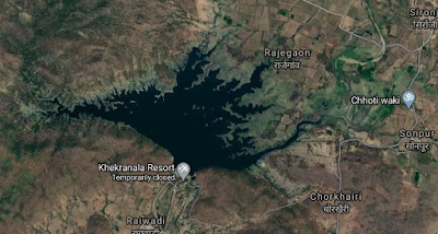
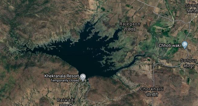
Map & link uploaded Aug- Sept 2020.
For viewing the surrounding areas and map page click HERE.
Information about Khekaranalla Irrigation Project.
Khekranalla commonly written as Khekhra Nala is actually a medium irrigation project by the Government of Maharashtra. Official Designation of Khekhra Nala Dam Irrigation Project is " Khekhra Nala Dam , D - 05112 " . It was completed in 1988. It is built on a river Khekara Nalla near city of Parseoni in Nagpur District of Maharashtra . The dam is an Earth fill dam .The length of dam is 330 M ( 98.4252 ft) , while the height of the dam above lowest foundation is 24.5M ( 80,38 ft.) . Project has chute type of spillway . Length of the spillway is is not known. . The Dam has 4 Radial type of spill gates. The Dam's catchment area is 4.955 Thousand Hectors . Maximum / Gross storage capacity is 26.325 MCM. Live storage capacity is 23.81 MCM.
( Note : Blue area in normal map corresponds to Maximum / Full Reservoir Level.)
3. Mahurkund. ( Latutude : 21.5227958N Longitude : 79.0002126E )

Map & link uploaded Aug- Sept 2020.
For viewing the surrounding areas and map page click HERE.
Information about Mahurkund Irrigation Project.
Mahurkund Irrigation Project is constructed as part of irrigation project by the Government of Maharashtra.Official Designation of Mahurkund Dam Irrigation Project is " Mahurkund Dam , D - 4281 " It was completed in 1980. It is built on a Local Nallah near city of Saoner in Nagpur District of Maharashtra . The dam is an Earth fill dam .The length of dam is 500 m (1640.42 ft ) , while the height of the dam above lowest foundation is 14.31 m ( 46.9488 feet ).Its catchment area is not known . Maximum / Gross storage capacity is 1.51 MCM. Live storage capacity is 1.357 MCM. Now a days almost all the water bodies make for good picnic spots and so does this place.
( Note : Blue area in normal map corresponds to Maximum / Full Reservoir Level.)
4. Raibasa. ( Latutude : 21.4720598N , Longitude : 78.8395643E )


Map & link uploaded Aug- Sept 2020.
For viewing the surrounding areas and map page click HERE.
Information about Raibasa Irrigation Project.
Official Designation of Raibasa Dam Irrigation Project is " Raibasa Dam , D - 04665 " . However local and popular name is " Raibasa Lake / Raibasa Talav ". Raibasa Dam was constructed as part of irrigation projects by Government of Maharashtra in the year 1976 . It is built on Local nallah , nearest city to dam is Saoner in Nagpur District of Maharashtra . The dam is an Earth fill Dam .The length of dam is 703 m ( 2306.43 ft ) , while the height of the dam above lowest foundation is 13.3 m ( 43.635 feet ) . Project has no proper spillway as such. Length of the spillway is not known.Dam's catchment area is not known . Maximum / Gross storage capacity is 1.78 MCM. Live storage capacity is 1.47 MCM. Now a days almost all the water bodies make for good picnic spots. Raibasa Lake is also a popular Tourist attraction for its scenic beauty .
( Note : Blue area in normal map corresponds to Maximum / Full Reservoir Level.)
5. Nanda. ( Latutude : 21.4337753N Longitude : 78.7463844E )


Map & link uploaded Aug- Sept 2020.
For viewing the surrounding areas and map page click HERE.
Information about Nanda Irrigation Project.
Official Designation of Nanda Dam Irrigation Project is " Nanda Dam , D - 04417 " . However local and popular name is " NandaLake / Nanda Talav ". Nanda Dam was constructed as part of irrigation projects by Government of Maharashtra in the year 1976. It is built on Local nallah , nearest city to dam is Saoner in Nagpur District of Maharashtra . The dam is an Earth fill Dam .The Length of dam is 345 m ( 1131.89 ft ) , while the Height of the dam above lowest foundation is 17.31 m ( 56.79133 feet ) . Project has no proper spillway as such.Length of the spillway is not known. The spillway is un-gated.Dam's catchment area is not known . Maximum / Gross storage capacity is 1.105 MCM. Live storage capacity is 0.985 MCM. Now a days almost all the water bodies make for good picnic spots. Nanda Lake is also a popular Tourist attraction for its scenic beauty .
( Note : Blue area in normal map corresponds to Maximum / Full Reservoir Level.)
6. Umri. ( Latutude : 21.4338353N Longitude : 78.8058436E )
Map & link uploaded Aug- Sept 2020.
For viewing the surrounding areas and map page click HERE.
Information about Umri Irrigation Project.
There are two more projects with similar name , 1. Umri Dam -D-04964 near Arvi , Maharashtra and 2nd, Umri Tank -D-05721 in Gujrat . Official Designation of Umri Dam Irrigation Project is " Umri Dam , D - 01277 " . However local and popular name is " Umri Lake / Umri Talav ". Umri Dam was constructed as part of irrigation projects by Government of Maharashtra in the year 1971 It is built on Ambadoh River.Nearest city to dam is Saoner in Nagpur District of Maharashtra . The dam is an Earth fill Dam .The length of dam is 500 m ( 1640.42 ft ) , while the height of the dam above lowest foundation is 21.51 m ( 70.5708 feet ) . Project has a Spillway of Ogee type . Length of the spillway is not known.The spillway is un-gated. Dam's has catchment area of 2.918 thousand hectors. Maximum / Gross storage capacity is 5.9 MCM. Live storage capacity is 5.77 MCM. Now a days almost all the water bodies make for good picnic spots. Umri dam Lake is also a popular Tourist attraction for its scenic beauty.
( Note : Blue area in normal map corresponds to Maximum / Full Reservoir Level.)
7. Kolar. ( Latutude : 21.4063289N Longitude : 78.8015842E )

Map & link uploaded Aug- Sept 2020.
Information about Kolar Irrigation Project.
Official Designation of Kolar Dam Irrigation Project is " Kolar Dam , D - 02839 " . However local and popular name is " Kolar Lake / Kolar Talav ". Kolar Dam was constructed as part of irrigation projects by Government of Maharashtra in the year 1984 . It is built on Kolar River . Nearest city to dam is Saoner in Nagpur District of Maharashtra . The dam is an Earth fill Dam .The Length of dam is 3092 m ( 10144.36 ft ) , while the Height of the dam above lowest foundation is 30.11 m ( 198.7860 feet ) . Project has a Spillway of Ogee type.Length of the spillway is 170 mtrs ( 557.743 ft ) The spillway is un-gated . It has catchment area of 17.613 thousand hectors. Maximum / Gross storage capacity is 35.38 MCM. Live storage capacity is 31.32 MCM. Now a days almost all the water bodies make for good picnic spots. Kolar Lake is also a popular Tourist attraction for its scenic beauty.
( Note : Blue area in normal map corresponds to Maximum / Full Reservoir Level.)
8. Kesar Nala. ( Latutude : 21.3646901N Longitude : 78.8317966E )

Map & link uploaded Aug- Sept 2020.
For viewing the surrounding areas and map page click HERE.
Information about Kesar Nala Irrigation Project.
Official Designation of Kesar Nala Dam Irrigation Project is " Kesar Nala Dam , D - 01359 " . However local and popular name is " Kesar Nala / Kesar Nala Talav ". Kesar Nala Dam was constructed as part of irrigation projects by Government of Maharashtra in the year 1974 It is built on Kesar Nala River, nearest city to dam is Kalmeshwar. in Nagpur District of Maharashtra . The dam is an Earth fill Dam .The Length of dam is 600 m ( 1968.5 ft ) , while the Height of the dam above lowest foundation is 18.82 m ( 61.7454 feet ) . Project has Ogee type of spillway . Length of the spillway is not known.The spillway is un-gated.Dam's catchment area is 1.714 thousand hectors. Maximum / Gross storage capacity is 5.142 MCM. Live storage capacity is 3.87 MCM. Now a days almost all the water bodies make for good picnic spots. Kesar Nala Lake is also a popular Tourist attraction for its scenic beauty.
( Note : Blue area in normal map corresponds to Maximum / Full Reservoir Level.)
9. Suwardhara. ( Latutude : 21.4884854N Longitude : 79.1219366E )

Map & link uploaded Aug- Sept 2020.
For viewing the surrounding areas and map page click HERE.
Information about Suwardhara Irrigation Project.
Official Designation of Suwardhara Dam Irrigation Project is "Suwardhara Dam , D - 04885 " . However local and popular name is " Suwardhara Lake / Suwardhara Talav ".Suwardhara Irrigation Project is constructed as part of irrigation project by the Government of Maharashtra. It was completed in 1968.It is built on a Local Nallah near city of Parsivini in Nagpur District of Maharashtra . The dam is an Earth fill dam .The length of dam is 162 m ( 531.496 ft ) , while the height of the dam above lowest foundation is 13.23m ( 43.4055 feet ) . Project has a no proper Spillway of any type.,any information about spillway is not known. Maximum / Gross storage capacity is 7.937 MCM. Live storage capacity is 1.83 MCM. Now a days almost all the water bodies make for good picnic spots and so does this place.
( Note : Blue area in normal map corresponds to Maximum / Full Reservoir Level.)
10. Kamthikhairy / Pench Dam. ( Latutude : 21.4884854N Longitude : 79.1219366E )

Map & link uploaded Aug- Sept 2020.
For viewing the surrounding areas and map page click HERE.
Information about Kamthikhairy (Pench) Irrigation Project.
Name in the National Register of Dams is Kamthikhairy Dam and, Official Designation of Kamthikhairy (Pench) Dam Irrigation Project is " Kamthikhairy (Pench) Dam , D - 01100 " . However local and popular name is " Pench Dam , Pench Lake / Pench Talav ". Here Local popular name will be used . Pench Irrigation Project is constructed as part of irrigation project by the Government of Maharashtra. It was completed in 1976.It is built on Pench River near city of Parsivini in Nagpur District of Maharashtra . The dam is an Earth fill dam .The length of dam is 2248 m ( 7375.33 ft ) , while the height of the dam above lowest foundation is 32 m ( 105.0 feet ) . Project has Ogee type of spillway . Length of the spillway is 237 m ( 777.56 Feet ). The Dam has 16 Radial type of spill gates . The Dam's catchment area is 466.1 Thousand Hectors . Maximum / Gross storage capacity is 230 MCM. Live storage capacity is 180.00 MCM. Almost all the water bodies make for good picnic spots and so does this place.Location in famous Tiger Reserve is added attraction.
( Note : Blue area in normal map corresponds to Maximum / Full Reservoir Level.)